Forecast for the Skyline Area Mountains

Brett Kobernik
Issued by Brett Kobernik on
Saturday morning, December 7, 2019
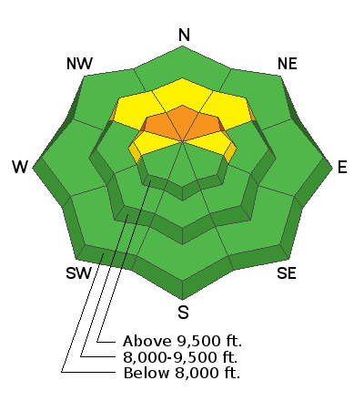
The overall avalanche danger is LOW to MODERATE. You can travel safely in the majority of the terrain along the Skyline. There's still a chance you could find trouble in the high elevation steep northerly facing slopes. Places where a person could trigger an avalanche include all of the following:
  • Upper elevations above about 9000'
  • Slopes that face northwest, north and northeast
  • Steep slopes approaching 40 degrees
Low
Moderate
Considerable
High
Extreme
Learn how to read the forecast here
Special Announcements
Welcome to the First Annual Avalanche Awareness Week. We have 20 events scheduled for this week. Check out the schedule here and we hope to see you at an event.
Need a Christmas present for your favorite backcountry partner? Get one of these cool t-shirts to support the UAC and other avalanche centers across the U.S.
As part of your early season tune-up, consider taking an avalanche class. We have lots of avalanche education classes listed already, from Know Before You Go to Companion Rescue to our Backcountry 101. Click on the Education menu on our webpage for a full list of classes from the UAC and other providers. Check out the Know Before You Go eLearning program for free, online, avalanche classes.
Weather and Snow
Temperatures are very mild this morning with many higher elevation stations above freezing. Southwest wind is starting to increase along the upper ridges. We should see the wind continue to increase today as the next storm moves in. Cloud cover will increase as the day goes on. Most of the snowfall will be Sunday.
This doesn't look like a huge storm. I'm thinking around 6 inches of new snow. Wind will shift more west then northwest as the storm moves through.
It looks like there won't be another storm for about a week after this one.
Ad
Avalanche Problem #1
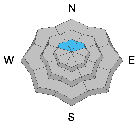
Persistent Weak Layer
Type
Location
Likelihood
Size
Description
My partner and I continued to experience collapsing of the snowpack along with shooting cracks while traveling around on the upper elevation northerly terrain on Friday. This is where the entire snowpack suddenly goes "whoomp"! We collapsed the weak sugary snow near the ground that accumulated in October. This is bullseye information. It tells us that on steep enough slopes, the snowpack is still capable of producing an avalanche. The small storm on Sunday probably won't bring enough new snow to cause natural avalanches but it might make things more sensitive to people.
Additional Information
This forecast is from the U.S. Forest Service, which is solely responsible for its content. This forecast describes general avalanche conditions and local variations always occur.