

Forecast for the Moab Area Mountains

Issued by Eric Trenbeath on
Sunday morning, February 24, 2019
Sunday morning, February 24, 2019
A CONSIDERABLE avalanche danger remains on steep, wind drifted slopes that have primarily a northerly aspect. The problem is most widespread at upper elevations, but exposed, mid elevation slopes are also suspect. A triggered wind slab also has the potential to step down into a buried, persistent weak layer causing a deeper, and much more dangerous avalanche. Steep, rocky, northerly facing terrain, and areas with a shallower snowpack are where you are most likely to encounter this problem. Most other terrain has a MODERATE danger. As the day heats up, be alert to signs of wet snow instability on sun exposed slopes such as roller balls or pin wheels, and stay off of slopes that are getting wet and sloppy.
Low
Moderate
Considerable
High
Extreme
Learn how to read the forecast here
 Special Announcements
This advisory will be updated on Tuesday, Feb 26. For the most current information check out these observations from Chris Benson and Dave Garcia who were out on Sunday.
 Weather and Snow
Skies are mostly clear, WSW winds are blowing 15-25 mph along ridge tops, and 10,000' temps are in the low single digits. We'll see a few high clouds today, WSW winds will be mostly light, and high temps today will warm up into the mid 20's, the warmest we've seen in awhile. Overall, It's going to be another beautiful day in the mountains with lots of fresh powder to be had.
Last week's storm cycle brought up to 2' of light, fluffy powder to the mountains, and conditions are about as good as they get. A strong, late February sun has likely crusted over south facing slopes, but excellent powder can still be had on northerly aspects. People were out in force yesterday enjoying the sunshine and fresh snow. Tim Mathews and company were out in the vicinity of the Trans La Sal Trail and sent in this excellent observation.
New snow totals in Gold Basin (10,000')
Snotel totals at the Geyser Pass Trailhead (9600') y
Wind, temperature, and humidity on Pre Laurel Peak (11,700')
National Weather Service point forecast.
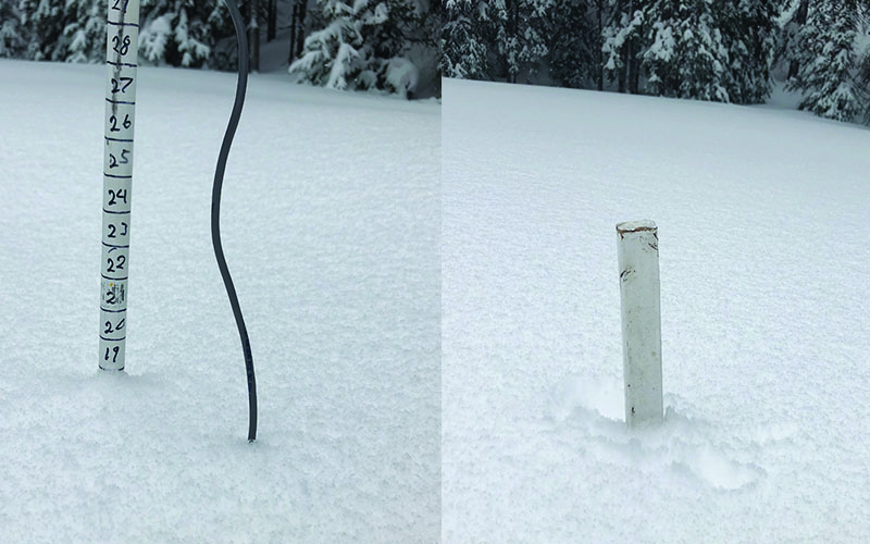
Snow totals from the Thu-Fri storm. Also, it looks like we're going to need an extension on top of our total depth stake! Base depth is 82"! Seasonal average to date is 125%.
 Recent Avalanches
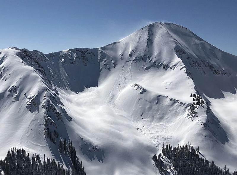
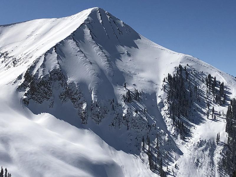
Under clear skies we got a good look around in Gold Basin yesterday and noted several large natural avalanches that had run during the storm. These slides were 3'-5' deep and appeared to be failing on a buried persistent weak layer. I also heard a report of natural activiy in Dory Canyon.
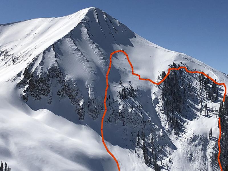

Avalanche Problem #1
Wind Drifted Snow
Type
Location
Likelihood
Size
Description
As has been the case for several weeks now, wind drifted snow continues to be our primary concern. Deep drifts from the last storm event have formed on the lee sides of ridge crests and terrain features on slopes facing NW-N-E. These drifts will primarily be found in upper elevation terrain though some exposed mid elevation slopes are also susceptible. At the highest elevations, a shift in wind direction has also deposited shallower, and more isolated drifts on to southerly aspects. Though gaining strength, I think human triggered avalanches up to 3' deep remain likely on steep, wind drifted slopes. A triggered wind drift also has the potential to step down into a buried, persistent weak layer causing a deeper, and even more dangerous avalanche.
Avalanche Problem #2
Persistent Weak Layer
Type
Location

Likelihood
Size
Description
Recent natural avalanche activity, as well as a remotely triggered avalanche last week, demonstrate that a dangerous persistent weak layer problem still exists. The problem is becoming less widespread, but that perhaps makes it more insidious. Areas with a shallower snowpack are the most suspect and this includes slopes that have already avalanched, or that have been previously wind scoured. Steep, rocky slopes facing N-NE-E have been the most active, but weak snow and poor test results are still being encountered on SE facing slopes. Careful snow stability analysis is essential, and the bottom line is that local observers and I are going to continue to avoid slopes steeper than 35 degrees, especially those with a northerly aspect.
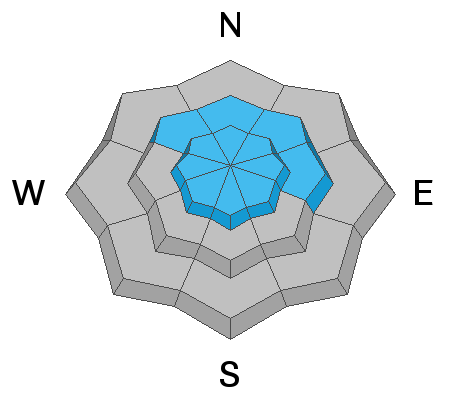
Avalanche Problem #3
Wet Snow
Type
Location
Likelihood
Size
Description
As the day heats up, we may see some shallow, wet avalanche activity on sun exposed slopes. Stay off of slopes that grow wet and sloppy, and look for signs of instability such as pinwheels, rollerballs, or loose snow sluffs.
Additional Information
Groomers will up today!
Check out this clip of local Moab sledders playing it safe and making sure their beacons are on at the Geyser Pass Trailhead.
General Announcements
Your information can save lives. If you see anything we should know about, please help us out by submitting snow and avalanche observations HERE. You can also call me at 801-647-8896, or send me an email: eric@utahavalanchecenter.org.
Support the UAC through your daily shopping. When you shop at Smith's, or online at REI, Backcountry.com, Patagonia, NRS, Amazon, eBay by clicking on these links, they donate a portion of your purchase to the UAC. If you sell on eBay, you can have your See our Affiliate Page for more details on how you can support the UAC when you shop
This advisory is from the U.S.D.A. Forest Service, which is solely responsible for its content. This advisory describes general avalanche conditions and local variations always occur.