Join us at our 2nd Annual Blizzard Ball

Forecast for the Uintas Area Mountains

Craig Gordon
Issued by Craig Gordon on
Tuesday morning, December 31, 2024
Don't let sunny skies and fresh pow skew your decision making today... the snowpack is super sketchy and the setup is nothing to mess around with-
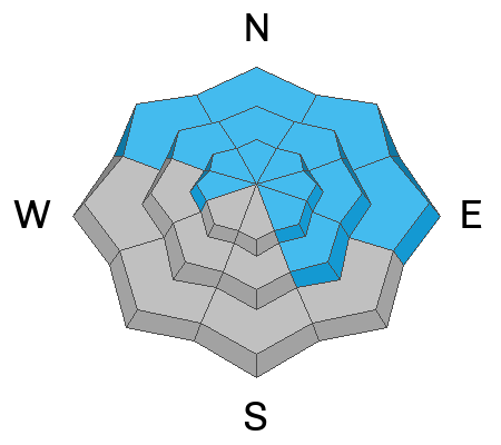
Recent winds coupled with dense, heavy snow deliver a one-two punch and the avy danger is HIGH. We might not be seeing natural avalanches, but HUMAN triggered avalanches are VERY LIKELY, particularly on steep, leeward slopes at and above treeline, and especially in the wind zone in terrain with an easterly component to its aspect. Today’s avalanches will break deeper and wider than you might expect and they'll pack a powerful, season ending, machine vaporizing punch.
MODERATE avy danger is found on the south half of the compass, particularly in mid and lower elevation terrain. While a bit more predictable, human triggered avalanches are still POSSIBLE on steep wind drifted slopes.
Look... the snowpack structure is creepy and there's been no shortage of close calls and near misses. But it doesn't mean we've gotta hide under the bed. In fact, I've been finding fantastic riding in big, wide open meadows and low-angle slopes not surrounded by or connected to nearby steep terrain or overhead hazard above me... done, done, and done.
Low
Moderate
Considerable
High
Extreme
Learn how to read the forecast here
Avalanche Warning
What-
An Avalanche Warning is in effect for the mountains of northern Utah including the western Uintas and Wasatch Range. The avalanche danger for the warning areas is HIGH today
When-
In effect from 0600 AM MST this morning to 0600 AM MST Wednesday.
Why-
Multiple days of heavy snow combined with strong winds have created widespread areas of unstable snow. Deep, dangerous, and possibly unsurvivable human-triggered avalanches are likely.
Weather and Snow
Nowcast- Skies are clear and temperatures cratered into the single digits overnight... sorta like a bad stock option during the early dot.com era. Yesterday's winds shifted to the west and northwest, decreased throughout the day and overnight and currently blow in the teens, creating diesel-gelling windchill to -18 degrees near the high peaks... ouch. And even more of an issue if you parked your diesel gelling rig on a high peak overnight :) The Christmas storm was good to the western Uinta's, delivering a couple feet of dense, heavy snow, vastly improving the riding conditions.
Forecast- It'll be a glorious, yet crisp day in the mountains with mostly sunny skies and temperatures climbing out of the icebox and into the low 20's. Northwest winds blow in the teens near the high peaks and overnight lows dip into the teens.
Futurecast- Increasing clouds and a couple inches of snow ring in the New Year as a weak storm bumps to our north. High pressure and warming temps are on tap to wrap up the work week.
Recent Avalanches
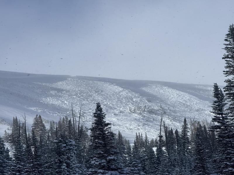
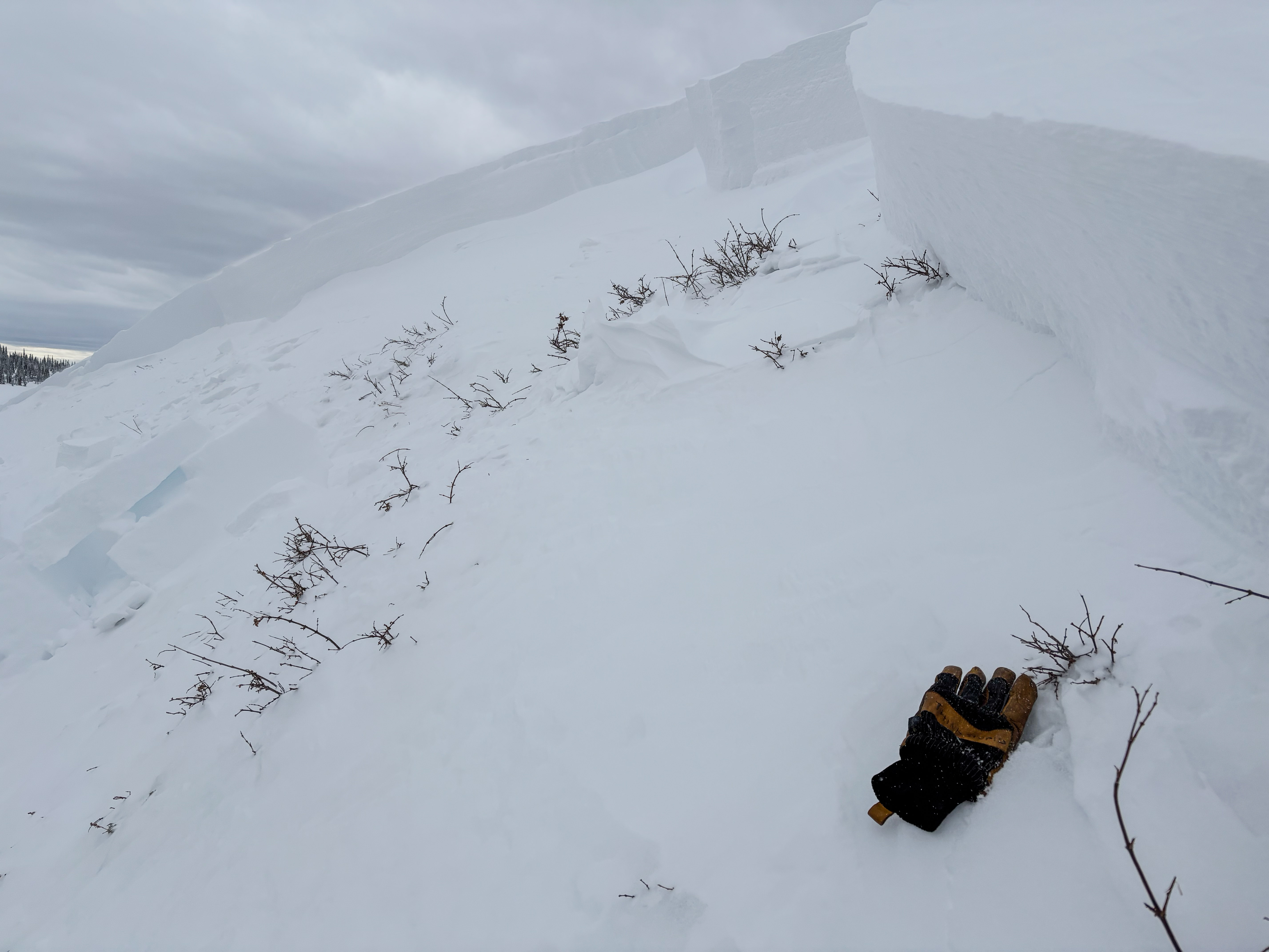
A local, avy-savvy sled crew staying well off of steep slopes, triggered a noteworthy, well-connected piece of snow on Double Hill, in the Whitney Basin yesterday. With all intention of meadow skipping, this slide was triggered in the flats and from a distance, but quickly tipped the dominoes above on a heavily windloaded, northeast facing slope in the windzone at 10,600'. Breaking 10' deep and close to 1000' wide, it's a meaty slab breaking to the dirt, completely nuking the entire seasons snowpack.
No shortage of natural avalanche activity, human triggered avalanches, and even a close call. Yup, avalanche activity has been widespread across the range. Nearly all avalanches are failing on old, faceted snow buried up to 4’-6' deep on slopes facing the north half of the compass. Recent avalanches are breaking hundreds of feet wide and annihilating the entire season's snowpack.
Huge thanks to everyone for helping us out by providing very timely observations, insight, and honesty. Remember... your intel helps save lives, so please keep the info rollin' in! All those obs and trip reports along with info from neighboring Utah forecast zones are found here.
Ad
Avalanche Problem #1
Persistent Weak Layer
Type
Location
Likelihood
Size
Description
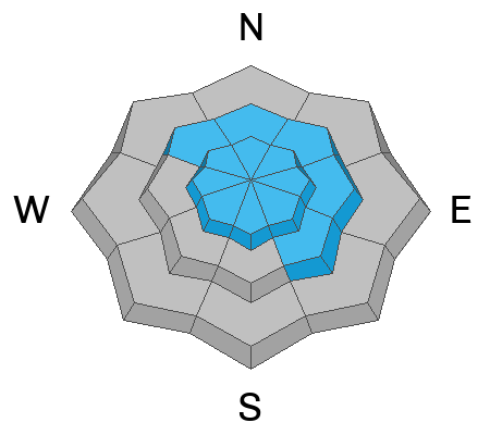
Today isn't the day to gamble on our current snowpack as it is a hand of dangerous cards to play. At all elevations on the north half of the compass, we’re hearing about and seeing avalanches running fast and far, breaking into faceted snow near the ground. Here's where it gets tricky... terrain that already avalanched during the weekend storm doesn't present that fresh, recent avalanche look or showroom smell. In fact, most of the evidence of recent avalanche activity is now blown back in and camouflaged by fresh snow. Problem is... any slope that didn't avalanche, waits for us to roll along and knock the legs out from underneath or even from an adjacent slope. If you're on the receiving end, today's avalanches are gonna meaty, pack a devastating punch and will instantly ruin your day, as well as those waiting for you at home.
Avalanche Problem #2
Wind Drifted Snow
Type
Location
Likelihood
Size
Description
Since Friday, winds have been all over the map, forming stiff drifts at mid and upper elevations around the compass. Both fresh and older wind drifts are gonna be hard to identify because they're covered over by a blanket of fresh snow. So, what I'm doing is simply avoiding fat rounded slopes, especially if they sound hollow like a drum. And remember, fresh wind drifts aren't always a manageable avalanche problem. Once triggered, today's drifts can get out of hand quickly and break into deeper, faceted layers in the snowpack.
General Announcements
The Uinta weather station network was upgraded this summer and all that real-time info is found here. Simply click on the "Western Uinta" tab and then the "Weather Stations" tab to find all your weather needs.
We are always looking for snow and avalanche observations or just general riding conditions. So... if you see something, say something. You can reach our team directly by contacting: Craig at craig@utahavalanchecenter.org, 801-231-2170, or Andrew at andy@utahavalanchecenter.org, or 860-460-8142.
General Information
This forecast is from the U.S.D.A. Forest Service, which is solely responsible for its content. This forecast describes general avalanche conditions and local variations always occur. This forecast was issued on Tuesday, December 31st at 04:00AM and expires 24 hours after it was issued. We will update the forecast by 0700 AM tomorrow. But, in the meantime reach out to us with questions, or if you see anything in your travels.