Join us at our 2nd Annual Blizzard Ball

Forecast for the Uintas Area Mountains

Craig Gordon
Issued by Craig Gordon on
Saturday morning, December 14, 2024
Heads up... a solid shot of snow, water, and strong winds are on tap for the next 24 hours and avy danger rises significantly overnight into Sunday morning-
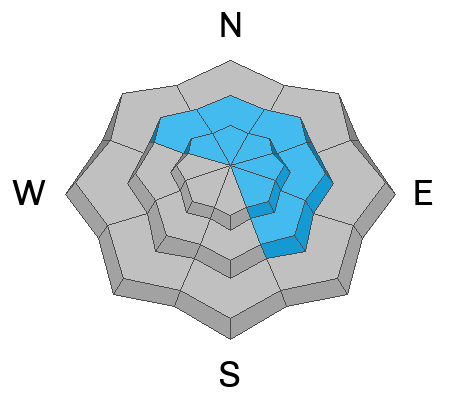
For today... strong southerly winds coupled with a few inches of snow deliver MODERATE avalanche danger in mid and upper elevation terrain. Human triggered avalanches are POSSIBLE, especially on steep wind drifted slopes facing the north half of the compass and particularly in windzone, at and above treeline.
As the storm gets going and hazard increases you've got an exit strategy... meadow skipping in wind sheltered terrain with no overhead hazard is the ticket, where you'll find good riding on low-angle slopes.
Low
Moderate
Considerable
High
Extreme
Learn how to read the forecast here
Special Announcements
Gear up for the season or score great deals on gifts for loved ones this holiday season while supporting the UAC’s efforts. Your participation directly funds the state's avalanche forecasting, awareness, and education programs. Check out the auction found here!
Weather and Snow
Nowcast-
Yesterday's storm was a nice little over-producer across the range, delivering 3" of snow with .13" of H20... in other words, low density pixie dust. With a thin band of clouds overhead, a big, bright, and nearly full, Cold Moon casts an unusual light on our mountains this morning. Temperatures start their day off in the mid teens. The bigger news are the southerly winds which bumped into the 20's and 30's near the high peak right around midnight and continue in that spirit this morning.
Forecast-
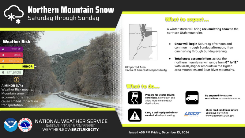
Buckle-up... we're in for a bit of a ride. A brief lull in the action is on tap for this morning, but it'll be short-lived. Thickening clouds deliver a quick round of dense snow by early afternoon... perhaps 2"-4" to smooth out the old snow surface. Temperatures climb into the low 30's while south and southwest winds ramp into the 40's and 50's, gusting to 70 mph near the high peaks late this afternoon.
Futurecast-
Winds switch to the west and the meat of the storm, along with colder air, filters in late tonight. That combo delivers a better shot of low density snow. I'm thinking an additional 3"-6" for tomorrow's sunrise service. Look for a little break late Sunday and Monday with a slightly underwhelming storm slated for Tuesday.
Current Conditions-
Our good friends and partners at Salt Lake's National Weather Service have issued a Winter Weather Advisory for the Uinta Zone.
Recent Avalanches
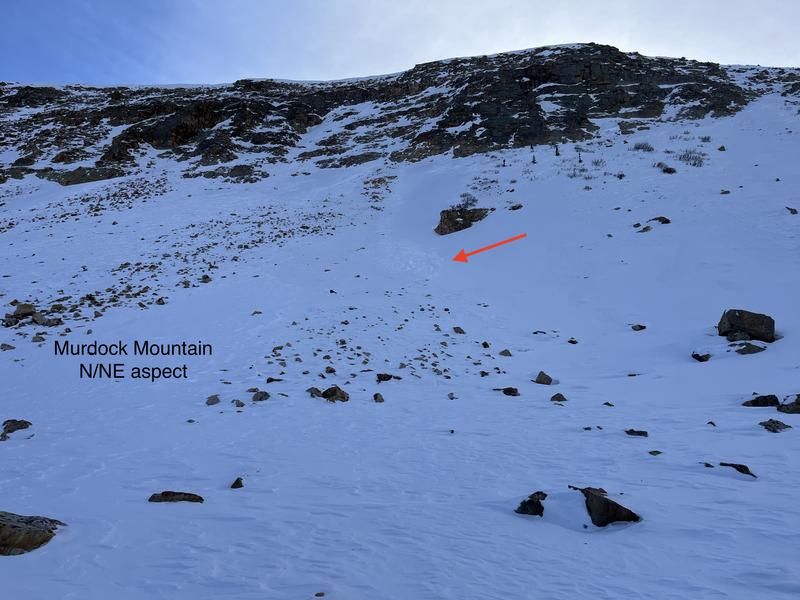
On Thursday, Ted noted this recent little avalanche in Murdock Bowl, a shallow wind drift that dribbled off a steep slope and then gouged into weak, sugary snow as it descended the slope below. Ted also noted... "Where I dug and traveled today it was bottomless weak faceted snow with fist density snow making up the top third of the pack and the rest was large grains of sugary faceted snow. I was basically walking on the ground!" He added... "Things could get interesting when it does snow."
More information on avalanches and current conditions from the range are found HERE.
Ad
Avalanche Problem #1
Wind Drifted Snow
Type
Location
Likelihood
Size
Description
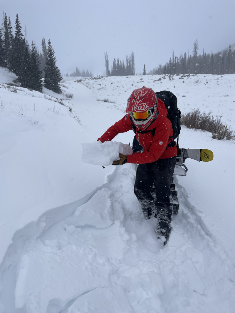
Andy illustrating the setup with recent snow and wind conspiring to create drifts sensitive to our additional weight.
Today's wind coupled with a few inches of fresh snow to work with has no problem whipping up a batch of drifts sensitive to our additional weight. Remember... the snowpack is a complete gong show and today's fresh drifts rest on a variety of weak layers. That said, I’m steering clear of steep, leeward slopes in mid and upper elevation terrain, especially if they appear fat and rounded or sound hollow like a drum. And I remind myself that even a small pocket of wind-drift snow resting on top of weaker snow could knock me off my feet and take me for an unexpected ride.
Avalanche Problem #2
Persistent Weak Layer
Type
Location
Likelihood
Size
Description
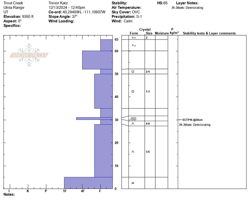
Trevor and Andy's snowpit profile in the image above from Trout Creek yesterday reveals a sketchy setup that's reactive to our snow stability tests.
Early season snow near the ground has grown weak and sugary, but fortunately, this persistent weak layer (PWL) has remained largely dormant because it's missing a key ingredient... a cohesive slab. But that's about to change with more snow, water, and wind on the way this weekend. In fact, I think our days of easy livin' and straightforward yacht-rock avy danger are short-lived. As the storm evolves I suspect the dormant PWL roars back to life and that means it's gonna get tricky and potentially dangerous.
General Announcements
Additional Information
The Uinta weather station network was upgraded this summer and all that real-time info is found here. Simply click on the "Western Uinta" tab and then the "Weather Stations" tab to find all your weather needs.
We are always looking for snow and avalanche observations or just general riding conditions. So... if you see something, say something. You can reach our team directly by contacting: Craig at craig@utahavalanchecenter.org, 801-231-2170, or Andrew at andy@utahavalanchecenter.org, or 860-460-8142.
General Information
This forecast is from the U.S.D.A. Forest Service, which is solely responsible for its content. This forecast describes general avalanche conditions and local variations always occur. This forecast was issued on Saturday, December 14th at 04:00 AM and expires 24 hours after it was issued. We will update the forecast by 0700 AM tomorrow. But, in the meantime reach out to us with questions, or if you see anything in your travels.