Join us at our 2nd Annual Blizzard Ball

Forecast for the Uintas Area Mountains

Craig Gordon
Issued by Craig Gordon on
Wednesday morning, January 8, 2025
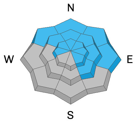
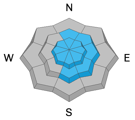
Look for CONSIDERABLE avalanche danger on steep, upper-elevation slopes facing northwest through north through southeast. Human-triggered avalanches are LIKELY and once initiated, may produce a slide breaking 2'-4' deep and hundreds of feet wide. Note to self... while becoming more the exception than the rule, avalanches can still be triggered remotely, or from a distance.
At and above treeline, MODERATE avalanche danger exists on the south half of the compass where my greatest risk is triggering a small, yet quite manageable wind-drift. Switch over to the mid elevation polars (north half of the compass) and you still might encounter a meaty slab that breaks to weaker layers buried in the mid portion of the snopwack.
So here's my exit strategy.... I'm finding quality riding, soft creamy snow, and generally LOW avy danger in wind sheltered, lower elevation terrain and slopes facing the south half of the compass. And of course the sunnies allow for a nice tanning opportunity on a cold January day.
Low
Moderate
Considerable
High
Extreme
Learn how to read the forecast here
Special Announcements
Please join Craig Gordon, that's me, Thursday night from 6-8PM at Mammut HQ for a state of the snowpack prezo. It's gonna be educational... it's bound to be informative.... and sources on the street tell me it might even be entertaining :)
Here's the deets-
Weather and Snow
Nowcast - An inch or two of pixie dust fell straight out of the sky early yesterday morning, adding an ultra low density topper to a remarkably supportable snowpack. As our storm dives to the south it leaves severe clear skies in its wake and an east-northeast flow opens Utah's Port of Entry, allowing cold, dry Wyoming air to filter into the eastern front. East and northeast winds bumped into the in 20's for a few hours Tuesday night, but have since backed off and currently register 5-15 mph near the high peaks. Finger numbing temperatures hover in the low single digits across the board.
Forecast- After a crisp start out of the gates, a glorious day is on tap with mostly sunny skies and temperatures climbing into the 20's. Northerly winds gust into the 30's later today and become a nuisance near the high peaks. Clouds drift into the region late in the day and overnight lows dip into the teens.
Futurecast- A dry cold front slides through our backyard Thursday, bringing colder temperatures and strong northerly winds. Next threat of accumulating snow begins Friday night, with some uncertainty as to the duration of the storm
Current Conditions-
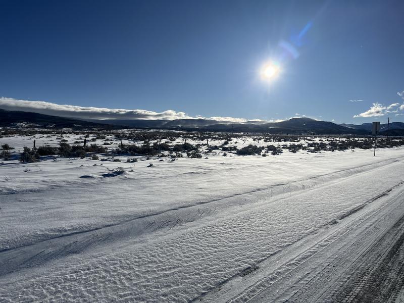
Get it before the wind does. On a go anywhere base, riding and turning conditions are quite good! Our main man on the eastern front provided this frosty image above from the Uinta tundra and has solid report near the Gold Hill area found here.
All Uinta obs and trip reports can be found here.
Recent Avalanches
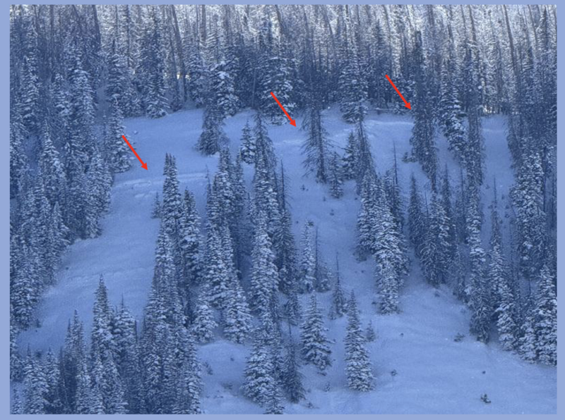
Cheston submitted an awesome trip report and this image from a recent avy in the Moffit zone. He was unsure as to the timing, but it looks rather fresh and there's lots of big game stomping around in terrain that looks like this. Important take away.... avy activity isn't widespread and the walls aren't caving in, but a few landmines are out there waiting for us to roll along and knock the legs out from underneath. More of Cheston's travels and insight found here.
All Uinta obs and trip reports can be found here.
Ad
Avalanche Problem #1
Persistent Weak Layer
Type
Location
Likelihood
Size
Description
What a treat! On our field day on the south half of the range out of Lake Creek yesterday, Paige and I overlapped with snow-pro and avy educator extraordinaire, Joey Manship. What a pleasure to watch Joey, along with local avy-savvy pros, Tyler St. Jeor and Big Al help spread the avalanche gospel to our good friends and longtime partners, a group of law enforcement personnel from Dept. of Natural Resources. Above.... Senor Manship shares his snowpit stability test and hazard philosophy.
As we see fewer recent avalanches and less obvious signs of instability (cracking, collapsing, or whumphing sounds), it may seem like the weak layer is strengthening, but there is still a likely chance of triggering a large avalanche. Pull out your shovel or dig a trench with your track to reveal a dense slab atop the sugary facets, or ya know... some junk in the trunk.
How am I managing this avalanche problem? Easy... I am avoiding it. I don't wanna pull on the dogs tail since I know its bite will deliver avalanches with the potential to be big, scary, and they'll pack a punch that can ruin my day and those waiting for me at home. So... I'm steering clear of avalanche terrain on the north half of the compass, I'm changing aspects, and heading for the sunny slopes where creamy pow meets warm sunshine and delivers quality riding and less risk of triggering an unmanageably large avalanche. Hmm... seems like a good business model... I'll take it!
Avalanche Problem #2
Wind Drifted Snow
Type
Location
Likelihood
Size
Description
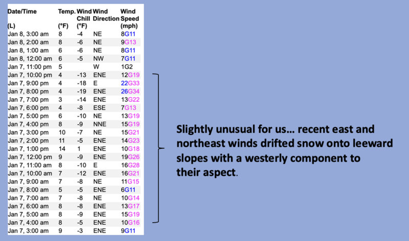
A few shallow drifts are found on the leeward side of upper elevation ridges with a westerly component to its aspect.... a little unusual for us. And while not particularly alarming, a recent drift might catch you off guard. For today... look for rounded, pillows of snow that may sound hollow like a drum. And while becoming more the exception than the rule, don't forget, today's wind slabs can get out of hand quickly if they step-down into faceted weak layers that are now buried several feet deep in the snowpack. You know the drill... lose the wind and you lose the problem... and get great riding to boot!
Additional Information
We are deeply saddened to confirm two avalanche fatalities. The first involved a 38 year old man in Main Porter Fork of Mill Creek Canyon who went missing on Saturday. The second avalanche fatality occurred Tuesday and involved a 54 year old man off Davenport Hill into Silver Fork of BCC. Both individuals were traveling alone in the backcountry. Please know, our hearts are heavy for the family and friends of these riders.
Many thanks to those who responded to these accidents: search and rescue teams from AirMed, LifeFlight, Utah Dept Public Safety, Utah Department of Transportation, Salt Lake County Search and Rescue, Wasatch Backcountry Rescue, Alta Ski Area, and members of the Utah Avalanche Center.
General Announcements
The Uinta weather station network was upgraded this summer and all that real-time info is found here. Simply click on the "Western Uinta" tab and then the "Weather Stations" tab to find all your weather needs.
We are always looking for snow and avalanche observations or just general riding conditions. So... if you see something, say something. You can reach our team directly by contacting: Craig at craig@utahavalanchecenter.org, 801-231-2170, or Andrew at andy@utahavalanchecenter.org, or 860-460-8142.
General Information
This forecast is from the U.S.D.A. Forest Service, which is solely responsible for its content. This forecast describes general avalanche conditions and local variations always occur. This forecast was issued on Wednesday, January 8th at 04:00AM and expires 24 hours after it was issued. We will update the forecast by 0700 AM tomorrow. But, in the meantime reach out to us with questions, or if you see anything in your travels.