Forecast for the Skyline Area Mountains

Brett Kobernik
Issued by Brett Kobernik on
Thursday morning, March 4, 2021
A small amount of new snow will not change the avalanche danger dramatically.
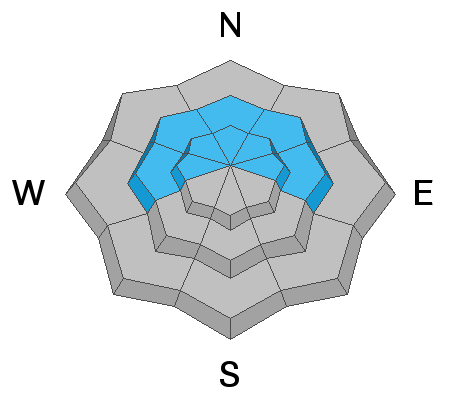
The danger remains CONSIDERABLE in the upper elevation northwest through east facing slopes.
Human triggered avalanches are likely in this terrain on slopes that have not previously avalanched.
Slopes that have already avalanched are much safer at this point.
Low
Moderate
Considerable
High
Extreme
Learn how to read the forecast here
Weather and Snow
Current Conditions: A quick hitting storm system dropped about 4 inches of snow over the last few hours. A little more may trickle in this morning but I'm not expecting much more accumulation. Wind has been from the east and was quite strong overnight but slowed during the onset of the snow and is fairly light in most locations now. Temperatures are in the mid 20s. I'm guessing that the snow is going to be medium density.
Mountain Weather: The storm will linger a bit this morning. It looks like clouds will hang around most of the day. Wind will continue to shift to the northwest and increase to moderate speeds. Temperatures should remain in the mid 20s. Friday looks like a nice sunny day. Another small disturbance will move through Saturday night that might bring a few more inches of snow. Temperatures warm through the weekend.
Ad
Avalanche Problem #1
Persistent Weak Layer
Type
Location
Likelihood
Size
Description
By far, your biggest concern is finding a slope that avalanches breaking into weak snow near the ground. Chances of doing this are becoming less and less but there's still a chance. Today's snow will not increase the danger all that much.