Forecast for the Skyline Area Mountains

Brett Kobernik
Issued by Brett Kobernik on
Saturday morning, March 28, 2020
There is a MODERATE avalanche danger today in areas that have received near a foot of snow this week. While it seems unlikely, human triggered avalanches are possible. Approach steep slopes cautiously and only get onto them after doing thorough assessment of the new snow layers to confirm there is no weakness.
Low
Moderate
Considerable
High
Extreme
Learn how to read the forecast here
Special Announcements
If you rely on the UAC forecasts each day you get out, consider making a donation during our Spring Awareness Campaign to help us continue providing the avalanche forecasts and education you rely on.
The UAC encourages everyone to follow direction from federal, state, city and county officicals. The following is from Joe Dougherty, spokesman for the Utah Division of Emergency Management:
Though outdoor recreation is still permitted under the governor’s Stay Safe/Stay Home directive, we recommend that people maintain a distance of at least 6 feet.
Be extra cautious to avoid injuries outdoors. We are working with our hospital systems to conserve as much personal protective equipment as possible in case of hospitalizations.
Most outdoor injuries can be prevented. Know the conditions and know your limits so you don’t end up in a hospital.
Weather and Snow
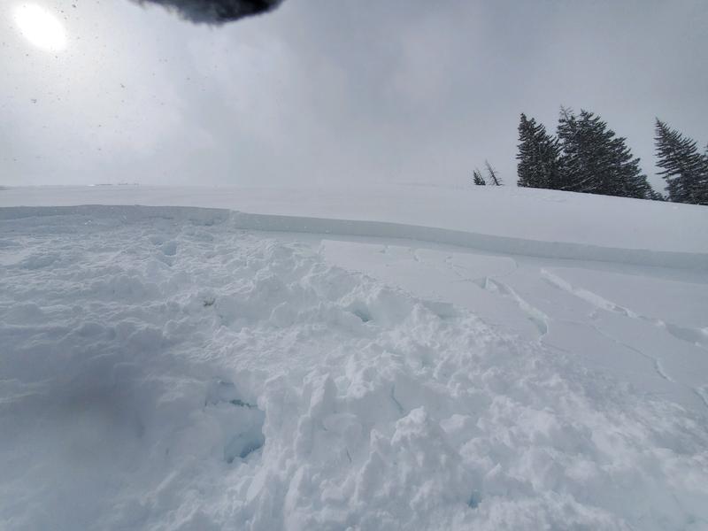
Current Conditions: Another few inches of snow fell overnight. This brings totals to near a foot for the week. It's been a little breezy over the last 24 hours with wind from the northwest. Overnight temperatures were in the mid teens. Riding conditions remain excellent.
Mountain Weather: Lingering snow showers this morning will taper off and we'll see mostly cloudy skies today with high temperatures in the mid 20s. Another storm system will move through Sunday into Monday bringing around 6 inches of snow or perhaps a bit more.
Recent Avalanches
There have been no reported avalanches on the Skyline this week. However, there was a snowmobile triggered avalanche in the Gooseberry zone of Fish Lake on Friday. It was about a foot deep or a bit more and involved the newer layers of snow.
Ad
Avalanche Problem #1
New Snow
Type
Location
Likelihood
Size
Description
While it seems unlikely that the new snow is going to cause problems, it would be wise to approach steep slopes with caution today. We've slowly added up quite a bit of snow over the last few weeks. Slowly adding snow to the snowpack is generally a good thing and usually results in stable conditions. However, it is always a good idea to spend some time looking around and doing some tests before just diving into steep slopes. First off, look for any recent avalanches. Next, look for any signs of recent wind drifted snow like fresh cornices or larger "pillowy" looking drifts. Test the snow by riding on small steep test slopes to see if you initiate any cracking. Dig down with your hand through the new snow and see if you can break off any blocks. Do all this stuff repeatedly to give you an idea if there is any instability within the new snow layers.
Additional Information
New to the backcountry (including riding at closed resorts) - Watch the award-winning, 15 minute Know Before You Go video, or take the 5-part, free online-learning series.

This forecast is from the U.S. Forest Service, which is solely responsible for its content. This forecast describes general avalanche conditions and local variations always occur.