Forecast for the Skyline Area Mountains

Brett Kobernik
Issued by Brett Kobernik on
Tuesday morning, February 4, 2025
The overall avalanche danger today on the Manti Skyline is MODERATE.
Fresh wind drifts and wind slabs in the higher terrain breaking into facets is the main concern. Most will be shallow, a few might break deeper producing a more dangerous slide.
Minor wet snow avalanche activity is possible today in the mid and lower terrain. Avoid steep slopes where the snow is wet and saturated.
Low
Moderate
Considerable
High
Extreme
Learn how to read the forecast here
Special Announcements
Sad news to report from the Monte Cristo area where a snowmobiler was caught, carried, and killed in an avalanche yesterday. We have a team headed to that zone today and will have more details as they are compiled. In the meantime... please know our hearts hurt and our collective energy goes out to friends, family, and everyone involved in this very tragic accident.
Weather and Snow
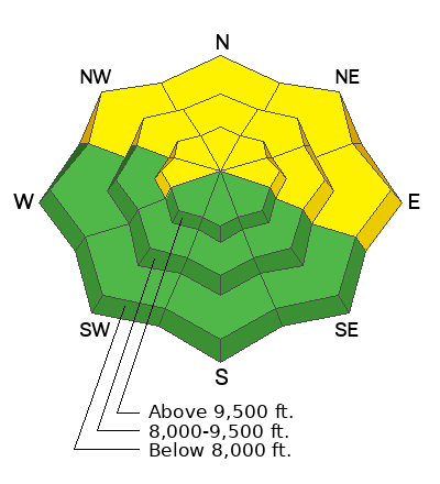
Current Conditions: It's still warm. Temperatures were well into the 40s on Monday and hovered around 35˚ to 40˚ overnight. The wind has been steady in the moderate to strong range from the southwest along the higher terrain for the last couple of days. It is slowing slightly this morning. The snow has become damp and sloppy in the lower elevation. It is damp up to around 9000' on all aspects.
Mountain Weather: It's going to be another warm, cloudy day today. Temperatures will again get to near 40˚ in the high country. Wind will continue from the southwest but will be a bit slower than the last couple of days. A minor disturbance moves through on Wednesday spitting a little snow in the higher terrain. We might see some light rain up to 7000 or 8000'. A cold front moves through Friday which could bring a few inches of snow.
Recent Avalanches
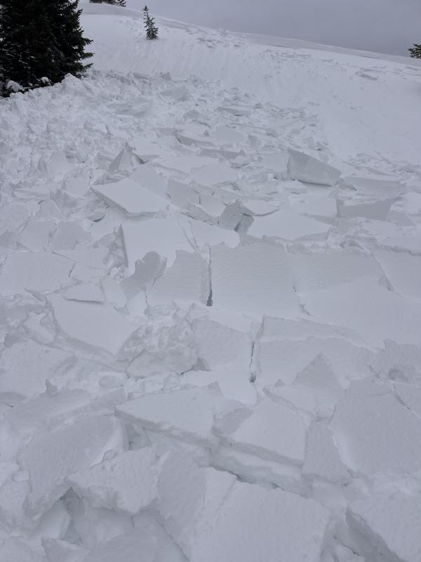
There was a snowmobile triggered avalanche in the Strawberry zone that released on Sunday. It was a wind loaded steep slope above a road, northeast facing, 9200'. This was not on the Skyline but just north of Soldier Summet. We have very similar conditions on the Skyline and a person could find something like this today.
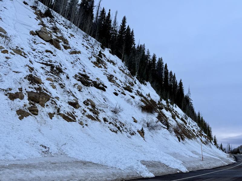
Also, there was some minor loose wet avalanches that released naturally here on the Skyline. This was wet snow gouging into the facets as it ran. I noted them both in Fairview Canyon and Huntington Canyon. They were on northerly facing slopes below about 8500'. More of this is possible today.
Ad
Avalanche Problem #1
Persistent Weak Layer
Type
Location
Likelihood
Size
Description
It's really all about the loose sugary Persistent Weak Layers that are both deeper in the snowpack and closer to the surface. There are scattered areas where human triggered avalanches are possible. The two photos above are great examples of what to look out for today.
  • Areas where the wind has drifted snow and formed drifts and slabs. This is most pronounced in the higher terrain. Watch for and avoid obvious drifts and slabs along any terrain feature in the mid and upper elevation west, north and east facing terrain. North through east facing slopes are the most suspect. Some of these drifts will involve only the upper layers of the snowpack. A few could break deeper.
  • Wet snow avalanches should be considered in the mid and lower elevations. Wet snow is gouging into weak buried facets. You'll want to avoid any steep slope in the mid and lower elevations where the snowpack is wet, saturated, sloppy and punchy. If you are sinking deep into unconsolidated wet snow, this is a clue of unstable conditions.
.
General Announcements
This forecast is from the U.S.D.A. Forest Service, which is solely responsible for its content. This forecast describes general avalanche conditions and local variations always occur.