Forecast for the Skyline Area Mountains

Brett Kobernik
Issued by Brett Kobernik on
Friday morning, February 26, 2021
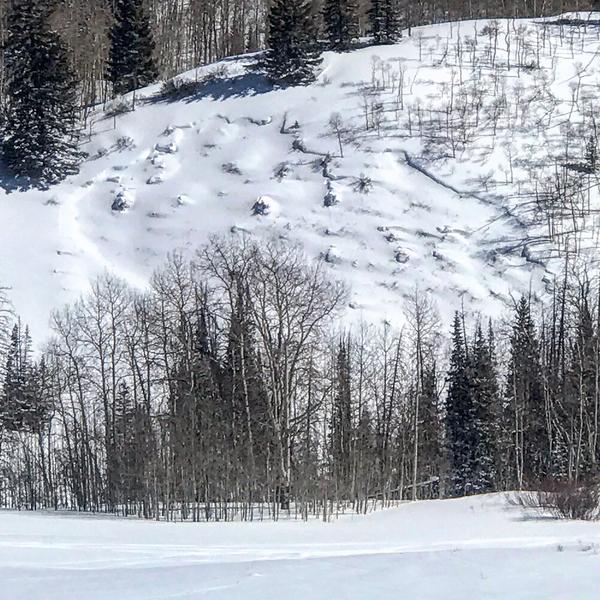
Avalanche conditions remain dangerous.
The avalanche danger is CONSIDERABLE today. Human triggered avalanches are likely.
As things settle, triggering avalanches from a distance is becoming less likely but you won't catch me underneath any steep slopes yet.
Continue to avoid steep slopes while this very unstable snowpack settles.
Low
Moderate
Considerable
High
Extreme
Learn how to read the forecast here
Special Announcements
There's another great video out that highlights the importance of getting trained about avalanche safety. Klim put together this great video. Also, if you need gear, check out the Beck boys right here in Sanpete at Snow Big Deal who are one of the largest Klim dealers in the US.
Weather and Snow
Current Conditions: It was a gorgeous day to be in the mountains on Thursday. Riding conditions are still good in many locations. The wind picked up in the last few hours and is blowing pretty hard along the high terrain from the west southwest. Overnight temperatures were in the teens.
Mountain Weather: We should see partly cloudy skies through mid day then increasing clouds later as the next storm system moves in. West or northwest wind looks like it'll be a bit breezy today. High temperatures should reach around 20˚F in the higher terrain. The brunt of this event is tonight when we should see the most consistent snowfall. It looks like it might remain showery through Saturday with smaller accumulations. This is not a huge snow producer for us. It's looking like 3 to 6 inches total by Sunday.
Recent Avalanches
The avalanche viewing has been spectacular for me this week. I was down in the Gooseberry zone of Fish Lake doing some avalanche training and we were able to see many natural avalanches that had released over the last week and a half. My partners Kreig and Brock Rasmussen said that they have never seen avalanches in some of the locations we viewed. Kreig said that he's never seen so many avalanches viewed from one of the locations we stopped at. This is a tribute to how unusual conditions are this season.
Photo below: One of numerous recent natural avalanches breaking into weak snow near the ground
Photo below: An avalanche that broke into old weak snow near the ground. This is in a very unusual location where avalanches haven't been seen before.
Ad
Avalanche Problem #1
Persistent Weak Layer
Type
Location
Likelihood
Size
Description
The snowpack down in the Gooseberry zone of Fish Lake looked pretty similar to what we have on the Manti Skyline. There is a thick layer of loose sugary faceted snow at the base of the snowpack capped off with a number of layers of new snow above it. It is a very unstable situation. We dug a snowpit in one location and performed a stability test (Extended Column Test) where the weak layer collapsed and propagated as I was finishing cutting and isolating the column. (Video Below) In simple terms, a column of snow will not stand on it's own with the current snowpack structure. This problem is going to remain with us for the near future and perhaps the rest of the winter.