Forecast for the Skyline Area Mountains

Brett Kobernik
Issued by Brett Kobernik on
Wednesday morning, February 12, 2025
The overall danger rating on the Manti Skyline is MODERATE.
The new snow has only increased the danger slightly.
The most dangerous situation is the chance for triggering an avalanche that breaks deeper into loose sugary snow.
Low
Moderate
Considerable
High
Extreme
Learn how to read the forecast here
Weather and Snow
Current Conditions: Yesterday's minor weather event left 3 to 5 inches of new snow on the Skyline. This was the high end of what I was expecting. (Apologies for the storm timing in my forecast. I was expecting the storm to move through in the evening. I was more focused on the weekend storm and wasn't paying attention.) Temperatures have dropped to around 0˚F or colder. The wind has picked up speed a bit blowing from the west in the moderate range along the higher terrain features. There were some stronger speeds along the highest peaks. I'm guessing with the addition of the new snow, the riding conditions are starting to get decent.
Mountain Weather: There are a few low level clouds still hanging around the peaks that should dissipate by mid day. Temperatures are going to stay cold with highs only around 10˚F or a bit warmer. Wind will continue in the moderate speed category from the west northwest. We may see a slight increase in speed this afternoon. Clouds move in Thursday ahead of a decent looking storm Friday and Saturday. Water numbers are trending a little lighter but it still looks like we should see .7 to 1" of water which translates to 8 to 12 inches of snow.
Ad
Avalanche Problem #1
Persistent Weak Layer
Type
Location
Likelihood
Size
Description
The bump in wind speeds over the last 12 hours is no doubt drifting some snow. These fresh drifts may be sensitive but on their own I don't think they pose all that much threat.
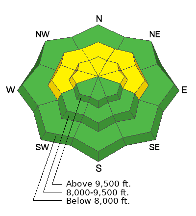
The real issue is where you might trigger something that breaks deeper into loose sugary facets. This is tricky business trying to figure out what slopes might release and which ones won't. There is not too much of a pattern to use. The best advice I can give is that the most likely places to trigger something are going to be in the higher terrain where wind has formed drifts and slabs over the last few weeks. North through east facing slopes are the most suspect. Chances for triggering something that breaks deep aren't all that great today. However, the consequences are increasing as we slowly add more new snow on top of the old Persistent Weak Layers of loose sugar.
.
General Announcements
This forecast is from the U.S.D.A. Forest Service, which is solely responsible for its content. This forecast describes general avalanche conditions and local variations always occur.