Forecast for the Skyline Area Mountains

Brett Kobernik
Issued by Brett Kobernik on
Saturday morning, December 19, 2020
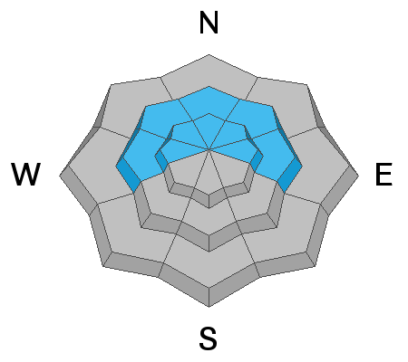
DANGEROUS AVALANCHE CONDITIONS EXIST IN OUR MOUNTAINS RIGHT NOW. The avalanche danger is CONSIDERABLE today on steep mid and upper elevation west, north and east facing slopes. Human triggered avalanches in this terrain are almost certain. Avalanches can be triggered from a distance right now so stay out from under steep slopes where a slide could come down on top of you.
Low
Moderate
Considerable
High
Extreme
Learn how to read the forecast here
Special Avalanche Bulletin
THE AVALANCHE CONDITIONS REMAIN DANGEROUS FOR THE MOUNTAINS OF NORTHERN AND CENTRAL UTAH, INCLUDING THE WASATCH RANGE...THE WESTERN UINTAS AND THE MANTI-SKYLINE PLATEAU. RECENT HEAVY SNOWFALL AND DRIFTING FROM STRONG WINDS HAS CREATED AREAS OF UNSTABLE SNOW. HUMAN TRIGGERED AVALANCHES ARE LIKELY. TRAVEL IN AVALANCHE TERRAIN IS NOT RECOMMENDED. STAY OFF OF AND OUT FROM UNDERNEATH SLOPES STEEPER THAN 30 DEGREES.
Weather and Snow
Current Conditions: Travel conditions have improved from early in the week when we were plowing through the entire snowpack to the ground on skis or snowmobiles. The snowpack has settled and feel like it has some base now. The snow that fell Thursday night was higher density compared to what fell earlier in the week. Overnight temperatures were in the mid teens and west wind was light to moderate in speed.
Mountain Weather: We'll have a couple of nice days of weather ahead. We'll see partly cloudy skies today with temperatures in the low 20s. Northwest wind looks like it'll bump up in speed slightly. Sunday looks similar. The next chance for snow is late Tuesday.
Ad
Avalanche Problem #1
Persistent Weak Layer
Type
Location
Likelihood
Size
Description
Backcountry observations confirmed that we have dangerous avalanche conditions due to weak snow near the ground from November. That snow is VERY loose and sugary. There are a couple of feet of new snow on top of it. On Friday, backcountry travelers experienced numerous collapses or "whoomping" of the snowpack. This is the loose sugary snow failing under the new snow making the entire snowpack settle instantly. This situation is mostly present on the north half of the compass in the mid and especially upper elevations. This is something we'll be dealing with for a little while.