Forecast for the Skyline Area Mountains

Brett Kobernik
Issued by Brett Kobernik on
Friday morning, December 18, 2020
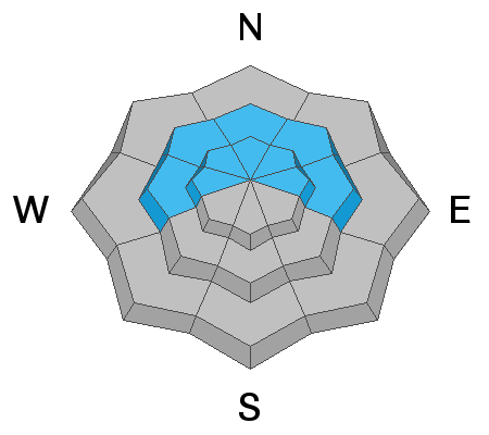
DANGEROUS AVALANCHE CONDITIONS EXIST IN OUR MOUNTAINS RIGHT NOW. There is a HIGH avalanche danger on steep upper elevation more northerly facing slopes. Human triggered avalanches are likely. Avoid steep slopes for the time being.
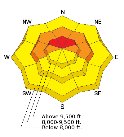
Low
Moderate
Considerable
High
Extreme
Learn how to read the forecast here
Avalanche Warning
THE AVALANCHE DANGER FOR THE MOUNTAINS OF NORTHERN AND CENTRAL UTAH, INCLUDING THE WASATCH RANGE...THE WESTERN UINTAS AND THE MANTI-SKYLINE PLATEAU IS HIGH. RECENT HEAVY SNOWFALL AND DRIFTING FROM STRONG WINDS HAS CREATED WIDESPREAD AREAS OF UNSTABLE SNOW. HUMAN TRIGGERED AND NATURAL AVALANCHES ARE LIKELY. TRAVEL IN AVALANCHE TERRAIN IS NOT RECOMMENDED. STAY OFF OF AND OUT FROM UNDERNEATH SLOPES STEEPER THAN 30 DEGREES.
Weather and Snow
Current Conditions: We squeezed out about 10 inches of new snow in the last 24 hours and it is still lightly snowing. It is much denser than the snow from earlier this week. This will help build base but it also helps build dangerous slabs, one of the ingredients for avalanches. The southwest wind was fairly well behaved with moderate speeds for most of the storm. Temperatures are in the upper teens.
Mountain Weather: We'll see mostly cloudy skies today with lingering light snowfall this morning. Temperatures will remain in the teens and the southwest wind should remain light to moderate in speed. The next few days look nice with plenty of sun expected. As of now, there are no more significant snow storms in the near future.
Ad
Avalanche Problem #1
Persistent Weak Layer
Type
Location
Likelihood
Size
Description
Because I haven't been able to travel around the mountains much due to lack of snow cover, there are a lot of unknowns right now. Here's what we do know:
  • There is old snow from November that is faceted (sugary) and weak.
  • There is up to 2 feet of newer snow on top of the old weak snow.
  • The snow from the last 24 hours is much more dense than the snow from earlier in the week.
  • Collapsing of the snowpack (whoomping) was noted earlier this week.
These are the factors that indicate dangerous avalanche conditions. We should be able to start traveling around a bit easier now and will, no doubt, get a good handle on what is going on with the snowpack. Stay tuned!