Forecast for the Skyline Area Mountains

Brett Kobernik
Issued by Brett Kobernik on
Thursday morning, December 16, 2021
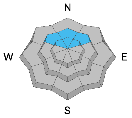
A CONSIDERABLE avalanche danger exists on steep northeast, north, and northwest facing slopes above about 9000'. Human triggered slab avalanches are likely in those locations. Keep slope angles under 30 degrees if you are traveling in this terrain and make sure there are no steep slopes directly above you.
Low
Moderate
Considerable
High
Extreme
Learn how to read the forecast here
Special Announcements
Get free batteries for your transceiver and a chance to win 1 of 10 Black Diamond Rescue Kits, 1 of 3 Mammut Barryvox transceivers, or 1 of 3 BCA Tracker transceivers. Stop at Big Pine Sports in Fairview or another participating shop, fill out our survey and get a free set of batteries. Don't need batteries, but still want a chance to win? Simply fill out the survey to be registered.
Weather and Snow
Current Conditions
The strong wind on Wednesday really stirred up the snow stripping it down to bare dirt on the higher westerly facing ridgelines. It has dramatically slowed down. Temperatures have warmed to around 20˚F.
Mountain Weather
A shortwave trough will move through Utah bringing snow but it will favor the norther part of the state. The Skyline should see some light snowfall with a couple of inches of new snow possible by Friday morning. The best chance for snow is later this afternoon into tonight. Wind today will be moderate from the west southwest this morning and slow as well as shift more northwest later today. Temperatures will drop into the single digits as the day goes on.
Recent Avalanches
No new avalanches have been reported but not many people were out recently either. I did receive a report from a rider who experienced some cracking around his machine.
Ad
Avalanche Problem #1
Persistent Weak Layer
Type
Location
Likelihood
Size
Description
A layer of weak sugary faceted snow from October is now buried under new snow from the past week. The weak faceted snow was left over from October in areas where it didn't melt out. This is mainly above about 9000' on northeast, north, and northwest facing slopes. This layer has produced slab avalanches, cracking and collapsing of the snowpack which are all bullseye clues to avalanche danger. This old layer of faceted snow is known as a "persistent weak layer" because it can persist for long periods of time producing avalanches during and after each storm. The only mitigation that works is to avoid steep slopes where this faceted snow exists.