Forecast for the Skyline Area Mountains

Issued by Brett Kobernik on
Sunday morning, December 15, 2019
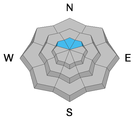
The avalanche danger is CONSIDERABLE in the upper elevation northwest through east facing terrain. Look for and avoid fresh drifts on any steep slope. On upper elevation steep northerly facing slopes, it is possible for a person to trigger an avalanche that breaks into weak sugar snow near the ground.

Low
Moderate
Considerable
High
Extreme
Learn how to read the forecast here
Avalanche Problem #1
Persistent Weak Layer
Type

Location

Likelihood

Size

Description
Even though we didn't receive all that much snow, the wind may have drifted enough snow to make the old weak sugar snow on the ground reactive again. My suspicions are things didn't get real dangerous but I was not able to get into the high terrain on Saturday to confirm this. Treat those high elevation northerly facing slopes as guilty until proven innocent.
Avalanche Problem #2
Wind Drifted Snow
Type

Location

Likelihood

Size

Description
Any fresh drifts that formed during the storm may still be sensitive today. Watch for "pillowy" looking drifts of snow and avoid them on steep slopes.
Additional Information
This forecast is from the U.S. Forest Service, which is solely responsible for its content. This forecast describes general avalanche conditions and local variations always occur.