Check out our Holiday Auction

Forecast for the Skyline Area Mountains

Brett Kobernik
Issued by Brett Kobernik on
Sunday morning, December 1, 2024
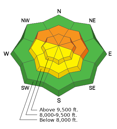
The overall avalanche danger is currently CONSIDERABLE.
The danger trend is decreasing meaning that each day it is becoming less likely to trigger an avalanche.
However, very weak snow still remains at that bottom of the snowpack. If provoked by humans, it is likely to fail and cause an avalanche.
Low
Moderate
Considerable
High
Extreme
Learn how to read the forecast here
Weather and Snow
Current Conditions: Saturday was another nice day in the mountains with good riding conditions and sunny skies. Temperatures along the highest terrain were around 30˚F overnight but much colder down in the canyon bottoms. This is known as an "inversion" and is very typical during a "ridge of high pressure" like we are transitioning into.
Mountain Weather: Another sunny day with temperatures into the mid to upper 30s is in store today. It looks like the wind should remain light today from variable directions. High pressure continues through the week although we may see some clouds on Monday. No significant storms are in sight.
Recent Avalanches
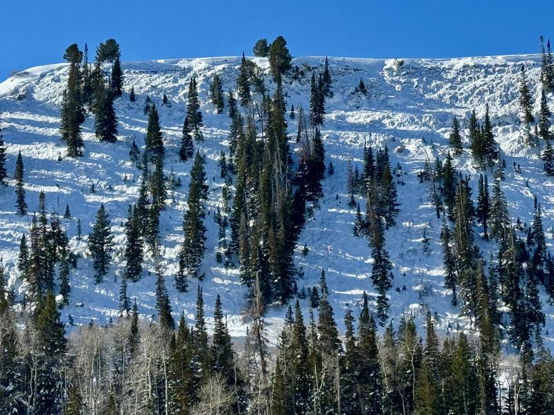
There was a large avalanche that released sometime since Thanksgiving day. It was in Scotty's which is in Ephraim Canyon. There was no significant weather event that would've caused it to release naturally so my hunch is it was triggered by a snowmobiler. Regardless of the trigger, this avalanche clearly demonstrates that we still have an unstable snowpack. Photo: Jayson Albee
Ad
Avalanche Problem #1
Persistent Weak Layer
Type
Location
Likelihood
Size
Description
We have an unstable snowpack structure with weak sugary snow near the ground (accumulated Oct through mid Nov) and a new dense slab of snow (accumulated pre-Thanksgiving) on top of it. This situation has produced avalanches and lots of cracking and collapsing. The recent avalanche in Ephraim Canyon confirms that the snowpack is still not stable. This weak sugary snow near the ground is what we call a "Persistent Weak Layer" because it can persist and stay weak for weeks or even months.
The most likely place to trigger an avalanche that breaks into this Persistent Weak Layer is in terrain above 8000 feet that faces west, north or east with northeast facing slopes being the most suspect. If you stick to slopes less than 30˚ in steepness, you will stay out of avalanche danger.
General Announcements
This forecast is from the U.S.D.A. Forest Service, which is solely responsible for its content. This forecast describes general avalanche conditions and local variations always occur.