Forecast for the Skyline Area Mountains

Brett Kobernik
Issued by Brett Kobernik on
Monday morning, January 9, 2023
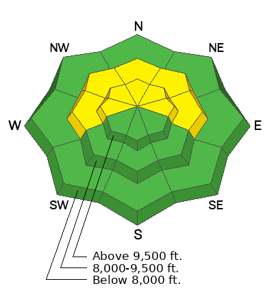
The overall avalanche danger is rated MODERATE today.
Chances for triggering a deep avalanche are becoming less likely.
Consequences remain quite severe if you do trigger one as it will be quite deep.
Low
Moderate
Considerable
High
Extreme
Learn how to read the forecast here
Weather and Snow
Current Conditions: Moderate speed wind from the south has stirred up the snow a bit in the more exposed terrain. Wind speeds are fairly light this morning. Dense soft snow can still be found in many locations. Temperatures are around 20˚F this morning.
Mountain Weather: Clouds will continue to build in ahead of a decent looking storm for the Skyline. Southwest wind speed will gradually increase today but won't get real strong. Snowfall starts tonight in a southwest flow and we should see 4 to 8 inches by Tuesday morning. Southwest wind looks like it's going to be pretty strong for a short period Tuesday morning. We'll have a break in snowfall during the day then another better looking period of snow late Tuesday into Wednesday which should bring another 6 to 10 inches.
Ad
Avalanche Problem #1
Persistent Weak Layer
Type
Location
Likelihood
Size
Description
An avalanche breaking into the old deeply buried November Persistent Weak Layer is really your only concern out there right now. The chances for triggering one are low, consequences remain high.
I have a zero tolerance policty for buried facets so I continue to stay off the steep terrain. My strategy is to wait for this next storm to move through and see if there are any natural avalanches that happen. If not, I'll be feeling quite a bit better and will probably start cautiously getting into some select steeper terrain.
General Announcements
This forecast is from the U.S.D.A. Forest Service, which is solely responsible for its content. This forecast describes general avalanche conditions and local variations always occur.