Join us at our 2nd Annual Blizzard Ball

Forecast for the Skyline Area Mountains

Brett Kobernik
Issued by Brett Kobernik on
Monday morning, January 6, 2025
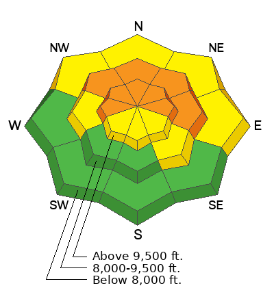
The overall danger rating is CONSIDERABLE today on the Manti Skyline.
The danger will gradually be decreasing over the next few days but there's still a good chance that a person could trigger an avalanche breaking into old weak faceted snow.
The most likely places to find trouble are slopes steeper than 30˚ above 8000 feet in elevation that face west, north and east.
Low
Moderate
Considerable
High
Extreme
Learn how to read the forecast here
Special Announcements
FREE AVALANCHE AWARENESS PRESENTATION!!
Big Pine Sports
340 N Milburn Rd, Fairview, UT 84629
Tuesday, January 14th, 7pm
Weather and Snow
Current Conditions: Wind is almost non-existent this morning and temperatures have been steady at around 20˚F. Saturday's storm delivered a nice little refresher and riding conditions are good.
Mountain Weather: We have a storm moving through today and into Tuesday that won't do much more than bring clouds and minor snow accumulations. High temperatures will get into the mid 20s. Wind will start to shift more northerly and will eventually be coming from the northeast on Tuesday. It looks like skies might clear out for the last part of the work week.
Ad
Avalanche Problem #1
Persistent Weak Layer
Type
Location
Likelihood
Size
Description
Unfortunately, we still need to be concerned about weak faceted snow layers deeper in the snowpack. These layers are still capable of producing dangerous avalanches on steep slopes that face west, north and east but especially northeast.
My partner and I were doing fieldwork around Huntington Canyon on Sunday and were still experiencing some collapsing (whumpfing) of the snowpack underneath us. This is a sure sign of unstable snow. The areas we were in are more shallow than a lot of areas on the Skyline. Shallow areas are almost always weaker areas. In places where it's deeper, we are probably not going to be seeing such obvious signs of unstable snow. But the faceted snow still remains and hasn't gained enough strength for me to trust getting into some of my favorite steeper terrain. The likelihood of triggering an avalanche is decreasing but the consequences remain the same.
.
General Announcements
This forecast is from the U.S.D.A. Forest Service, which is solely responsible for its content. This forecast describes general avalanche conditions and local variations always occur.