Forecast for the Skyline Area Mountains

Brett Kobernik
Issued by Brett Kobernik on
Thursday morning, January 6, 2022
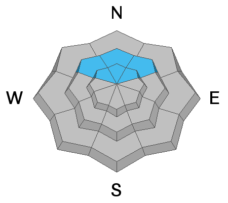
The avalanche danger remains CONSIDERABLE on mid and upper elevation northwest, north and northeast, and east facing slopes. Large human triggered avalanches are likely.
The snowpack is becoming more stubborn. It is slowly becoming less likely to trigger an avalanche. That said, you won't see me on any steep slopes on the north half of the compass.
Low
Moderate
Considerable
High
Extreme
Learn how to read the forecast here
Special Announcements
FREE AVALANCHE AWARENESS CLASS!!
Thursday, January 13, 7pm
Big Pine Sports, Fairview, Utah
Dinner provided!!

Come learn more about avalanche safety. Topics include:
  • How to read avalanche terrain
  • Basic snowpack structure knowledge
  • How to use the daily avalanche forecast
  • Overview of manditory safety gear (beacon, shovel, and probe) as well as air bag information
  • Q & A to help with any questions you may have
Weather and Snow
Current Conditions
We are in kind of an oddly warm weather pattern. The northern Skyline (north of Horseshoe Mtn) picked up 2 to 4 inches of dense snow on Wednesday. I'm not seeing any real accumulation south of Horseshoe Mountain. Temperatures were very warm and it rained in some locations up to 9500'. You will find a frozen rain crust in locations where it rained. The wind was pretty strong and is still blowing fairly strong along the ridges. Temperatures are hovering right around freezing at 9000'.
Mountain Weather
Today will be partly cloudy with ridgetop temperatures around 30. The wind will slow as the day goes on. Friday looks sunny with slightly warmer temperatures. A small storm will move through Saturday bringing a trace to a couple of inches of snow.
Ad
Avalanche Problem #1
Persistent Weak Layer
Type
Location
Likelihood
Size
Description
This warm weather should continue to help settle and stabilize the snowpack. The mid and upper portion of the snowpack looks very good. The facets (sugar snow) are still there near the ground and are still a concern. There was a snowpit test done on Wednesday where the facets would not fail and propagate. This is a good sign. We want to see this trend be widespread throughout the range and then we'll start feeling comfortable about the persistent layer of sugary facets.

Persistent Weak Layer Summary, 2021-2022:
There was a foot or more of snow that fell in October.
This snow melted away on many slopes but it stayed on northwest, north and northeast facing slopes above about 8500'.
The snow that stayed turned into a weak sugary layer during dry weather in November.
We saw a large amount of snow in December which landed on top of the weak snow from October.
The weak layer of sugary faceted snow collapsed and produced avalanches under the stress of the large storms.
The weak layer is still present. We are monitoring it and are hopeful it will become more stable with time.