Forecast for the Skyline Area Mountains

Brett Kobernik
Issued by Brett Kobernik on
Monday morning, January 3, 2022
The snowpack has gained some strength and is much more stubborn to someone triggering an avalanche but it remains dangerous.
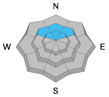
The avalanche danger is CONSIDERABLE on mid and upper elevation northwest, north and northeast, and east facing slopes. Large human triggered avalanches are likely.
Continue to avoid steep slopes on the north half of the compass until we are sure that the snowpack is stable.
Low
Moderate
Considerable
High
Extreme
Learn how to read the forecast here
Weather and Snow
Current Conditions
Sunday was another day with excellent riding conditions. You'll probably find a minor sun crust on southerly facing slopes from the sun heating those slopes on Sunday.
Mountain Weather
We'll see sun this morning with daytime highs in the upper 20s along the higher terrain. Clouds move in later. The next storm moving in on Wednesday may bring a few inches of snow but it looks like the majority of the energy will stay north of our region.
Ad
Avalanche Problem #1
Persistent Weak Layer
Type
Location
Likelihood
Size
Description
Our focus remains on the weak snow near the ground from October. This is buried under all the snow that fell in December. This layer has produced numerous natural avalanches. I'm starting to see it gaining some strength but it remains unstable and dangerous at this time. This problem is found on the north half of the compass. Shallow locations where the snowpack is 3 feet total depth or less are more unstable. Southerly facing slopes do not have this weak layer and are generally safe right now.