Forecast for the Skyline Area Mountains

Brett Kobernik
Issued by Brett Kobernik on
Friday morning, January 3, 2020
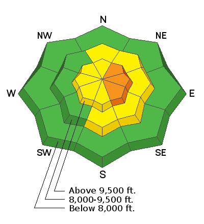
The avalanche danger is CONSIDERABLE on steep easterly facing slopes where the wind has formed fresh drifts of wind blown snow. Watch for large "pillowy" looking drifts and avoid them on steep slopes. Cracking within the snow is a sign of danger. The avalanche danger is much lower outside of wind affected terrain.
Low
Moderate
Considerable
High
Extreme
Learn how to read the forecast here
Weather and Snow
Yesterday: Snow showers continued on Thursday but didn't really accumulate much more. Storm totals are in the 8 to 10 inch range. Wind is the big factor. It's been pretty gusty in the higher terrain from a west northwest direction. For some more details, check out this excellent BACKCOUNTRY OBSERVATION from John Pikus.
Today: We'll see some clouds moving through but it looks like a fairly nice day in store. The ridgetop wind looks like it will continue to be a bit gusty from the northwest. Temperatures will get into the mid 20s.
Outlook: Saturday looks like another fairly decent day with partly cloudy skies and mild temperatures with highs around 30. The wind will shift around to the southwest and it looks like it's going to be a bit gusty along the ridgetops. Sunday starts out fairly nice with a chance for snow late in the day. I'm only expecting a trace to a couple of inches at this point.
Recent Avalanches
Visibility has hampered looking for natural avalanche activity during the storm. With some clear weather today, I'm expecting that we'll see some natural activity from during the storm in the form of wind drifted snow avalanches.
Ad
Avalanche Problem #1
Wind Drifted Snow
Type
Location
Likelihood
Size
Description
The wind has been blowing during this storm. Wind transports snow and forms large drifts especially along ridgelines. Often these will fail and avalanche during windy storms. These drifts can be sensitive to the weight of a person directly after storms as well. This is your main concern today. If you avoid steep terrain in the upper elevations where the wind has been forming drifts, you'll stay safe.
Additional Information
This forecast is from the U.S. Forest Service, which is solely responsible for its content. This forecast describes general avalanche conditions and local variations always occur.