Forecast for the Skyline Area Mountains

Brett Kobernik
Issued by Brett Kobernik on
Friday morning, January 22, 2021
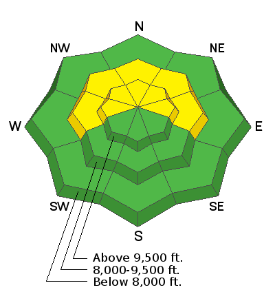
Today the avalanche danger remains MODERATE. Very steep upper elevation slopes are the most likely places for a person to trigger a small avalanche.
THE SNOWPACK IS VERY WEAK!! The avalanche danger will increase over the weekend if we get the anticipated amount of snow.
Low
Moderate
Considerable
High
Extreme
Learn how to read the forecast here
Weather and Snow
Current Conditions: Overnight temperatures were in the low 20s. The wind has been from the southwest and has been fairly light.
Mountain Weather: It looks like we're going to get a little snow late today and tonight. We'll see increasing clouds today with highs in the upper 20s and fairly light southwest wind which should increase a bit this afternoon. Bands of snow will move through starting late afternoon and we should see 4 to 8 inches by mid day Saturday. This storm has a southwest flow and also involves warm air advection. I find this situation a bit tricky to forecast. We'll see mostly cloudy skies through the weekend and another storm should move through Monday night bringing another decent shot of snow.
Ad
Avalanche Problem #1
Persistent Weak Layer
Type
Location
Likelihood
Size
Description
The snowpack has become very weak during this long stretch with no new snow. In many areas, the snowpack consists entirely of faceted, sugary snow. It is unsupportable and punchy. You punch right through to the ground with your boots in most locations. Even southerly facing slopes contain weak sugary snow. All the snow that's currently on the ground will act as a Persistent Weak Layer once we bury it with more layers of snow. Tonight's storm probably won't be enough to make things really dangerous. My thinking is that it will take a couple of new layers before we see things get really active. BOTTOM LINE: it is almost certain that the avalanche conditions will get dangerous as we add more snow.