Forecast for the Skyline Area Mountains

Brett Kobernik
Issued by Brett Kobernik on
Friday morning, January 15, 2021
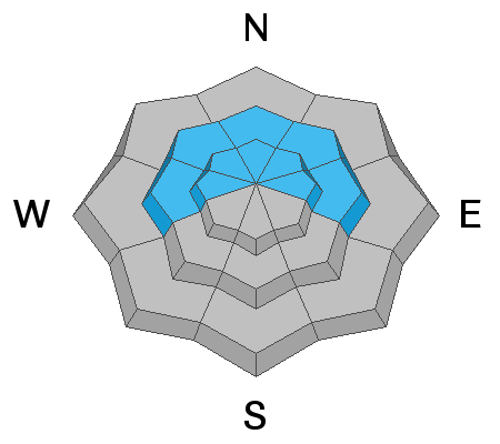
Human triggered avalanches remain possible due to freshly drifted snow on top of very weak sugary snow. The danger is MODERATE in the upper elevation northwest through southeast facing steep slopes. More east facing slopes have the most likely chance of avalanching. "Whoomping" noise from the snowpack and shooting cracks are red flags.
Low
Moderate
Considerable
High
Extreme
Learn how to read the forecast here
Weather and Snow
Current Conditions: Fairly strong wind still continues in the higher terrain but it looks like it has slowed in the mid elevations. The majority of the terrain now has crusts and hard drifts scattered about from the two days of consistent wind. Temperatures are mild in many locations with readings in the upper 20s. Drainage and canyon bottoms where cool are sinks have readings in the upper teens.
Mountain Weather: We have a nice day in store with lots of sun and mild temperatures getting into the low 30s. It looks like it will continue to be windy along the higher ridges again today. The next chance for snow is a minor storm on Monday. This looks pretty weak and I'm not expecting anything more than a trace to a few inches.
Ad
Avalanche Problem #1
Persistent Weak Layer
Type
Location
Likelihood
Size
Description
Wind drifts and crusts have formed in lots of places over the last few days. Many of these have formed on top of very weak snow. This enhances the chance for triggering an avalanche. The most likely places are on more east facing aspects since the west wind takes snow and deposits it on the east side of ridges.
The weak sugary snow is known as a Persistent Weak Layer. It remains weak for a long period of time. We will continue to deal with this for a long time to come.