Forecast for the Skyline Area Mountains

Brett Kobernik
Issued by Brett Kobernik on
Thursday morning, January 14, 2021
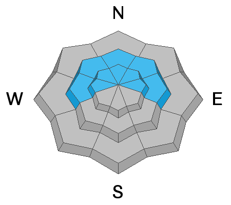
The avalanche danger remains CONSIDERABLE on steep upper elevation slopes that face northwest, north, east and southeast. Easterly facing slopes are the most likely places to trigger an avalanche today because of the strong wind drifting snow onto those slopes. Some westerly facing slopes will be stripped clean of snow but some will contain pockets of wind drifted snow that may be sensitive. Continue to avoid the described terrain to avoid getting caught in an avalanche.
Low
Moderate
Considerable
High
Extreme
Learn how to read the forecast here
Weather and Snow
Current Conditions: Strong northwest wind picked up on Wednesday and continued overnight with gusts over 50mph along the highest peaks. Temperatures dropped into the teens overnight. I can't imagine that there is much left in the way of decent riding conditions but I'll find out today during some fieldwork.
Mountain Weather: Strong northwest wind will continue again today and start to slow on Friday. We'll see sun with perhaps some high clouds and temperatures staying around 20˚F. Friday looks sunny with warmer temperatures. The next chance for snow is Monday as a small storm moves through which might bring a few inches.
Ad
Avalanche Problem #1
Persistent Weak Layer
Type
Location
Likelihood
Size
Description
Continued windy conditions today and the resulting drifted snow is the main focus. Many slopes contain weak sugary faceted snow known as a "Persistent Weak Layer". The new wind load on top of the weak faceted snow will make triggering an avalanche more likely. The most likely locations will be on more easterly facing slopes but continue to use caution on all aspects as the wind can erratically form drifts all over the place.