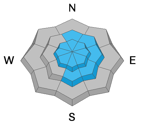
Current Conditions: Riding conditions are excellent right now in areas of untracked snow. You'll find 4 to 8 inches of new snow from the last few days. Backcountry travelers noted a few small fresh drifts that had either released or were prone to cracking. Temperatures were cold on Friday barely getting out of the single digits. They rebounded overnight and are around 20˚F this morning. Southwest wind has increased over the highest peaks. Off the ridges, the wind is currently pleasant.
Snowpack Discussion: Snowpack strength varies greatly depending on where you look. The snowpack in mid and lower Huntington Canyon has completely fallen apart and is just a pile of unsupportable sugary facets. It's currently not dangerous but once more snow stacks up on top of the existing weak snow we will most likely see avalanches. The good news is that not many people recreate in that terrain. The bad news is a road runs underneath a number of avalanche paths in that zone.
In stark contrast to Huntington Canyon, John Pikus traveled in Pleasant Creek where he found a mostly deep and stable snowpack structure. (see his excellent
BACKCOUNTRY OBSERVATION HERE) The snowpack is well consolidated without any significant weak layers within the pack. There are a few places where he found some weak snow but overall the structure looks good. I have found many areas along the Skyline with similar conditions. This is good news.
However, our good friend Pickle reported that he and his partners experienced a significant sudden collapse of the snowpack (WHOOMP) and felt it rapidly settle. This is mother nature telling us there is danger. This is a huge clue that there is weak snow deeper in the snowpack that could fail and produce an avalanche. This was on an east northeast facing slope at about 10,200'. You can bet that there are some other areas scattered across the range that have a similar snowpack structure.
So, what do we make of all this? Well, it's what avalanche professionals refer to as "spacial variability" This means that some areas are holding quite strong snow and some other areas are holding weak snow. It varies from place to place. This makes things tricky. I'd like to think that the majority of the terrain where we recreate has a stronger snowpack. On the flipside, some of these areas where we're finding weak snow make me nervous.
Weather: A series of storms is still on track to move through our region with the first one getting started today. We should see snowfall today especially this afternoon. I'm thinking we'll see 5 to 9 inches of snow by mid day Sunday. We may have already seen the high temperature for the day. I'm expecting mid to upper teens for the rest of the day. We'll see westerly winds that are a little blustery along the higher terrain but overall shouldn't be too unpleasant. The next impulse is Sunday night into Monday which should bring a few more inches. The next one after that is Tuesday into Wednesday which should also bring a few more inches.


