Join us at our 2nd Annual Blizzard Ball

Forecast for the Salt Lake Area Mountains

Drew Hardesty
Issued by Drew Hardesty on
Thursday morning, December 19, 2024
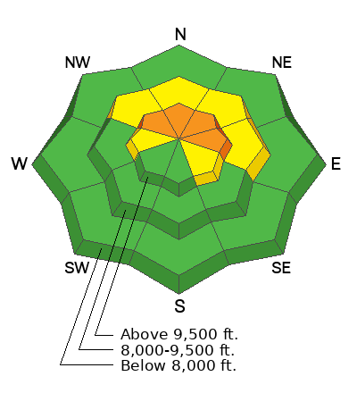
Areas of CONSIDERABLE avalanche danger exist, particularly on recently wind loaded westerly to northerly to easterly facing slopes of the upper elevations. Here, you can trigger an avalanche 1-3 feet deep and hundreds of feet wide, failing on a PWL (persistent weak layer) of sugary, faceted snow. A MODERATE danger exists in the mid-elevation bands. Know that you can trigger these from a distance. Know also that cracking and collapsing may not be there to provide any hints of danger.
***Many avalanche accidents occur under these conditions: sunny weather, easy travel, the snowpack full of landmines. I'm continuing to avoid being on or beneath steep polar aspects for the time being.
If you're in the high alpine terrain, look for a checkerboard of soft and hard wind slabs around terrain features and don't overlook the possibility of WET LOOSE SLUFFS with daytime warming.
Low
Moderate
Considerable
High
Extreme
Learn how to read the forecast here
Special Announcements
Now is a great time to dial in your safety gear including putting fresh new batteries in your beacons! Local shops across the state will be handing out free Batteries for Beacons now until February 1, 2025. All you need to do is fill out a quick survey and grab the AAA or AA batteries you need to keep your beacon fresh this season. Find participating shops and more info here.

Join the UAC and DPS Skis for a fun night of Avalanche Jeopardy this Friday, December 20th from 6:00 - 8:30 PM at Industry SLC. More information for this FREE event is available here. See you there!


HEADS UP! Park City and Canyons avalanche teams will be conducting avalanche work in McDonald Draw along the PC ridgeline (just north of the Monitors). Please avoid this area today. Thank you -
Weather and Snow
Skies are clear.
With high pressure overhead, we'll have sunny skies today with building temperatures inversions and diminishing westerly winds. As of 5am, temps are in the mid to upper 20s up high, the low 20s down low. Should be a nice couple of "spring" days right before the Winter Solstice: sunny skies, light winds and temperatures soaring to even the upper 30s to low 40s along the higher ridgelines and approaching 50°F (!) by tomorrow. Boy.
Still, skiing and riding conditions are not half bad in the sun and wind sheltered terrain although coverage remains thin.
The Outlook: A weak storm is slated for late weekend into Monday that may produce a couple inches of snow. The weather models tease of a more progressive storm track between Christmas and New Year's. We'll see.
Recent Avalanches
On Tuesday, two significant avalanches were triggered in the backcountry.
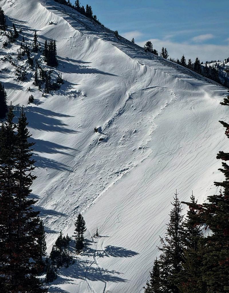
  • The first was intentionally triggered from the safety of the ridgeline along Main Days. This avalanche peeled out 2 feet deep and 80 feet wide on a very steep northeast facing slope at 10,500', failing on our PWL (persistent weak layer) of early season weak faceted grains. As it turns out, this avalanche was just getting started, as this initial avalanche dominoed north, sympathetic'ing more avalanches along the way. Estimated width of all the avalanches is 800 feet. See Joey Manship's photo below.

  • The second looked to be a very close call near Scott Peak along the south end of the PC ridgeline. Details are hazy, but it appears two tracks in and two tracks out. This party triggered a heavily wind loaded pocket 2 feet deep and 70 feet wide that also failed on our PWL of early season faceted grains. (photo Mark White). This avalanche was on a northeast facing slope at 9800'.


We didn't hear of any avalanches in the backcountry yesterday, but ski area control teams continued to trigger pockets of stubborn hard slab in the high alpine. Backcountry observers also find a talkative snowpack with collapses and whumphs more common than not.
Ad
Avalanche Problem #1
Persistent Weak Layer
Type
Location
Likelihood
Size
Description
We have a nasty persistent weak layer (PWL) of faceted grains near the bottom of the snowpack. (There is also another, more spotty, weak layer of facets and/or surface hoar within the upper foot of snow.). This bottom layer of weak, sugary faceted grains are - in many locations - sitting uneasily underneath last weekend's snow and wind...just waiting for a trigger. These are Landmines that are sure to kill you, or darn near close. Take another look at the avalanches above. The mechanics of this structure allow for these avalanches to be triggered remotely (at a distance) and are completely unmanageable. The most likely place to trigger one would be on steep westerly to northerly to easterly facing aspects on wind-loaded terrain of the upper elevations. There's no question that we're all hungry for powder, but you have to ask yourself, What will happen if it slides? Your beacon, helmet or airbag may not be enough.
A couple of excellent observations from yesterday:
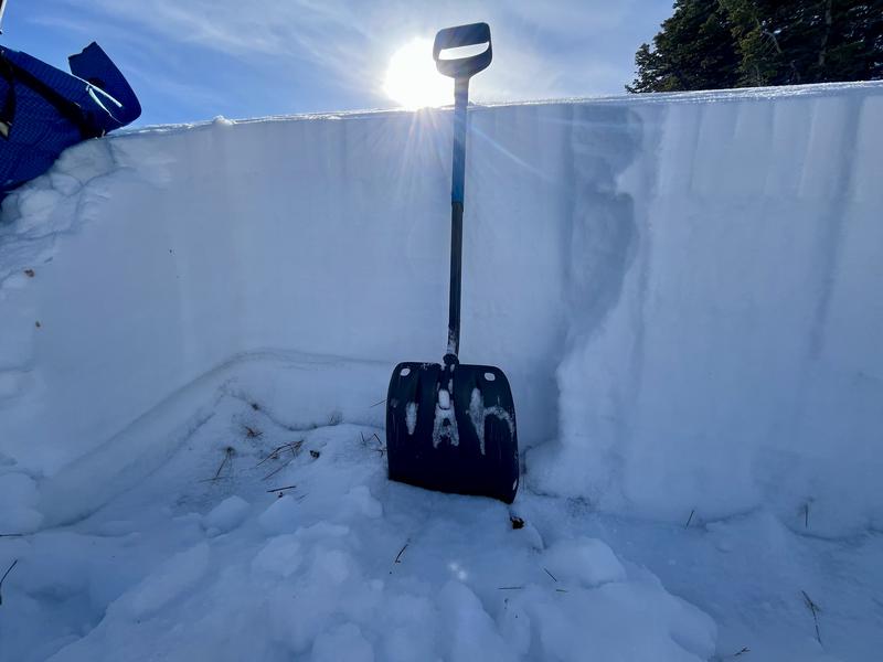
McKinley Talty's report from the Park City ridgeline (see snow profile below: easy to see the slab over weak layer structure)
Will Ambler's report from White Pine of LCC; he writes, "Whumph whumph whumph all day as we broke trail off the main white pine road. Some with obvious shooting cracks."
Additional Information
Forecaster Corner: LANDMINES
One of the greatest satisfactions of my career is having conversations with others about this world. With permission, I am reprinting a recent piece of correspondence from an Army officer - Derek Telleson - who is frequently deployed to the middle east.
I spent time in the middle east as a naval intelligence officer in Desert Storm in the early 90s.
General Announcements
This information does not apply to developed ski areas or highways where avalanche control is normally done. This forecast is from the U.S.D.A. Forest Service, which is solely responsible for its content. This forecast describes general avalanche conditions and local variations always occur.