


Forecast for the Salt Lake Area Mountains

Issued by Trent Meisenheimer on
Saturday morning, January 25, 2025
Saturday morning, January 25, 2025
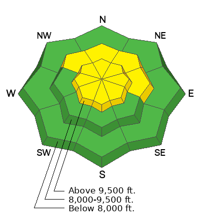
Areas of MODERATE avalanche danger exist on all aspects at the upper elevations and on mid-elevation aspects facing northwest through north and east where it is possible to trigger a hard slab avalanche of wind-drifted snow 1-2 feet deep.
On northerly and east-facing slopes at the mid and upper elevations, there is a MODERATE danger of triggering an avalanche that fails 2-4 feet deep in a persistent weak layer.
Low
Moderate
Considerable
High
Extreme
Learn how to read the forecast here
 Special Announcements
Urgent battery replacement required for anyone who received batteries from one of our participating "Batteries for Beacons" shops. Please review the "Batteries for Beacons" replacement notice on our blog. Batteries distributed through our "Batteries for Beacons" program this year have shown to be inadequate length.
Join the UAC at Deer Valley on January 30th for the 2nd Annual Blizzard Ball Gala. Bruce Tremper, the Former Director of the Utah Avalanche Center, will deliver the keynote address.
 Weather and Snow
Overnight the mountains picked up 1 to 3 inches of new snow (0.05-0.14 inches of water). The wind has been pretty calm all night and currently blows from the west-southwest at speeds of 5-10 mph across the upper elevations. Mountain temperatures range from 10-20 °F.
As a cutoff low forms over California, we should continue to see light snowfall throughout the day, with perhaps an additional 1 to 6 inches of new snow if we are lucky. The wind will oscillate from south to southeast blowing 10-15 mph across the higher terrain. Mountain temperatures will climb into the mid-20s °F.
Unfortunately, strong winds from the past week have wreaked havoc on our snow surface. It's a moonscape out there in places. Hard drifts of wind-blown snow have been scattered throughout the terrain. Yesterday, I found soft settled powder in the protected wind-sheltered terrain, but it was limited. Today's snowfall should help the overall riding conditions.
 Recent Avalanches
On Thursday, a skier was caught and carried in an avalanche along the Park City Ridgeline on a run called Katie's. The avalanche was on a north-facing slope at 9,700' and was a hard slab of wind-drifted snow. It was 1 to 2 feet deep and 300 feet wide and ran into some nasty trees. The skier did sustain some injuries but will be okay.

Avalanche Problem #1
Wind Drifted Snow
Type
Location
Likelihood
Size
Description
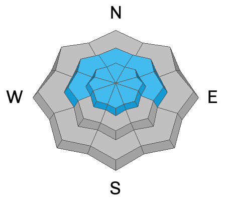
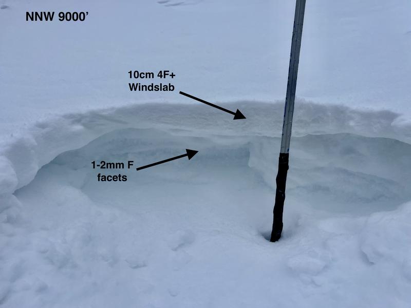
Strong wind from the past week has created hard slabs of wind-drifted snow in many areas. These slabs formed over our faceted snow surface making them a bit more tricky. Yesterday, while investigating Thursday's human-triggered avalanche, I was able to get propagating results in my snowpit tests. This tells me these slabs are still reactive, and human-triggered avalanches remain possible.
You can find these wind slabs well off ridgelines and on all aspects, but more commonly on slopes facing north through east. Be on the lookout for wind slabs today, and remember, hard wind slabs allow you to get well out onto a slope before fracturing, often even above you.
Photo: Grainger / Anderson showing the wind slab over weak faceted snow.
Avalanche Problem #2
Persistent Weak Layer
Type
Location
Likelihood
Size
Description
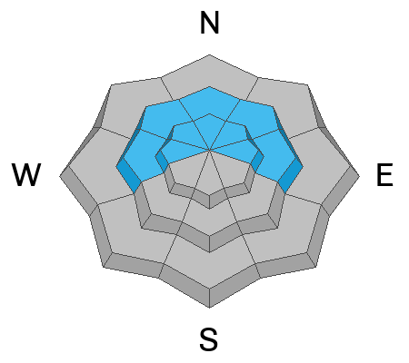
The problem we have this winter is we aren't getting consistent snowfall. Days and days of cold clear weather back in November and December caused our base to become weak and faceted. Over Christmas, we loaded this weak layer (storm snow), and two people tragically died from this setup. As the snow settled and adjusted, this weak layer became more and more used to the weight above, and therefore, it's becoming harder and harder to trigger. Especially when we haven't seen another loading event. The last avalanche we saw on this layer was January 16th.
To add insult to injury, we haven't had much snow since the New Year. I count five small storms with 13 nights of clear and cold weather that faceted the snow surface, perhaps making our next weak layer. Yes, we will see large and dangerous avalanches again, especially when we load our snowpack with more weight. But for now, we wait.
For me, there is too much faceted snow in the snowpack to trust it. I do not like faceted snow. It's unpredictable and scary. I am going to remain patient and continue to avoid steep slopes facing the north side of the compass for the foreseeable future. If you choose to ride that terrain, set yourself up for success and consider the consequences (like trees). Travel one at a time and avoid steep, shallow, rocky terrain where it is more likely to trigger a deeper slab avalanche 2-4 feet deep.
Additional Information
Be sure to read Nikki's Week in Review as a regular part of your backcountry planning.
General Announcements
This information does not apply to developed ski areas or highways where avalanche control is normally done. This forecast is from the U.S.D.A. Forest Service, which is solely responsible for its content. This forecast describes general avalanche conditions and local variations always occur.