Join us at our 2nd Annual Blizzard Ball

Forecast for the Provo Area Mountains

Trent Meisenheimer
Issued by Trent Meisenheimer on
Sunday morning, April 18, 2021
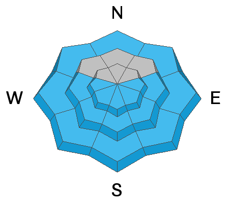
The avalanche danger will rise to MODERATE for wet loose avalanches as the day heats up. If the snow surface is becoming damp and wet, it's time to leave or change your aspect. Do not overstay your welcome on steep, sunlit slopes today.
The avalanche danger is MODERATE at the upper elevations for wind drifted snow avalanches. Look for and avoid steep slopes that the wind has loaded.

Today is the last regularly scheduled avalanche forecast for the season. We will issue updates with any measurable snowfall through the rest of April but will not issue danger ratings. Please continue sending in observations as we will post those daily. Thank you!
Low
Moderate
Considerable
High
Extreme
Learn how to read the forecast here
Weather and Snow
Under clear skies, the mountain temperatures are currently in the low 20's °F across the board. Unfortunately, the northeast winds did pick up in the overnight hours, with speeds averaging 10-15 mph across the upper elevation terrain. This morning the northeast winds continue to blow 10-15 mph with gusts to 25 mph. At 11,000', the northeast winds are blowing 15-20 mph, gusting 31 mph.
High pressure will dominate the weather over Northern Utah today, with plenty of sunshine and temperatures climbing into the 43-47 °F range at 8,800 feet today.

Our final Week in Review for the 2020/21 season - where we summarize significant weather and avalanche events for the prior week - has been published.
Recent Avalanches
Yesterday was a fairly active day in the mountains for wind slab avalanche activity. Three different but notable avalanches led to people being caught and carried - be sure to check out the reports; two are from the Provo area. HERE. Thank you to everyone for submitting these observations and being open and honest.
Ad
Avalanche Problem #1
Wet Snow
Type
Location
Likelihood
Size
Description
The warming from the sun will start on the easterly aspects this morning, and the wet activity will follow as the sun moves to the south and eventually sets in the west. As the snow surface becomes damp and wet, I would expect long-running wet loose avalanches that could run fast and far today, especially in places where the snow can funnel, like in a chute or gully.
If the snow surface is damp or wet, and you see active roller balls - it's time to leave or change your aspect. Don't overstay your welcome. Today is not the day to ride a steep, sunlit slope late in the day.
Keep in mind that even the low elevation northerly terrain can be wet and could produce avalanches as you exit the upper elevation terrain.
Avalanche Problem #2
Wind Drifted Snow
Type
Location
Likelihood
Size
Description
The northeast winds picked up overnight and are now averaging 10-15 mph with gusts to 25 mph across the upper elevation terrain. With new snow to move around and the recent avalanche activity reported yesterday, I would expect wind slabs to be reactive today.
The issue with northeast winds is that they load slopes in unusual ways that we are not always used to seeing. Keep an eye out for hard or soft drifts of wind-blown snow today, and avoid those areas. Look for and avoid rounded, pillowy, stiff hollow-sounding snow.
General Announcements
Please visit this website with information about Responsible Winter Recreation by the Utah Office of Outdoor Recreation.

This information does not apply to developed ski areas or highways where avalanche control is normally done. This forecast is from the U.S.D.A. Forest Service, which is solely responsible for its content. This forecast describes general avalanche conditions and local variations always occur.