Join us at our 2nd Annual Blizzard Ball

Forecast for the Provo Area Mountains

Trent Meisenheimer
Issued by Trent Meisenheimer on
Saturday morning, April 17, 2021
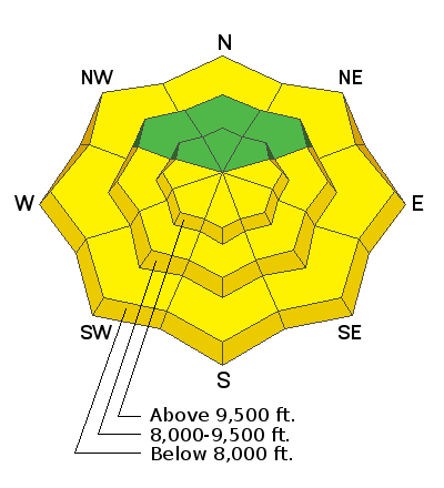
Today the avalanche danger will quickly rise to MODERATE for wet loose avalanches. If the snow surface is becoming damp and wet, it's time to leave or change your aspect. Do not overstay your welcome on steep sunlit slopes today.
Human-triggered wet loose avalanches are possible and could be large enough to bury a human, especially in a terrain trap, like a chute or gully.
Low
Moderate
Considerable
High
Extreme
Learn how to read the forecast here
Special Announcements
Sunday, April 18th will be the 163rd avalanche forecast and the last one for the 2020/2021 season. For the rest of the month of April, we will provide updates on the snow and weather anytime it snows which is hopefully a lot. We will also continue to post observations.
Weather and Snow
Under clear skies, the mountain temperatures are 18-25 °F across the range. As the storm exits to our east, the winds also veered to the east as high pressure takes hold for the weekend. Currently, the winds are blowing 10-15 mph with gusts into the upper teens at many of the upper elevation wind sites. At 11,000', the winds are blowing east-northeast 10-15 mph gusting in the low 20's.
Unfortunately, the powder party will come to a close as today we will see the strong April sun. Mountain temperatures will climb into the upper 30's to low 40's °F at 8,800'. Winds will be from the east and north and will continue to blow in the 10-20 mph range at ridgetop. The good news is the upper elevation temperatures stay relatively cold for this time of year. Today's forecast for 700 Millibars (10,000') temperatures are as follows:
12:00 pm = 19 °F
3:00 pm = 23 °F
6:00 pm = 25°F

Our final Week in Review for the 2020/21 season - where we summarize significant weather and avalanche events for the prior week - has been published.
Recent Avalanches
Since Wednesday, there have been several small new snow avalanches reported to the UAC and you can see all those observations HERE. Yesterday, there were no significant avalanches reported.
Ad
Avalanche Problem #1
Wet Snow
Type
Location
Likelihood
Size
Description
The April sun will instantly warm the snow surface today. The warming from the sun will start on the easterly aspects this morning, and the wet activity will follow as the sun moves to the south and eventually sets in the west. As the snow surface becomes damp and wet, I would expect long-running wet loose avalanches that could run fast and far today, especially in places where the snow can funnel, like in a chute or gully.
I would think these avalanches have the potential to be large enough to bury a person. If the snow surface is damp or wet, and you see active roller balls - it's time to leave or change your aspect. Don't overstay your welcome. Today is not the day to ride a steep, sunlit slope late in the day.
If you're riding cold, dry snow with no wind affect the avalanche danger is LOW. If you're riding wet, damp, soggy snow, the avalanche danger is MODERATE for wet loose avalanche issues.
Keep in mind that even the low elevation northerly terrain can be wet and could produce avalanches as you exit the upper elevation terrain.
General Announcements
Please visit this website with information about Responsible Winter Recreation by the Utah Office of Outdoor Recreation.

This information does not apply to developed ski areas or highways where avalanche control is normally done. This forecast is from the U.S.D.A. Forest Service, which is solely responsible for its content. This forecast describes general avalanche conditions and local variations always occur.