Join us at our 2nd Annual Blizzard Ball

Forecast for the Provo Area Mountains

Greg Gagne
Issued by Greg Gagne on
Friday morning, April 10, 2020
The avalanche danger is LOW, but could possibly rise to MODERATE due to warming of the snowpack. Travel in avalanche terrain during the springtime can be complicated, and today's concerns include (1) wet avalanches on all aspects as the snow surface warms throughout the day and (2) large cornices breaking back farther than expected along the ridgelines.
Pay attention to rapidly-changing springtime conditions.
Low
Moderate
Considerable
High
Extreme
Learn how to read the forecast here
Special Announcements
The Avalanche Research Program at Simon Fraser University is conducting an online survey to examine how people use avalanche safety information. They want to hear from all backcountry users to understand how they process information provided in public avalanche forecasts. Anyone who completes the survey before May 15th will be entered to win cash prizes.
Uncertainty, Risk, & Decision Making: before, during, and after COVID-19 - Read this thought-provoking blog post about how we take risks by guest author Tom Diegel.
Weather and Snow
Currently: With the arrival of Thursday's cold front, temperatures dropped below freezing last evening for the first time in 36 hours, and are currently in the upper 20's and low 30's F. Winds are very light (less than 10 mph) and skies are clear. Very light rain fell late yesterday afternoon, up to at least 8,500'. With clear skies and a solid refreeze overnight, the snow surface should be locked up tightly this morning.
Today: Sunny and mild. Temperatures will rise into the 40's and winds will be from the south/southeast and remain light, with gusts only reaching the low teens.
This Weekend: Winds will increase Saturday ahead of a cold front, with colder temperatures and unsettled weather into the early part of this coming week. Accumulations will be minor, however.
Recent Avalanches
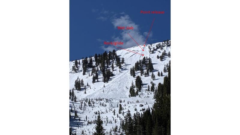
No backcountry avalanche activity was reported from the Provo mountains on Thursday. In the Salt Lake mountains, a natural wet slab avalanche was reported from Porter Fork in Millcreek Canyon on Thursday (observation). This was on a northeast aspect at 9,500'. It was 3' deep and 150' wide.
Also in the Salt Lake mountains, several glide avalanches were reported Wednesday, including Stairs Gulch and in Broads Fork on Bonkers and Blue Ice.
Glide avalanches occur when a previously open glide crack releases and the entire snowpack slides as a unit to the ground. While these tend to be unpredictable, multiple occurring within a small time frame indicates conditions are currently suitable for these to release.
Find the full observation page HERE.
Ad
Avalanche Problem #1
Normal Caution
Type
Location
Likelihood
Size
Description
The overall avalanche danger is LOW, possibly rising to MODERATE this afternoon due to warming of the snowpack. In general, wet avalanche activity is managed most effectively by timing - once the snow surface becomes wet and sloppy, it is time to move to a shadier aspect. Watch for signs of wet, loose snow including rollerballs and sluffing in the wet snow.
However, avalanche concerns in the spring can become complicated, and two other concerns to watch for today include:
1. Wet Slabs - Wet slab avalanches occur when meltwater from rain or warm temperatures percolate down through the snowpack and weaken the bonds (strength) of a buried weak layer. These avalanches can be human-triggered, but also occur naturally, including triggering from a small, wet-loose avalanche or cornice fall. (See Thursday's Porter Fork wet slab as Exhibit A.) Colder temperatures should lock up the snowpack this morning, but strong sunshine today could provide enough warming to trigger isolated wet slabs. These could occur on any aspect facing west, south, through east, as well as northerly aspects up to about 10,000'.
2. Cornices - Cornices in some places are massive, and they can break off naturally, especially during warm weather when they start bending downhill. Simply avoid being underneath or near the tops of large cornices as they break farther back than expected.
Additional Information
Information on outdoor recreation - The State of Utah created this webpage with information about recreating on both state and federal public lands during the current health crisis.

Skiing and riding at closed ski resorts - Some resorts allow access now, and some do not. Please check HERE for the latest info on ski area access.

New to the backcountry (including riding at closed resorts) - Watch the award-winning, 15 minute Know Before You Go video, or take the 5-part, free online-learning series.
General Announcements
This information does not apply to developed ski areas or highways where avalanche control is normally done. This forecast is from the U.S.D.A. Forest Service, which is solely responsible for its content. This forecast describes general avalanche conditions and local variations always occur.