Join us at our 2nd Annual Blizzard Ball

Forecast for the Provo Area Mountains

Trent Meisenheimer
Issued by Trent Meisenheimer on
Sunday morning, March 28, 2021
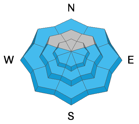
Today the avalanche danger will rise to MODERATE on east, south, and west-facing steep terrain as the snow surface becomes wet. Look for the obvious signs of wet snow: Roller-balls and pinwheels cascading down the slope will be the first sign that the snow is becoming wet and unstable, and it's time to get out of there.
There is also a MODERATE avalanche danger across all upper-elevation steep terrain for the possibility of a small wind slab avalanche. Always be on the lookout for wind drifted snow in the alpine and in extreme terrain.
Low
Moderate
Considerable
High
Extreme
Learn how to read the forecast here
Special Announcements
The 2021 Spring Awareness Campaign is underway. Please help us save lives through avalanche forecasts and education. Consider donating to show your support HERE.
Test your avalanche forecast comprehension skills by taking this short quiz after you read the forecast. Forecast quiz HERE. Click HERE to learn why we are asking you to take this quiz.
Weather and Snow
This morning under clear skies, the mountain temperatures hover 25-31°F across the range. Winds have backed to the west and increased in the past few hours and are currently blowing 25-30 mph gusting to 40 mph at 11,000'. Across many of the upper-elevation ridgelines (~10,000'), the wind blows 10-15 mph gusting into the low 20's mph. Below about 9,500 winds are variable and are in the 5-10 mph range.
There will be plenty of sunshine today, and temperatures will warm into the upper 30's and low 40's °F at 9,000'. Winds should stay about the same before increasing later this evening as a splitting storm is ushered in for Monday and Tuesday. Many aspects and elevations will be crusted this morning as yesterday's strong sun, and warm temperatures melted the upper snow surface. Mid and upper-elevation slopes facing northwest, north, and northeast will hold settled dry snow.

Our Week in Review - where we highlight significant snow and avalanche events from this past week - has been published.
Recent Avalanches
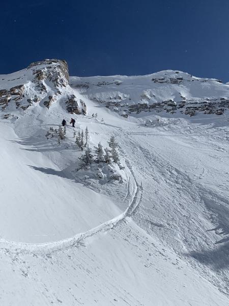
No new observations from the Provo Mountains yesterday. Yesterday, as the sun heated the snow surface, we went through a widespread small wet loose avalanche cycle on slopes facing east through south through the west. One skier in the Central Wasatch was caught and carried (pic below) in a small wind slab avalanche on a south-facing slope at 11,000' in elevation. The avalanche was 8 inches deep, 30 feet wide, and they were caught and carried about 50 feet before self-arresting.
Ad
Avalanche Problem #1
Wet Snow
Type
Location
Likelihood
Size
Description
Another round of strong sunshine and warming temperatures will heat the snow surface, and wet loose avalanches will become possible this morning and throughout the day. Perhaps yesterday, this happened as the sun first hit the dry snow in the early morning. Today, it will take a little longer for the sun to heat the snow surface as the snow surface this morning is frozen and crusted over.
Look for clues that the snow surface is heating up. First, it will become damp and slightly wet, followed by roller-balls and pinwheels cascading downhill. At this point - it's time to get out of there or head to colder aspects. Don't overstay your welcome on steep, sunlit slopes.
Avalanche Problem #2
Wind Drifted Snow
Type
Location
Likelihood
Size
Description
Yesterday's wind slab avalanche off the SLC Twins is enough to make me think about small wind slab avalanches today. These wind slabs will be small and relatively harmless in terrain with clean run-outs and/or where you won't be carried for hundreds of feet downhill. Remember that even a small avalanche in steep exposed terrain can have severe consequences if you're taken off your feet and carried over rocks and cliffs. Always be on the lookout and avoid the stiff/hollow sounding or pillowy and rounded snow.
General Announcements
Please visit this website with information about Responsible Winter Recreation by the Utah Office of Outdoor Recreation.

This information does not apply to developed ski areas or highways where avalanche control is normally done. This forecast is from the U.S.D.A. Forest Service, which is solely responsible for its content. This forecast describes general avalanche conditions and local variations always occur.