Forecast for the Provo Area Mountains

Nikki Champion
Issued by Nikki Champion on
Friday morning, December 27, 2019
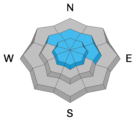
A MODERATE DANGER remains for human triggered sluff and storm slab avalanches on all upper elevation aspects and northwest through east-facing slopes at mid-elevations. Human triggered avalanches are possible.
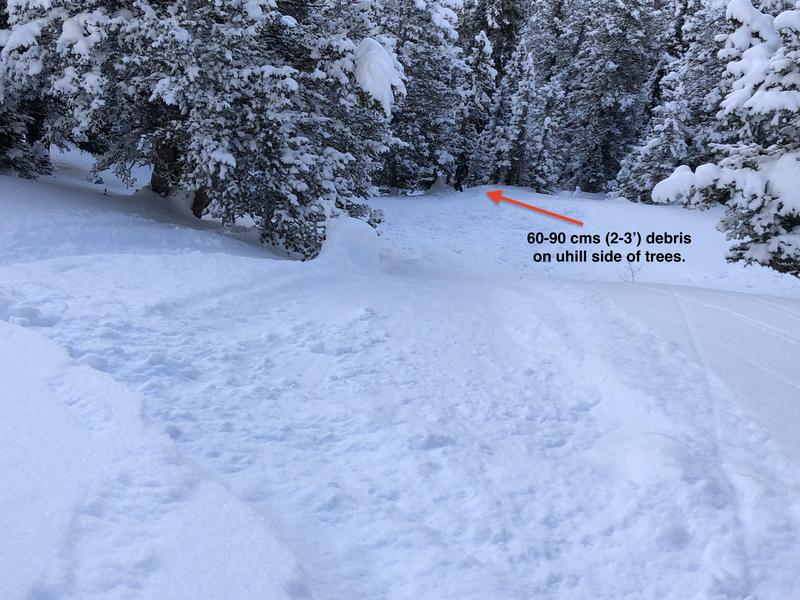
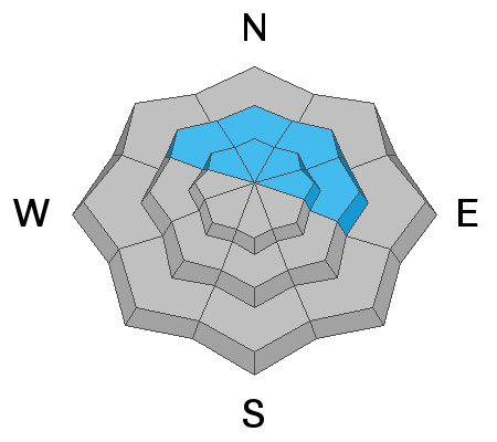
An isolated MODERATE DANGER ALSO EXISTS for triggering an avalanche 2-5' deep on northwest through east facing aspects. Continue to avoid steep rocky terrain as well as shallow slopes that have already avalanched this season.
The Fine Print - If the winds pick up earlier than expected OR we see more sun than forecast, the new snow will be more sensitive in steeper terrain .
Low
Moderate
Considerable
High
Extreme
Learn how to read the forecast here
Special Announcements
New blog post-Landmines -
With permission, I am reprinting a recent piece of correspondence from an Army officer who is frequently deployed to the middle east.

New podcast - Risk, Reward, and the Big Lie - A Conversation with Ski Guide Doug Workman

Jenna Malone's UAC Podcast - Betting Your Life - Why Forecasting is Poker and Not Chess - A Conversation with Jenna Malone - now has her video presentation from this fall's USAW.

Thanks to the generous support of our Utah ski resorts and Ski Utah, we have discount lift tickets available. All proceeds from these go towards paying for avalanche forecasting and education! Get your tickets here.
Weather and Snow
This morning trailhead temperatures are in the mid-teens F, and ridgetop temperatures are in the low teens F. Easterly winds are easterly, blowing 10-15mph.
Since yesterday morning, the mountains picked up another 1" of snow bringing storm totals in the Central Wasatch to 10-16", and 4-7" in the Provo area mountains.
Today, temperatures should be cool in the upper teens and low 20s F. The winds will remain calm and skies will be overcast into the afternoon. This evening winds should increase from the north northwest and bring a few scattered showers into Saturday morning.
Recent Avalanches
No reports of activity from the Provo mountains yesterday, but widespread sluffing and isolated soft slabs were noted in steeper terrain in the Central and northern Wasatch.
Across the board, these sluffs were generally running in the old-snow interface on a bed surface comprised of temperature crusts and wind old slabs. The photo below shows a ski cut on a 45-degree rollover which resulted in a sluff moving downhill and depositing 60-90 cms (2-3') of snow on the uphill side of trees. See the whole observation HERE which goes into a greater discussion on ski cutting and terrain choice.
Ski cut debris on a steep slope. PC- G. Gagne . Video of close call in the Canyons backcountry of Dutch Draw from two days ago.

Ad
Avalanche Problem #1
New Snow
Type
Location
Likelihood
Size
Description
Human triggered point release and new snow avalanches remain possible on all aspects at upper elevations and northwest through east-facing aspects at mid-elevations. With a wide variety of surface conditions before this most recent storm, these avalanches have a variety of weak interfaces to break on. This new snow instability will be most suspect on upper elevation and north-facing terrain that has been preserved by the cool temps and lack of winds.
The Fine Print:
  • If winds increase into the afternoon, at the uppermost elevations shallow soft slabs of wind drifted snow could begin to form. Look for signs of wind loading and avoid that terrain.
  • If we see more sun than expected, the new storm snow will become more active on the steepest sunlit slopes.
These slides are most problematic in steep, sustain terrain where the sluff and storm snow debris may pile up deeply or above-exposed rocky terrain that being knocked off your feet isn't an option.
There's generally little mystery with these types of avalanches: they break at your feet or sled and respond to cornice drops and ski cuts. Keep an eye on your partners; carry and know how to use your rescue gear.
Danger Trend: Steady to Decreasing
Avalanche Problem #2
Persistent Weak Layer
Type
Location
Likelihood
Size
Description
We still have a potentially unstable snow structure of a strong slab over a very persistent weak layer of faceted snow near the ground on mid and upper elevation northwest through east facing terrain.
Overall this layer continues to present itself as dormant, giving no signs of avalanche activity for over a week, but it is not gone nor is it forgotten. Recent wind and snow has added a touch more stress to these basal weaknesses, but in isolated areas. While we are getting closer to seeing the absolute dormancy of this layer, we need more time.
Yesterday Mark and I targeted the Shale Shot area off the Park City Ridgeline where we found obvious facets at the ground and we were able to get propagation only with very hard hits of our shovel. This area best represents the most suspect slopes for this persistent weak layer, very rocky places or places with a thin snowpack (less than a ski pole in depth). While out traveling look for signs of a shallow snowpack by probing the depth with your ski pole or probe.
If you choose to enter the terrain where this avalanche problem exists, look at the terrain below you and consider the consequences of triggering one of these large avalanches.
Below is a photo representing the soft and shallow snowpack on top of the weak facets on the ground found in more suspect terrain of the Central Wasatch PC: Champion
Danger Trend: Steady to Decreasing

General Announcements
This information does not apply to developed ski areas or highways where avalanche control is normally done. This forecast is from the U.S.D.A. Forest Service, which is solely responsible for its content. This forecast describes general avalanche conditions and local variations always occur.