Special Avalanche Bulletin
What: Heavy snowfall and drifting by strong winds will cause dangerous avalanche conditions to develop this weekend in the mountains of northern Utah.
When: In effect from 6 am MST this morning through 6 am Monday: For the mountains of Northern Utah, including the Wasatch Range...Bear River Range... and Western Uinta Mountains.
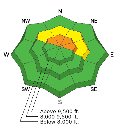
Impacts: Pre-existing, weak, faceted snow is widespread on northerly-facing slopes at upper and mid elevations, and dangerous avalanche conditions will develop on many slopes. People are likely to trigger avalanches by being on or below slopes steeper than 30 degrees. Avalanches could be triggered remotely (from a distance) or from below.
Warning Times: Saturday, December 14, 2024 - 6:00 am to Sunday, December 15, 2024 - 6:00 am
Within the past 36 hours, the mountains received a nice new coat of white paint. Snow totals range from 5 to 9 inches (0.23-0.93 water), with the 5 inches at Aspen Grove and the 9 inches at Sundance Mountain.
This morning, the southerly wind has picked up ahead of an approaching storm. Current wind speeds are from the southwest, blowing at 15-20 mph with gusts into the 20s and 30s across the upper elevation terrain. Mountain temperatures are also rising and range from 25-31 °F.
Today, we can expect warm air advection (warming temperatures) and strong southerly winds ahead of two small storms. The first piece of the storm should impact northern Utah late this morning, and we should see some snowfall starting around 11 a.m. Throughout the day, we could see anywhere from 2 to 5 inches of new higher-density snowfall. We could also see locally higher amounts in areas favored by a southwest flow.
We should see a brief lull in snowfall this afternoon as the first storm exits and the next arrives. However, the wind should increase from the southwest, averaging 15-30 mph with gusts into the 30s, 40s, and 50s across the upper elevations for the next 24 hours. The next wave of the storm will move in this evening, and we should see temperatures drop and snow densities decrease into Sunday. All said and done, we could see 4-8 inches (0.50-0.80 water) of new snow by Sunday morning.
None. Today will likely be a different story.


