Forecast for the Provo Area Mountains

Drew Hardesty
Issued by Drew Hardesty on
Saturday morning, December 14, 2019
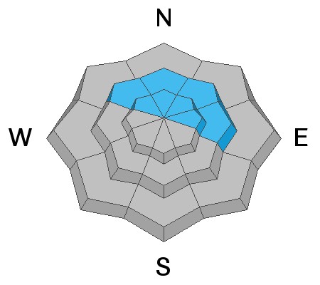
A HIGH DANGER exists in the upper elevations, particularly on steep northwest to east facing slopes. A CONSIDERABLE danger exists at the mid elevations. Any new snow avalanches may step down 2-3' deep into older weaker snow on northwest to east facing slopes at the mid and upper elevations and may be unsurvivable.

The key to safe riding today is to simply avoid being on or underneath any slopes 30 degrees or steeper. Fortunately, the dense snow provides excellent riding conditions on low-angled, wind-sheltered terrain.
Low
Moderate
Considerable
High
Extreme
Learn how to read the forecast here
Special Announcements

Thanks to the generous support of our Utah ski resorts and Ski Utah, we have discount lift tickets available. All proceeds support the UAC. Get your tickets HERE.

Consider taking an avalanche class, there are many different options. Click on the Education menu for a full list of classes from the UAC and other providers. Check out the Know Before You Go eLearning program for free, online, avalanche classes.

New UAC podcast: Betting Your Life (Why Forecasting is Poker and Not Chess) - A Conversation With Jenna Malone.
Weather and Snow
Skies are overcast with light snow falling in the Provo mountains. Overnight snow totals are 4-6" with storm totals of nearly a foot with 1.5"SWE. Over 2" of snow-water equivalant is reported at some weather stations. Winds are westerly blowing 10-15mph with gusts to 20. Along the highest ridgelines, winds are likely 30mph with gusts to 60. Snow depths are up to 3.5' in the mid-elevations. For today we'll see off and snow with 3-6" expeceted with temps in the upper 20s. Winds west to northwest 15-20mph.
Recent Avalanches
Several larger natural avalanches in the storm snow were reported yesterday on Timpanogos yesterday.
Ad
Avalanche Problem #1
Persistent Weak Layer
Type
Location
Likelihood
Size
Description
Dangerous avalanche conditions exist at the mid and upper elevation northwest through east facing slopes where any new snow avalanche may step down to near the ground. These will be 2-3' deep and hundreds of feet wide and are not to be trifled with. These may be triggered from a distance and are completely unmanageable except through proper terrain choices and avoidance.
Click on the button below for more details on how this layer formed and where you can find it.
TRAVEL ADVICE: Stay off of and out from underneath steep northwest to east facing terrain.
Avalanche Problem #2
New Snow
Type
Location
Likelihood
Size
Description
New snow avalanches may be triggered on many steep slopes at the mid and upper elevations and running on crusts formed earlier in the week. Cracking and collapsing, particularly in wind drifted terrain, are signs of instability.
Additional Information
Avalanche Rescue is the real deal. You must feel completely confident that you can pull off an avalanche rescue if things go wrong today. Even this may not save the day as roughly 1/4-1/3 of all fatalities are due to traumatic injury. If there is an avalanche accident, CALL 911 and say this is a backcountry emergency. But make no mistake - YOU NEED TO PULL OFF THE RESCUE, AND MOST LIKELY YOU HAVE ONLY 15-20 MINUTES TO DO SO.
KNOW THAT RESCUE TEAMS ASSUME A GREAT DEAL OF RISK in coming in to help injured or avalanched parties. AS ALWAYS, PLEASE OBEY CLOSURES AND UPHILL POLICY RESTRICTIONS AS INDICATED BY SKI AREAS AND UDOT.
General Announcements
This information does not apply to developed ski areas or highways where avalanche control is normally done. This forecast is from the U.S.D.A. Forest Service, which is solely responsible for its content. This forecast describes general avalanche conditions and local variations always occur.