Join us at our 2nd Annual Blizzard Ball

Forecast for the Provo Area Mountains

Nikki Champion
Issued by Nikki Champion on
Saturday morning, January 2, 2021
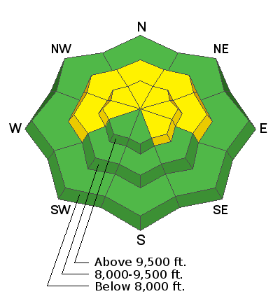
The avalanche danger is MODERATE on steep mid and upper elevation slopes facing west through north and east as well as upper-elevation southeast aspects. Human-triggered avalanches are possible on these slopes, especially if they have a denser slab of wind-blown snow on top of weaker, faceted snow. These avalanches may be triggered remotely and from lower-angled terrain below.
All other aspects have a LOW avalanche danger.
Low
Moderate
Considerable
High
Extreme
Learn how to read the forecast here
Special Announcements
The Utah Avalanche Center podcast's second episode of season 4 is live - Managing Risk with Avalanches, Managing Risk with a Pandemic - A Conversation with state epidemiologist Dr. Angela Dunn.
Stream here or tune in wherever you get your favorite podcasts

There are several new blogs that have recently been published:

Thanks to the generous support of our local resorts, Ski Utah, and Backcountry, discount lift tickets are now available. Support the UAC while you ski at the resorts this season. Tickets are available here.
Weather and Snow
This Morning, skies are partly cloudy with a temperature inversion in the mountains, temperatures range from the low teens F at trailheads to upper teens F near ridgelines. Winds are currently southwesterly and generally light, but gusting near 30 mph at 11,000' and near 20 mph at mid-elevations.
Today, expect partly cloudy skies with temperatures rising into the low 30s F. Winds will be from the west and begin increasing throughout the day as a weak disturbance passes to the north of us. Winds will be 10 to 20 mph at mid-elevations, with gusts up to 25 mph and gusts up to 35 mph at upper elevations. A trace amount of snow is possible throughout the day.
The few inches of snow received earlier this past week have greatly improved riding conditions, especially on lower-angled slopes above 8500'. Although we have a thin snowpack, it is generally supportable and providing decent riding and travel. Below 8500', the snow surface became damp yesterday as a thick cloud of fog swallowed up lower elevations and I would expect that snow surface to be frozen this morning.

Our Week in Review for Dec 25-31 has been published. Catch up on the significant weather and avalanche events from this past week.
Recent Avalanches
No new avalanches were reported in the Provo area yesterday but in the Central Wasatch, two new avalanches were reported in the backcountry:
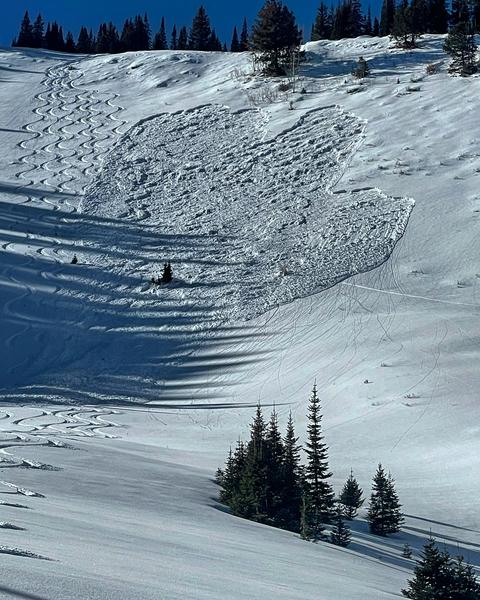
No Name Bowl. 9400'. East Aspect. Skier triggered soft slab on the persistent weak layer 12" down. Broke 300' above the skier, 150' wide, and ran 500' in total. Read Pro Observer Mark White's entire avalanche report HERE.
Chicken S#!T Ridge/Days Draw. 9500'. Northeast Aspect. Skier triggered soft slab on the persistent weak layer 1.5' down. Broke 10' wide, and ran 50'. We have seen quite a few human triggered avalanches in this area over the past few weeks. Find the entire avalanche report HERE.
Both of these avalanches are a reminder that human-triggered avalanches in specific areas are possible with a moderate avalanche danger. Find more about the danger scale HERE.
Photos of the No Name Bowl Slide. Photo: Mark White.
I encourage you to routinely read the excellent observations submitted to the UAC - it is our engaged community that makes us the envy of avalanche centers throughout the world.
Ad
Avalanche Problem #1
Persistent Weak Layer
Type
Location
Likelihood
Size
Description
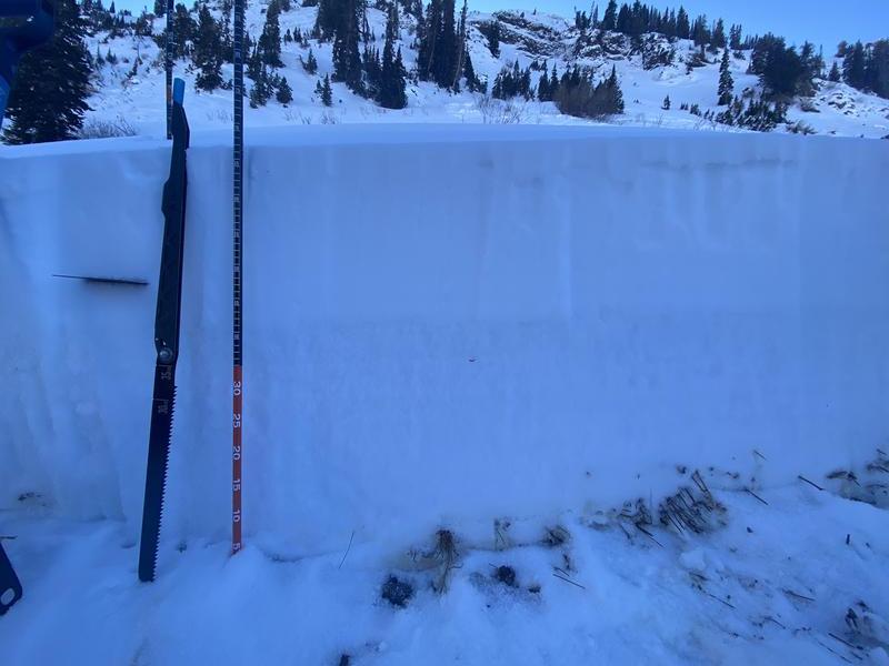
The dominant avalanche problem this season continues to be the persistent weak layer of weak faceted snow in the bottom half of our snowpack. Every forecaster that went out yesterday noted the same weak snowpack structure in their travels, you can see a photo below from Trent's pit in Mineral Fork that illustrates the widespread pattern of stronger snow (a cohesive slab) on top of the weaker faceted snow.
While the likelihood of triggering an avalanche is decreasing, avalanches are still occurring which is a reminder that the poor snowpack structure still exists and is still very weak. Outside of the two avalanches reported yesterday, we are still getting reports of widespread cracking, collapses, and propagation in extended column tests. Today, triggering an avalanche that fails on the persistent weak layer remains possible on slopes facing northwest through east at the mid and upper elevations. The most likely place to trigger an avalanche will be slopes that have been loaded from a few of the stronger wind events this past week and have a stronger slab on top of the weak facets.

Trent's photo from Mineral Fork illustrates the strong cohesive snow (the bright white snow) atop the weak faceted grains (the more grey snow). This is the snowpack structure that we are seeing across the range on primarily north and easterly facing terrain.
What are your options for dealing with this persistent weak layer? Today, you've got two options:
- Ride slopes less steep than 30 degrees;
- Ride slopes facing south where this persistent weak layer generally doesn't exist and avoid pockets of wind drifted snow. These slopes don't have much snow but have become much more supportable.
Be patient, folks, we're going to be dealing with this issue for some time. In the video below Greg shares some thoughts on dealing with our current poor snowpack structure and how it relates to danger ratings. Remember, with a moderate avalanche danger human triggered avalanches are still possible:

With a bump in winds this afternoon, if there are any signs of drifting snow, such as obvious transport, cracking, and pillow-shaped snow, avoid those slopes. Triggering an avalanche that initially fails in the wind-drifted snow will likely break down more deeply into the weak faceted snow below.
General Announcements
Please visit this website with information about Responsible Winter Recreation by the Utah Office of Outdoor Recreation.

This information does not apply to developed ski areas or highways where avalanche control is normally done. This forecast is from the U.S.D.A. Forest Service, which is solely responsible for its content. This forecast describes general avalanche conditions and local variations always occur.