Forecast for the Moab Area Mountains

Eric Trenbeath
Issued by Eric Trenbeath on
Monday morning, March 31, 2025
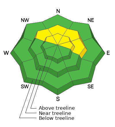
An isolated or MODERATE danger remains for human triggered avalanches failing on a buried persistent weak layer. This is a low probability, high consequence scenario. You are mostly likely to encounter this problem on steep, northerly aspects right around treeline and in isolated areas above. You can minimize your exposure by avoiding shallower snowpack areas, steep convexities, and rocky, radical terrain.
A few shallow fresh wind slabs were observed in the high country yesterday. We may see more developing today. Not large enough to bury you, they could sweep you off your feet and take you for a ride on the slick, hard surface underneath.
Low
Moderate
Considerable
High
Extreme
Learn how to read the forecast here
Special Announcements
Construction continues on the Loop Road Mon-Fri. It will be closed near Pack Creek from 8:30-5:30.
Geyser Pass Road: The road is melted down to the dirt.
Grooming Conditions: Grooming is done for the season.
Weather and Snow
6 A.M. Snow and Weather Data
24 Hour Snow: 0" 72 Hour Snow: 2" Season Total Snow: 123" Depth at Gold Basin: 44"
Winds on Pre-Laurel Peak: N/A Temp: 29° F
Weather
Mountain temperatures are about 10° warmer then yesterday but we still got a good refreeze. Southwest winds overnight blew in the 10-15 mph range with gusts in the 20's. They'll be on the increase today ahead of a strong storm system and cold front that will move into the area this evening. Look for increasing clouds today with strong southwest winds blowing 25-35 mph with gusts as high as 50 mph. Temperatures will climb into the low 40's. Light snow should begin after midnight with continued windy conditions. The main event happens tomorrow although areas slightly north are favored. Winds will continue to crank and we could see 3-5 inches of snow.
General Conditions
The snow surface is pretty solid out there and Dave and I found travel to be fast and easy yesterday. We were even pleasantly surprised to find decent dust on crust conditions on smooth slopes. Last week's warm weather and recent cold nights have locked up the snowpack and made it more difficult to trigger an avalanche. Melt water has penetrated the snowpack to varying depths depending on aspect and elevation but cold, dry snow remains underneath on northerly aspects above about 11,000'. Snowpack depths vary widely. While many southerly aspects are thin or completely bare, anywhere from 4 to 8 feet of snow can be found on northerly aspects. Areas of concern remain in shallower snowpack areas on steep, northerly aspects right around treeline where layers of dry, faceted snow still exist beneath a slab.
Snowpack and Weather Data
Gold Basin SNOTEL site (10,000')
SNOTEL site near Geyser Pass Winter Trailhead (9600')
Wind Station on Pre-Laurel Peak (11,400')
NWS forecast for the La Sal Mountains.
Recent Avalanches
A snowboarder triggered a large and dangerous avalanche on Horse Head Bowl in the Abajo mountains Saturday. We are extremely grateful for a positive outcome and his thorough and thoughtful report.
In our travels yesterday, Dave and I came across several wet slabs that ran during the heatwave including this large D3 R2.5-3 avalanche in upper Talking Mountain Cirque.
See the complete avalanche database here.
Ad
Avalanche Problem #1
Persistent Weak Layer
Type
Location
Likelihood
Size
Description
Warm temperatures, percolating meltwater in the snowpack, and several nights with a solid refreeze have significantly decreased the likelihood for triggering an avalanche on a persistent weak layer. However, layers of cold, dry faceted snow still remain on steep, northerly aspects near treeline, and in some areas above. Shallower snowpack areas are where you are most likely to find trouble and any avalanche triggered would be deep and dangerous. You can pull out your probe to determine snowpack depth. If you are finding depths of a 180 cms or more, you are probably okay but remember that shallow trigger points exist. Likely trigger points include steep convexities, thin slab margins, and shallow rocky areas. Sticking to broad, planar slopes will help minimize your risk.
Additional Information
Check out the latest UAC podcast with forecaster Brett "Kowboy" Kobernick where he discusses faceted persistent weak layers and how "nobody is immune from getting killed in an avalanche."
Sign up for text alerts to get the most up to date information about changing conditions, road plowing, special avalanche announcements.
Follow us on Instagram @utavy_moab
General Announcements
This forecast is from the U.S.D.A. Forest Service, which is solely responsible for its content. This forecast describes general avalanche conditions and local variations always occur.