Forecast for the Moab Area Mountains

Eric Trenbeath
Issued by Eric Trenbeath on
Sunday morning, March 30, 2025
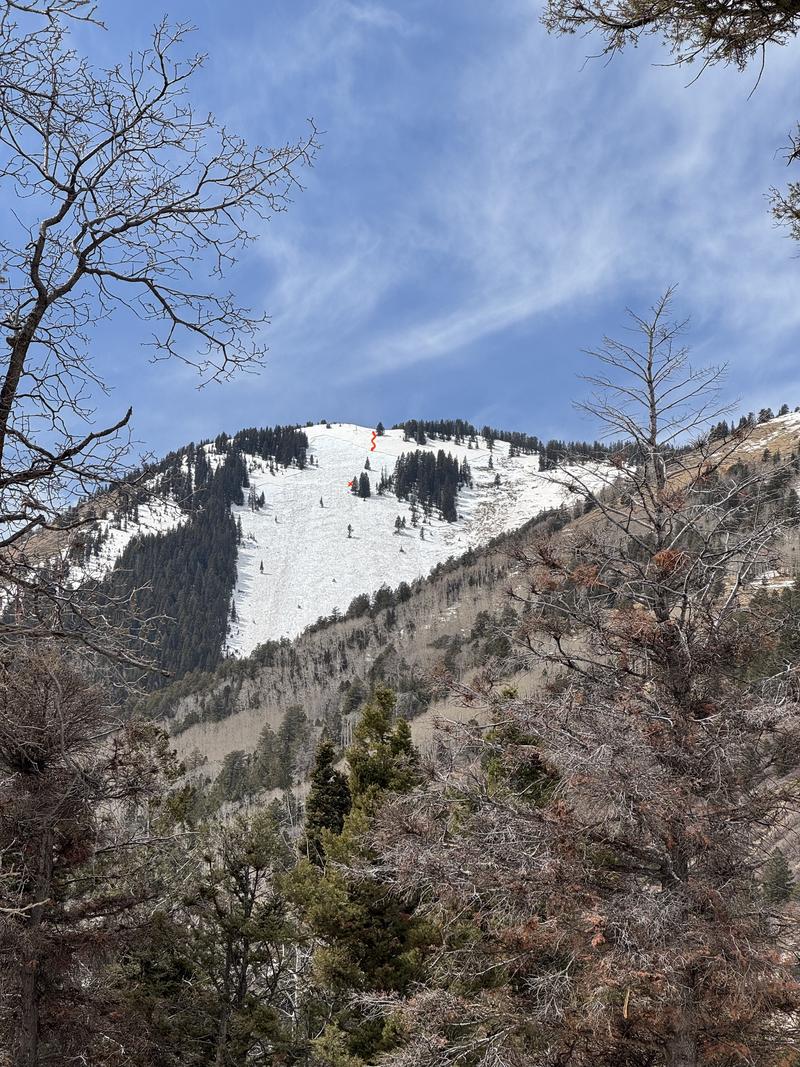
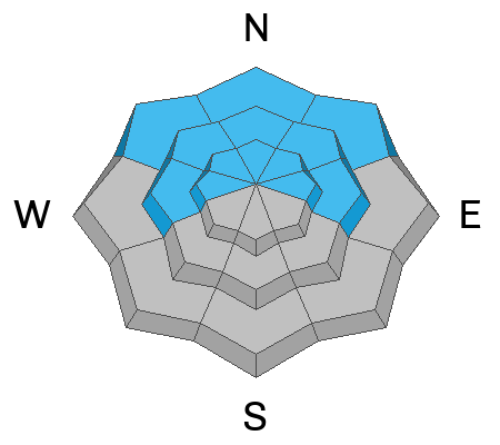
A MODERATE danger remains for human triggered avalanches failing on a buried persistent weak layer. This is a low probability, high consequence scenario. You are mostly likely to encounter this problem on steep, northerly aspects right around treeline and in isolated areas above. Warm temperatures this past week and a solid freeze overnight have greatly decreased the likelihood on west, and on lower elevation northerly aspects. Although not out of the question, I suspect we have turned the corner in these areas.
A few inches of new snow won't affect the danger much but you may encounter some very shallow sensitive soft slabs of wind drifted snow on upper elevation northerly aspects, as well as some loose snow sluffing on slick surfaces in very steep terrain.
Low
Moderate
Considerable
High
Extreme
Learn how to read the forecast here
Special Announcements
Construction continues on the Loop Road Mon-Fri. It will be closed near Pack Creek from 8:30-5:30.
Geyser Pass Road: The road is melted down to the dirt.
Grooming Conditions: Grooming is done for the season.
Weather and Snow
6 A.M. Snow and Weather Data
24 Hour Snow: 2" 72 Hour Snow: 2" Season Total Snow: 123" Depth at Gold Basin: 44"
Winds on Pre-Laurel Peak: N/A Temp: 17° F
Weather
Winter returns with 2 inches of new snow and sub 20° temperatures. High clouds this morning will gradually turn to mostly cloudy skies later today as the next shortwave trough moves over the region. There's a very slight chance for snow showers this afternoon although the system is quite weak and headed mostly north. Moderate ridge top winds will blow from the southwest and high temperatures will be in the mid to upper 30's. Monday will be mostly cloudy and breezy with increasing southwest winds ahead of a stronger system moving in from the Pacific Northwest. Although favoring points north, we should pick up a few inches of snow on Tuesday. Unsettled weather remains through the week.
General Conditions
With a couple inches of new snow and a well frozen surface beneath, look for bone chattering dust on crust conditions this morning. Your best bet for good turning and riding will be to find terrain that is smooth underneath and low angle. Warm temperatures last week have affected the snowpack in a variety of ways. Many south through westerly aspects are bare and the mountains from town look more like May. Existing snowcover, especially at lower elevations, has begun the transition toward a spring time snowpack while layers of cold, dry, faceted snow still exist on mid to upper elevation northerly aspects. In these areas, the threat remains for triggering a deep and dangerous avalanche. In fact, two snowboarders triggered a large and potentially life threatening avalanche in the Abajo Mountains yesterday. The avalanche failed on a persistent weak layer on a NE aspect at 11,100'. This remains the bullseye area of concern in the La Sals, and although increasingly unlikely, any avalanche triggered would be very high consequence.
Snowpack and Weather Data
Gold Basin SNOTEL site (10,000')
SNOTEL site near Geyser Pass Winter Trailhead (9600')
Wind Station on Pre-Laurel Peak (11,400')
NWS forecast for the La Sal Mountains.
Recent Avalanches
Large, snowboard triggered avalanche on Horse Head Bowl in the Abajo mountains yesterday.
See the complete avalanche database here.
Ad
Avalanche Problem #1
Persistent Weak Layer
Type
Location
Likelihood
Size
Description
Very warm temperatures, percolating melt water, and a solid overnight refreeze are helping to consolidate and strengthen the snowpack but we aren't out of the woods yet as yesterday's large avalanche in the Abajos can attest. The likelihood for triggering an avalanche on a persistent weak layer has decreased significantly, particularly on west, and lower elevation northerly aspects, but layers of cold, dry faceted snow still remain on steep, northerly aspects near treeline, and in some areas above. Any avalanche triggered would be deep, large, and dangerous. Likely trigger points are steep convexities, thin slab margins, and shallow rocky areas.
Additional Information
Check out the latest UAC podcast with forecaster Brett "Kowboy" Kobernick where he discusses faceted persistent weak layers and how "nobody is immune from getting killed in an avalanche."
Sign up for text alerts to get the most up to date information about changing conditions, road plowing, special avalanche announcements.
Follow us on Instagram @utavy_moab
General Announcements
This forecast is from the U.S.D.A. Forest Service, which is solely responsible for its content. This forecast describes general avalanche conditions and local variations always occur.