March Kicks Off Our Spring Campaign- Donate Now to Support Forecasting

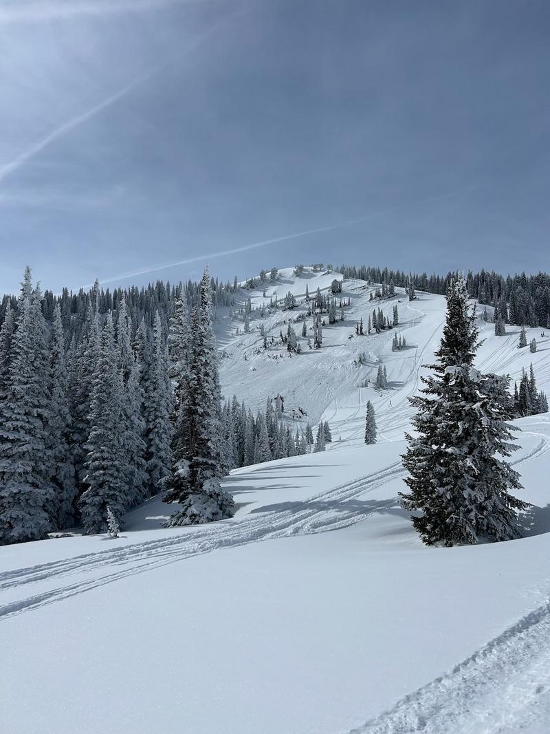
Forecast for the Moab Area Mountains

Dave Garcia
Issued by Dave Garcia on
Tuesday morning, February 25, 2025
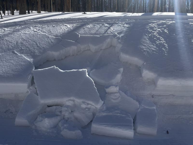
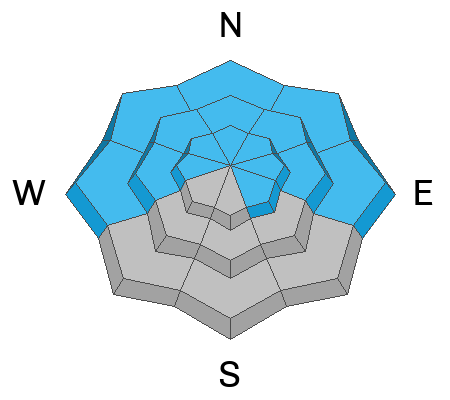
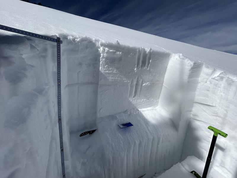
A CONSIDERABLE avalanche danger exists on steep, northerly aspects near treeline. In these areas, human-triggered avalanches 2 feet deep or more, failing on a persistent weak layer of faceted snow are likely.
The danger is MODERATE on all other slopes facing W-N-E, and on upper elevation, SE aspects, and human-triggered avalanches failing on this weak layer remain possible, to highly possible, especially on steep northerly aspects. Below treeline slopes are equally suspect, and poor snowpack structure exists here as well.
There is a MODERATE danger for wet-loose avalanches on slopes that face W-S-E. This problem is most pronounced on slopes that face SW and S. Look out for signs of wet activity as the day heats up.
Low
Moderate
Considerable
High
Extreme
Learn how to read the forecast here
Special Announcements
Geyser Pass Road: The road is plowed to the winter trailhead. It remains slick and snow packed. AWD and good tires recommended. Expect sloppy and muddy conditions later this afternoon.
Grooming Conditions: All trails were last groomed on Friday.
Weather and Snow
6 A.M. Snow and Weather Data
24 Hour Snow: 0" 72 Hour Snow: 0" Season Total Snow: 82" Depth at Gold Basin: 38"
Winds on Pre-Laurel Peak: N/A Temp: 35° F Percent of Normal (SWE): 69%
Weather
Under cloudy skies this morning, it is already 35° F in Gold Basin. Westerly winds will blow 10-15 MPH with gusts up to 25 MPH. Cloud cover will decrease throughout the day, and this afternoon should be mostly sunny. High temperatures will be well above normal, with a high of 44° F expected today. Temperatures will drop 10-15° F tomorrow, and winds will shift to the NW and remain elevated. Plenty of sunshine is on tap for the rest of the week, and temperatures will slowly climb back up to the low 40s F by the end of the week.
General Conditions
It has been over ten days since the Valentine's Day storm built a thick, cohesive slab on top of a very weak snowpack structure. Recent warm temperatures have increased the density of the overlying slab. Outward signs of instability like cracking and collapsing have diminished. You may not see any major red flags out there today, but keep in mind, the underlying snowpack is very weak. Many slopes that face W-N-E hang in the balance just waiting for a trigger, don't let it be you. Deep hard slab avalanches remain possible to likely on these slopes. These are potentially deadly, season-ending avalanches. One strategy is to keep your slope angles to less than 30 degrees or head to solar aspects. With today's warm temperatures, the solar aspects might offer some fun, spring-like skiing. If you are traveling on the sunny side, be aware of signs of wet avalanche activity as the day heats up.
Yesterday I traveled to Colorado Bowl to investigate weak snow on the shady side of the compass, be sure and read my latest observation here.
Eric spotted this snowmobile triggered slab on a steep road cut on Sunday. This is what we call a test slope. If you observe this kind of thing, it's an obvious red flag.
Snowpack and Weather Data
Gold Basin SNOTEL site (10,000')
SNOTEL site near Geyser Pass Winter Trailhead (9600')
Wind Station on Pre-Laurel Peak (11,400')
NWS forecast for the La Sal Mountains.
Recent Avalanches
See the avalanche database here.
There is a lot of yellow, or moderate danger on our rose right now. Moderate does not mean good to go, and human-triggered avalanches are possible. Check out this avalanche from the Logan area mountains just a few days ago. This is a great example of an avalanche that can happen at moderate danger.
Ad
Avalanche Problem #1
Persistent Weak Layer
Type
Location
Likelihood
Size
Description
The Valentine's Day storm has built a dense, cohesive slab on top of our weak, underlying snowpack. Outward signs of instability such as collapsing and whumphing are isolated at this point, but stability tests remain active. My recent tests yesterday show that avalanches can fail on multiple different weak layers, and easily step down to the weak facets below, creating a very deep and dangerous avalanche. Avalanches that step down could take out the entire season's snowpack. The bottom line is that human-triggered avalanches up to 2 feet deep or more, failing on this weak layer remain highly possible. The danger is most acute on northerly and easterly aspects near treeline, but slopes below the treeline harbor the same poor snowpack structure. Travel advice is to avoid any slope steeper than 30 degrees where this problem exists.
As you wrap around to the west, the problem still exists and it's a fine line between shady and sunny. Many westerly aspects still present as northerly if there are trees to provide shade. West facing slopes should be considered guilty until proven innocent, and a slope by slope analysis is required.
There are multiple faceted weak layers in our snowpack to be concerned about. On this east facing slope, the failure occurred 2.5' deep.
Avalanche Problem #2
Wet Snow
Type
Location
Likelihood
Size
Description
As the day heats up, we will see an increasing likelihood for wet avalanche activity. The mountains got a solid overnight refreeze, but high temperatures in the 40s° F and strong sunshine should be enough to cause some wet loose avalanches today. This problem will be most pronounced on slopes that face south and southwest. Signs of wet activity are roller balls, pinwheels, wet sloppy snow, and deep boot penetration on solar aspects. If you observe these signs, it is time to change aspects or go home.
Additional Information
In the video below, Eric describes "one of the worst snowpack structures he has ever seen." I agree with him completely, and I am avoiding avalanche terrain on any slope that holds poor structure. This will likely be my mindset until spring. Some seasons you just can't touch steep terrain, and this may be one of those years.
Check out the latest edition of the UAC podcast with Moab forecaster Dave Garcia where he talks about the challenges of forecasting for our remote and isolated range with limited information.
Sign up for text alerts to get the most up to date information about changing conditions, road plowing, special avalanche announcements.
Follow us on Instagram @utavy_moab
General Announcements
This forecast is from the U.S.D.A. Forest Service, which is solely responsible for its content. This forecast describes general avalanche conditions and local variations always occur.