Forecast for the Moab Area Mountains

Issued by Eric Trenbeath on
Saturday morning, February 25, 2023
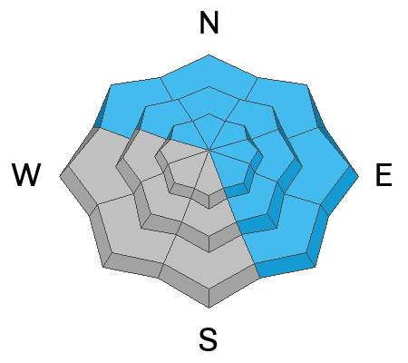
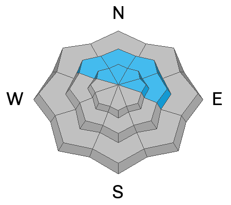
The avalanche danger remains CONSIDERABLE on steep slopes near and above treeline that face NW-N-NE-E. Unstable slabs of wind drifted snow 2'-3' deep have formed in these areas and are in some cases, resting on a layer of weak, sugary, faceted snow. All north facing slopes steeper than 30 degrees should be avoided.
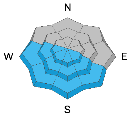
An isolated or MODERATE danger exists on all other aspects and elevations where human triggered avalanches involving slabs of wind drifted snow are possible.
As the day heats up we'll see a MODERATE danger for loose wet avalanches on sun exposed slopes.

Low
Moderate
Considerable
High
Extreme
Learn how to read the forecast here
Special Announcements
Geyser Pass Road: The road was plowed Thursday but unfortunately new snow and especially the wind filled it back in. Reports yesterday were of very sporty driving conditions. 4wd and possibly even chains will be required.
Grooming: Groomers will be up and at it today!
Weather and Snow
6:00 a.m. Snow and Weather Data
24 Hour Snow 3" 72 Hour Snow 18" Season Total Snow 219" Base Depth at Gold Basin 83"
Winds on Pre Laurel Peak SE 25-30 G40 Temp 19F
Weather
Today will be our only break from stormy weather before a closed low off the Pacific coast moves eastward into the 4 Corners on Sunday. Look for mostly sunny skies, continued breezy SW winds blowing in the 20-25 mph range, with high temps finally warming up to near normal in the low 30's. Sunday will be cloudy and snowy as the low pressure system moves quickly through with another 3"-5" possible. Unsettled weather continues next week.
General Conditions
24-36 hour storm totals have been a little hard to decipher with all the blowing and drifting going on. Observers yesterday afternoon cleared 12" off the storm board but the nearby SNOTEL is reporting about 8" since Thursday night. All said, we've picked up close to 2' of snow this week but you may be hard pressed to find it with all the wind we've had. Deep drifts have formed on leeward, northerly aspects while windward facing slopes have been scoured and sculpted. Unstable areas of wind drifted snow remain the primary concern, and steep wind loaded slopes should be avoided. With a strong sun and rapidly warming temps today, we may also see some loose, wet avalanches on sun exposed slopes that have fresh snow on them.
My partners and I were up on Thursday. This video gives a clear idea what the wind has been doing.
Snowpack and Weather Data
Gold Basin Storm Stake (10,000')
Gold Basin SNOTEL site (10,000')
Wind Station on Pre-Laurel Peak (11,400')
Recent Avalanches
No new avalanches have been reported. See the La Sal Avalanche database here.
Avalanche Problem #1
Wind Drifted Snow
Type

Location

Likelihood

Size

Description
2' of snow this week and strong southerly winds have created thick slabs of wind drifted snow, primarily on slopes facing NW-N-E-SE. On steep, northerly aspects near and above treeline, human triggered avalanches 2'-3' deep are likely. Winds have mostly blasted S-W facing slopes, but isolated drifts may exist on the leeward sides of terrain features such as sub ridges, gully walls, and rock outcrops. Wind drifts are often recognizable by their smooth, rounded appearance, and cracking is a sign of instability. Avoid wind drifted slopes steeper than 30 degrees.
Avalanche Problem #2
Persistent Weak Layer
Type

Location

Likelihood

Size

Description
On some northerly aspects, wind drifted snow is sitting on top of a layer of weak faceted snow that formed on the surface earlier this month. It isn't widespread, and it hasn't proven to be very reactive in stability tests, but we haven't had any visibility to see if it reacted to this last storm cycle. I hope to get a better handle on it today. Regardless, travel advice remains the same as all steep, northerlry aspects should be avoided.
Avalanche Problem #3
Wet Snow
Type

Location

Likelihood

Size

Description
As the first blast of sun and warm temperatures hits the recent snow, we may some we loose aciivity on steep, sun exposed slopes as the day heats up. Look for signs of instability such as rollerballs and pinwheels, and move off of and out from under steep terrain when these signs are present.
Additional Information
Are you wondering how cell phones and other electronic devices can interfere with your avalanche transceiver? The "20/50 Rule" is that you want your beacon 20cm (8") away from other electronics while transmitting and 50cm (20") away from electronics while searching. Get the full scoop here.
General Announcements
This forecast is from the U.S.D.A. Forest Service, which is solely responsible for its content. This forecast describes general avalanche conditions and local variations always occur. This forecast will be updated by 7:30 tomorrow morning.