Sign Up for the Utah Snow and Avalanche Workshop (USAW) on December 7th!

Forecast for the Moab Area Mountains

Dave Garcia
Issued by Dave Garcia on
Wednesday morning, February 15, 2023
Areas of MODERATE danger exist above treeline on all aspects for soft slabs of wind drifted snow, and human triggered avalanches are POSSIBLE. You will find a LOW avalanche danger out of the wind zone near treeline and below.
The new snow is poorly bonded to the old hard snow surface. Loose dry snow avalanches can be triggered by skiers and riders in very steep terrain today.
Low
Moderate
Considerable
High
Extreme
Learn how to read the forecast here
Special Announcements
Are you wondering how cell phones and other electronic devices can interfere with your avalanche transceiver? The "20/50 Rule" is that you want your beacon 20cm (8") away from other electronics while transmitting and 50cm (20") away from electronics while searching. Get the full scoop here.
Geyser Pass Road: The road is not plowed and there is about 10 inches of snow on the upper half. Four wheel drive and good tires recommended. If road crews have time, they might plow the Geyser Pass road today. If they get to it, the gate will close around noon for plowing.
Grooming: Matt is going up to groom trails today.
Weather and Snow
6:00 a.m. Snow and Weather Data
24 Hour Snow 7" 72 Hour Snow 11" Season Total Snow 197" Base Depth at Gold Basin 75"
Winds on Pre Laurel Peak SE 24 G 32 Temp 8 F
Weather
It's a cold morning in Gold Basin at 8 degrees F. Temperatures will stay in the single digits today. The wind should back off slightly and shift to the NE at 10-15 mph. We should see light snow showers and maybe another 1-2" out of this storm. Thursday is another cold day with single digit temperatures. Friday brings a warm up and sunny skies that will last into the weekend. The next chance for snow is Monday night into Tuesday.

General Conditions
Skiing and riding conditions are greatly improved by 11 inches of new snow. Prior to the storm, hard and slick surfaces existed around the compass. The new snow is very low density, and you will still feel the hard crusts underneath. The best skiing in is low elevation terrain and sheltered areas that had the least amount of wind damage before the storm. Backcountry travelers need to be aware of freshly formed slabs of wind drifted snow on all aspects above treeline. These drifts will be most sensitive on Northerly facing slopes that harbor weak, faceted snow that formed in the top of the snowpack before the storm. For more information on this, check out my field work from yesterday. Chris Benson also found some faceted snow in his travels on Sunday.

Snowpack and Weather Data
Gold Basin Storm Stake (10,000')
Gold Basin SNOTEL site (10,000')
SNOTEL site near Geyser Pass Winter Trailhead (9600')
Wind Station on Pre-Laurel Peak (11,400')
NWS forecast for the La Sal Mountains.
Recent Avalanches
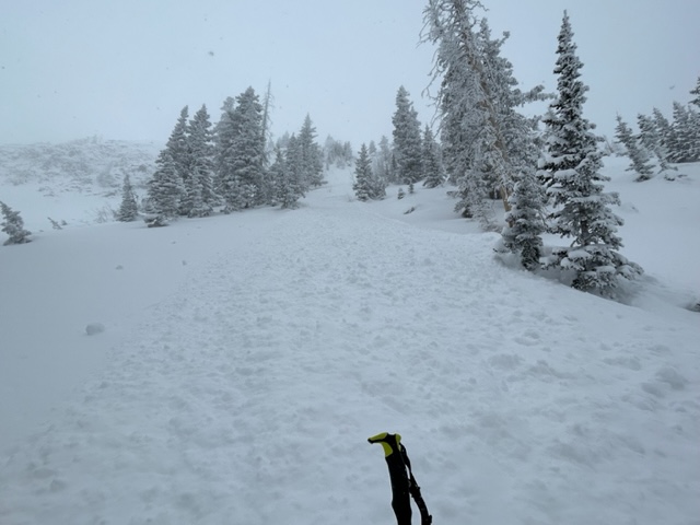
Yesterday I observed a handful of dry loose avalanches that ran naturally in steep terrain. The new snow is poorly bonded to the hard, old snow surface, and skier triggered sluffs are possible in steep terrain today.
This dry loose avalanche ran naturally in the steep chutes above Tele Gold.
See the La Sal Avalanche database here.
Ad
Avalanche Problem #1
Wind Drifted Snow
Type
Location
Likelihood
Size
Description
Fresh, soft slabs of wind drfited snow can be found on all aspects above treeline today. These drifts will be most pronounced on the north side of the compass. Terrain features can cause mountain winds to swirl and change direction, and load a variety of aspects. You are likely to find fresh wind drifts on the lee side of exposed ridges and in and around terrain features. Watch for and avoid drifts on gully walls, under cliff bands, along sub-ridges, in scoops, saddles, and sinks.
I am especially concerned about Northerly facing slopes that harbor weak facets near the top of the pack. I expect any wind drifts to be sensitive and easily triggered on these slopes.
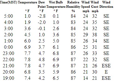
Southeast winds were really cranking on Pre-Laurel last night. The photo below shows winds from 7 PM on.
Avalanche Problem #2
New Snow
Type
Location
Likelihood
Size
Description
Rider triggered loose dry snow avalanches are possible in steep terrain today. The snow surface prior to the storm was very hard and slick. The new snow came in cold and light, and is poorly bonded to the old snow surface. I expect the storm snow to be loose and unconsolidated again today. Anticipate rider triggered sluffs if you find yourself in very steep terrain today. Even a small sluff can have significant consequences if a person is in a precarious position or if a terrain trap exists below.
Additional Information
General Announcements
This forecast is from the U.S.D.A. Forest Service, which is solely responsible for its content. This forecast describes general avalanche conditions and local variations always occur. This forecast will be updated by 7:30 tomorrow morning.