Check out our Holiday Auction - Sign Up for the Utah Snow and Avalanche Workshop (USAW)

Forecast for the Moab Area Mountains

Dave Garcia
Issued by Dave Garcia on
Tuesday morning, February 14, 2023
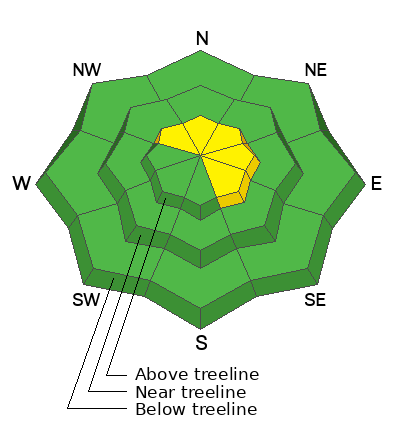
Areas of MODERATE danger exist above treeline on slopes that face NW-N-NE-E-SE. Sensitive soft slabs of wind drifted snow will continue to develop on these leeward slopes and human triggered avalanches are POSSIBLE. Get out of the wind zone and you will find a generally LOW danger.
Low
Moderate
Considerable
High
Extreme
Learn how to read the forecast here
Special Announcements
Are you wondering how cell phones and other electronic devices can interfere with your avalanche transceiver? The "20/50 Rule" is that you want your beacon 20cm (8") away from other electronics while transmitting and 50cm (20") away from electronics while searching. Get the full scoop here.
Geyser Pass Road: The road is plowed and widened with a snow packed surface.
Grooming: Trails were last groomed on Monday.
Weather and Snow
6:00 a.m. Snow and Weather Data
24 Hour Snow 4" 72 Hour Snow 4" Season Total Snow 190" Base Depth at Gold Basin 70"
Winds on Pre Laurel Peak W 13 Temp 18F

Weather
It's about ten degrees colder this morning than it was yesterday. Temperatures have maxed out for the day, and will slowly drop as the day goes on. Overnight lows will be subzero. Today winds will blow 15-20 mph out of the WSW. Snow showers will continue, piling up another 2-4 inches today, and maybe another 3-6" tonight accompanied by moderate WSW winds. Tomorrow will be downright cold, with continued light snow showers and a high temperature around zero degrees. North winds will blow around 20-25 mph. Skies clear Wednesday night and we can expect cold, sunny weather into the weekend, with the next chance for snow Sunday into Monday.

General Conditions
The mountains picked up four inches of new snow from yesterday's quick moving system. Prior to the storm, conditions were getting pretty rough out there, and the small amount of new snow will help. With only four inches you will still feel the bottom, with hard sun crusts on Southerlies, and firm wind board and sastrugi elsewhere. Backcountry travelers will need to be aware of changing conditions in the mountains. It has been green light conditions for big objectives in the alpine. It's time to dial it back a bit, and be on the lookout for freshly formed slabs of wind drifted snow on leeward slopes above treeline. Fresh drifts will continue to form today as we pick up more snow accompanied by moderate winds out of the WSW.
Chris Benson was out and about in the South Mountain region Sunday and he observed weakening surface snow in some areas with intermittent winds slabs on top. Although not a widespread problem at this time, as weak surface snow and older slabs get covered up, the danger for deeper avalanches will likely increase.

Snowpack and Weather Data
Gold Basin Storm Stake (10,000')
Gold Basin SNOTEL site (10,000')
SNOTEL site near Geyser Pass Winter Trailhead (9600')
Wind Station on Pre-Laurel Peak (11,400')
NWS forecast for the La Sal Mountains.
Recent Avalanches
No new avalanches were reported in the backcountry. See the La Sal Avalanche database here.
Ad
Avalanche Problem #1
Wind Drifted Snow
Type
Location
Likelihood
Size
Description
Westerly winds bumped up after midnight and began to blow and drift the four inches of new snow into shallow soft slabs. Sensitive slabs of wind drifted snow are most pronounced on leeward slopes above treeline. These slabs will continue to develop as more snow piles up today and the wind continues to blow. Fresh drifts will appear smooth, round, and fat. Cracking in the snow surface is a sure sign you have encountered a fresh drift.
We have been in a period of low danger for quite some time, and conditions are changing in the mountains. It is time to put our avalanche eyeballs on again, and be on the lookout for signs of instability. I am personally dialing back my terrain choices for the next few days. Even a small avalanche triggered in a shallow wind drift can quickly get out of hand in extreme terrain.
Additional Information
With a likely rise in danger over the next few days, take the time to refresh what each level of the North American Public Avalanche Danger Scale means.
General Announcements
This forecast is from the U.S.D.A. Forest Service, which is solely responsible for its content. This forecast describes general avalanche conditions and local variations always occur. This forecast will be updated by 7:30 tomorrow morning.