Forecast for the Moab Area Mountains

Dave Garcia
Issued by Dave Garcia on
Wednesday morning, February 12, 2025
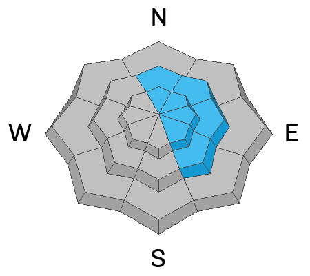
The overall danger is LOW, and human-triggered avalanches are unlikely. With two inches of snow overnight and elevated winds out of the west, it may be possible to trigger shallow soft slab avalanches of wind-drifted snow on the lee side of ridge lines near the treeline and above.
Low
Moderate
Considerable
High
Extreme
Learn how to read the forecast here
Special Announcements
We are deeply saddened to report an avalanche fatality in East Bowl of Silverfork in the Salt Lake Area Mountains on Saturday. We will provide a full accident report in the coming days.
Check out the latest edition of the UAC podcast with Moab forecaster Dave Garcia where he talks about the challenges of forecasting for our remote and isolated range with limited information.
Geyser Pass Road: Surface is mainly snowpacked and icy above and bare dirt down low. AWD with good tires recommended.
Grooming Conditions: Eric groomed all trails on Sunday.
Weather and Snow
6 A.M. Snow and Weather Data
24 Hour Snow: 2" 72 Hour Snow: 2" Season Total Snow: 65" Depth at Gold Basin: 28"
Winds on Pre-Laurel Peak: WNW 10-20 G 24 Temp: -5° F Percent of Normal (SWE): 73%
Weather
Gold Basin is very cold at -5° F this morning. Westerly winds are blowing 10-20 MPH with slightly higher gusts. Moderate to strong westerlies will continue throughout the day. Look for clearing skies, mostly sunny conditions, and a high temperature around 10° F. On Thursday, deep atmospheric river moisture moves over the California coast and the western Great Basin. Skies will become increasingly cloudy and southwest winds may gust up to 40 MPH. Snowfall will begin Thursday night. This appears to be our first significant snowfall in a long time, stay tuned for details.
General Conditions
The big news is that we have finally broken our dry spell with 1 to 2 inches of new snow across the range. Skiing and riding conditions will still be rough. This is the first snow in over a month, and warm temperatures, sunshine, and recent sustained strong winds have seriously beaten down the snow surface. Regardless, it is nice to see some snow in the air. Two inches of new snow will not increase the avalanche danger, but shallow drifts may have formed on the lee side of ridge lines near treeline and above. If you are out today look for signs of wind-drifted snow.
Snowpack and Weather Data
Gold Basin SNOTEL site (10,000')
SNOTEL site near Geyser Pass Winter Trailhead (9600')
Wind Station on Pre-Laurel Peak (11,400')
NWS forecast for the La Sal Mountains.
Recent Avalanches
Ad
Avalanche Problem #1
Wind Drifted Snow
Type
Location
Likelihood
Size
Description
Your primary avalanche concern is shallow, soft slabs of wind-drifted snow. Look for sensitive drifts on the lee side of ridge lines near treeline and above. The long dry spell left behind many hard and slick surfaces, and drifted snow will not bond well. With only two inches of new snow, I really don't expect these shallow drifts to pose much of a threat, and the overall danger remains LOW.
Additional Information
Sign up for text alerts to get the most up to date information about changing conditions, road plowing, special avalanche announcements.
Follow us on Instagram @utavy_moab
General Announcements
This forecast is from the U.S.D.A. Forest Service, which is solely responsible for its content. This forecast describes general avalanche conditions and local variations always occur.