Forecast for the Moab Area Mountains

Issued by Eric Trenbeath on
Monday morning, December 9, 2024
Monday morning, December 9, 2024
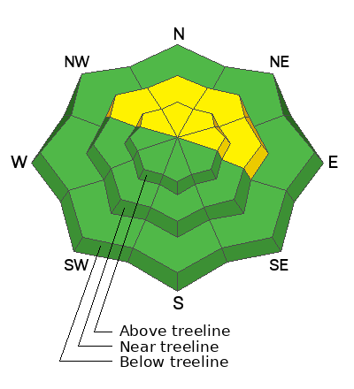
A MODERATE avalanche danger exists on steep slopes near and above treeline that face NW-N-E and human-triggered avalanches failing on a persistent weak layer remain POSSIBLE.
The avalanche danger is mostly LOW on all other aspects. Small avalanches on isolated terrain features are possible.
Conditions remain thin and rocks, stumps, and dead fall still pose a significant hazard.

Low
Moderate
Considerable
High
Extreme
Learn how to read the forecast here
 Special Announcements
Saturday, December 14 - 3rd Annual UAC Moab/LUNA Winter Kickoff Party, 6 PM at the MARC. Information and tickets available here.
Six spots remain for Moab and San Juan County locals for our Backcountry 101 class on Jan 31-Feb 1. Click here to sign up and use the discount code MOAB2025.
Geyser Pass Road: The La Sal Loop Road will be closed above Pack Creek Monday-Friday from 8:30 to 5:30 for construction through December 18. Access to the Geyser Pass Winter Trailhead will be from Castle Valley or Sand Flats Road during these hours. Click here for more information.
 Weather and Snow
6 A.M. Snow and Weather Data
24 Hour Snow: 0" 72 Hour Snow: 0" Season Total Snow: 44" Depth at Gold Basin: 24"
Winds on Pre-Laurel Peak: WNW 10-15 mph Temp: 20° F Percent of Normal (SWE): 177%
Weather
A cold front on the leading edge of a broad, upper level trough will move through the region today. We'll see cloudy skies, blustery NW winds, and a chance for scattered snow showers this morning. Things should start to clear off by afternoon. It'll be cold up there today with high temps of around 20°. Dry and sunny conditions on Tuesday.
General Conditions
I'm afraid today's NW winds may put a damper on the loose, dry, surface snow we've been enjoying. At the very least, I expect it will take care of much of the surface hoar that's been growing out there. I must say, my enthusiasm for how good it's been "all things considered" is waning. It's thin, getting bare on southerly aspects, and the surface continues to weaken. Sunny skies and soft supportable conditions have been fun, but we need snow.
Snowpack and Weather Data
Gold Basin SNOTEL site (10,000')
Wind Station on Pre-Laurel Peak (11,400')
 Recent Avalanches
It's been nearly two weeks since the last avalanche cycle, but Chris Benson got around to Beaver Basin yesterday to have a closer look at a slide he reported earlier. It's quite impressive and worth a look.
Avalanche Problem #1
Persistent Weak Layer
Type
Location

Likelihood
Size
Description
Poor snowpack structure remains with a dense, cohesive slab over top of weak, faceted snow, but time and warm daytime temperatures have helped to stabilize the snowpack. Areas where you could still trigger an avalanche are on steep slopes near and above treeline that face NW-N-E. If you decide to step out into this kind of terrain, choose planar slopes without complex terrain features. Avoid likely trigger points such as steep convexities, or shallow points along slope margins or near rock outcrops.
Additional Information
Sign up for text alerts to get the most up to date information about changing conditions, road plowing, special avalanche announcements.
Follow us on Instagram @utavy_moab
General Announcements
This forecast is from the U.S.D.A. Forest Service, which is solely responsible for its content. This forecast describes general avalanche conditions and local variations always occur.


