AVALANCHE WARNING!! Tap for info
UDOT PLANNED AVALANCHE CLOSURES!!

Forecast for the Moab Area Mountains

Eric Trenbeath
Issued by Eric Trenbeath on
Saturday morning, December 28, 2024
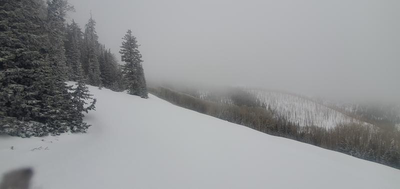
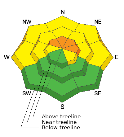
The avalanche danger is CONSIDERABLE on steep, wind drifted slopes above treeline that face NW-N-NE-E and human triggered avalanches are likely. Avalanches involving slabs of wind drifted snow can step down into deeper, persistent weak layers causing deeper, more dangerous avalanches.
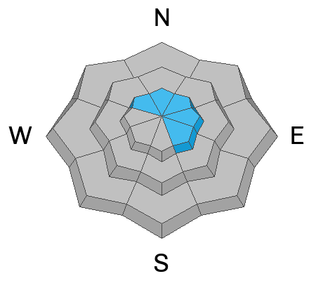
A MODERATE danger exists near treeline and below on steep slopes facing W through N through E. Human triggered avalanches failing on persistent weak layers of sugary, faceted snow are possible.
It's still low tide out there, and the new snow will just barely cover rocks, stumps, and logs beneath the surface.
Low
Moderate
Considerable
High
Extreme
Learn how to read the forecast here
Special Announcements
Geyser Pass Road: Expect slick conditions with a couple inches of new snow over a hard, icy surface. AWD with good tires required.
Grooming Conditions: Gavin ran his snowcat into Gold Basin and over Geyser Pass so trails are smooth!
Now is a great time to dial in your safety gear including putting fresh new batteries in your beacons! Local shops across the state will be handing out free Batteries for Beacons now until February 1, 2025. All you need to do is fill out a quick survey and grab the AAA or AA batteries you need to keep your beacon fresh this season. Head into Moab Gear Trader to get yours!
Weather and Snow
6 A.M. Snow and Weather Data
24 Hour Snow: 3" 72 Hour Snow: 7" Season Total Snow: 52" Depth at Gold Basin: 29"
Winds on Pre-Laurel Peak: WNW 5-8 Temp: 17° F Percent of Normal (SWE): 113%
Weather
WNW winds backed off into the single digits around midnight signaling the end of the stormy period. Today, look for partly sunny skies, light westerly winds, and high temps in the upper 20's. Sunday will be mostly sunny. Another system passes by to the north Sunday night into Monday, followed by a ridge of high pressure.
General Conditions
With a cumulative 6-10 inches of new snow since Christmas, conditions would be greatly improved if only we had a little more base. Jason Ramsdel reported great turning and riding in the top half of the North Woods, with downed trees barely covered on the lower. The snowpack beneath the recent snow is mostly faceted through to the ground. Above treeline, strong SW through NW winds over the past three days have blown and drifted snow on to leeward slopes while alternately scouring exposed, windward areas. South facing terrain has very thin, to no snowcover.
Snowpack and Weather Data
Gold Basin SNOTEL site (10,000')
SNOTEL site near Geyser Pass Winter Trailhead (9600')
Wind Station on Pre-Laurel Peak (11,400')
NWS forecast for the La Sal Mountains.
Nice to see it looking wintery up there. Jason Ramsdell photo.
Recent Avalanches
Ad
Avalanche Problem #1
Wind Drifted Snow
Type
Location
Likelihood
Size
Description
An accumulated 6-10 inches of snow and strong westerly winds over the past few days have created unstable slabs of wind drifted snow above treeline on slopes facing NW through SE. Look for recent deposits of wind drifted snow on the leeward sides of ridge crests and terrain features in upper elevation, wind affected terrain. Slabs will be poorly bonded to either slick hard surfaces, or the weak, faceted, old snow surface and human triggered avalanches up to a foot deep are likely. Recent drifts are often recognizable by their smooth, rounded appearance, and cracking is a sign of instability. A triggered wind slab has the potential to step down into weaker faceted layers causing a deeper and more dangerous avalanche.
Avalanche Problem #2
Persistent Weak Layer
Type
Location
Likelihood
Size
Description
Incremental loading over the past few days has been adding stress to our weak, faceted snowpack increasing the odds for human triggered avalanches. Above treeline, areas of wind drifted snow have added additional stress to persistent weak layers, and human triggered avalanches are likely on slopes facing NW through E. Near treeline and below, the underlying snowpack is very weak on all slopes facing W through E, but we may not yet have a developed slab on top. Human triggered avalanches are possible in these areas, particularly on slopes where wind thickened slabs exist. Choose terrain wisely. Dig down in the snow and see if you can detect a denser slab on top of weaker snow. Cracking and collapsing are signs of instability. It's time to put the persistent weak layer problem back on our radar.
Additional Information
Sign up for text alerts to get the most up to date information about changing conditions, road plowing, special avalanche announcements.
Follow us on Instagram @utavy_moab
General Announcements
This forecast is from the U.S.D.A. Forest Service, which is solely responsible for its content. This forecast describes general avalanche conditions and local variations always occur.