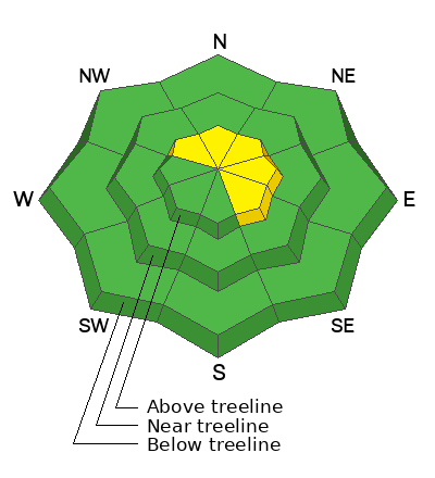
Geyser Pass Road: The road is plowed to the trailhead. Surface is dirt down low, with hard slick patches of snow above. AWD with good tires is recommended.
Grooming Conditions: Surfaces that were packed solid from weeks of ski and snowmobile traffic now have a couple of inches on them.
Now is a great time to dial in your safety gear including putting fresh new batteries in your beacons! Local shops across the state will be handing out free Batteries for Beacons now until February 1, 2025. All you need to do is fill out a quick survey and grab the AAA or AA batteries you need to keep your beacon fresh this season. Head into
Moab Gear Trader to get yours!
6 A.M. Snow and Weather Data
24 Hour Snow: 1" 72 Hour Snow: 3" Season Total Snow: 49" Depth at Gold Basin: 26"
Winds on Pre-Laurel Peak: WNW 10-20 Temp: 17° F Percent of Normal (SWE): 107%
Weather
Winds from the WNW have been have been blowing pretty strong since mid-morning yesterday averaging 15-20 mph with occasional gusts in the 30's. They've backed off a bit this morning. The next shortwave trough moves through the region today again favoring areas to the north. We should see a few inches of snow this afternoon. Westerly winds will continue to blow in the 10-20 mph range along ridge tops, and high temps at 10,000' will be in the low to mid 20's. Things dry out for the weekend with another pulse of moisture moving in on Sunday night.
General Conditions
The Christmas Eve storm did improve conditions a bit, especially up high where Dave Garcia
reported finding 4" of new snow. Another
observation described things as an "East Coast powder day." Both reported a fair amount of snow being transported
(see video) and the existence of isolated slabs of wind drifted snow, primarily above treeline. Sheltered, northerly facing terrain is where you will find the most benefit from the recent snow. In these areas the snowpack has generally lost cohesion but at least it's soft. The problem is that it's still quite shallow, and no longer very supportive.
A note on persistent weak layers: Persistent weak layers in the snowpack are generally benign at this time but looking ahead, it's important that we keep the existing poor snowpack structure in mind. Generally speaking, the snowpack is faceted through to the ground and the surface snow is very weak. There are areas where the midpack still has some semblance of a denser slab, but with very weak snow above and below, it's turned into an unstable base for future snowloads. If significant snow starts to accumulate, these layers will again become reactive, and all steep, northerly facing terrain will need to be avoided.
Snowpack and Weather Data


