Forecast for the Moab Area Mountains

Eric Trenbeath
Issued by Eric Trenbeath on
Saturday morning, December 22, 2018
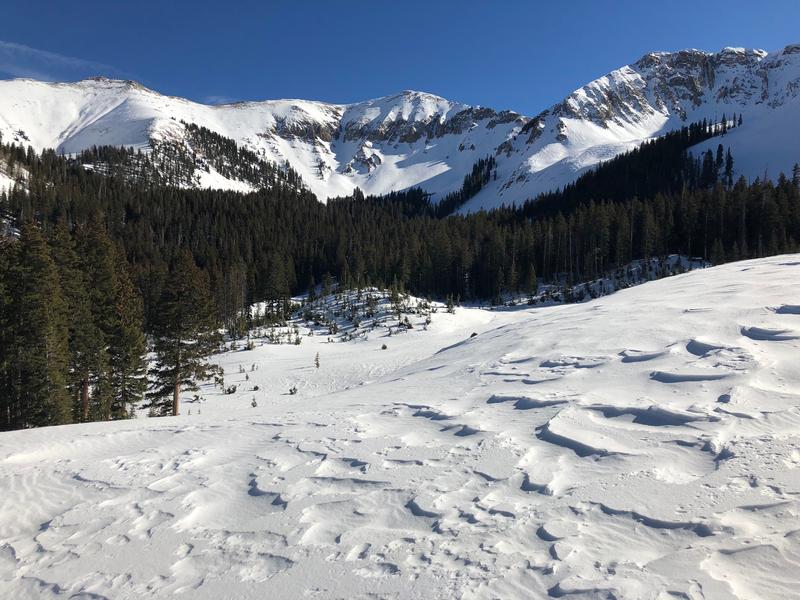
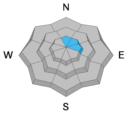
There remains an isolated, or MODERATE danger for human triggered avalanches breaking down into buried, persistent weak layers of sugary, faceted snow. Steep, rocky, upper elevation terrain that has a northerly aspect is the most suspect. On upper elevation slopes with a N-E aspect, there is a MODERATE danger for triggering a stiff slab of wind drifted snow. Suspect slopes with a smooth, rounded appearance or that sound hollow like a drum. Most other terrain has generally LOW danger.
Low
Moderate
Considerable
High
Extreme
Learn how to read the forecast here
Special Announcements
The new UAC IOS mobile app is now available on the app store. Check out the new "My Weather" feature.
Check out the new free online avalanche course series developed by the Utah Avalanche Center. This is a great way to refresh your skills or prepare you for a Backcountry 101 or Level 1 class.
Weather and Snow
Skies are clear, westerly winds are averaging 20 mph along ridge tops, and 10,000' temps are in the low 20's. Today we'll see mostly sunny skies with increasing NW winds. Daytime highs will be in the upper 20's. We should see clouds moving in late Sunday as a weak system moves through to the north, followed by a stronger system on Christmas.
Wind and sun have severely damaged exposed snow surfaces and you'll have to work hard to find soft snow in sheltered locations. Low snow conditions still prevail, and they are getting lower. Be wary of rocks and deadfall lurking just beneath the surface. Base depth in Gold Basin is 28".
For further information check out the most recent observations here.
New snow totals in Gold Basin (10,000')
Snow totals at the Geyser Pass Trailhead (9600')
Wind, temperature, and humidity on Pre Laurel Peak (11,700')
National Weather Service point forecast.
Current snow conditions are pretty rough but it's still beautiful up there!
Ad
Avalanche Problem #1
Persistent Weak Layer
Type
Location
Likelihood
Size
Description
Time and warm temperatures have helped to stabilize the snowpack, but persistent weak layers of loose, sugary, faceted snow remain. Though the likelihood of triggering an avalanche is low, if you manage to find the right trigger point in a rocky, shallow area, you could still trigger a dangerous avalanche 2'-4' deep. For myself, I'll continue to avoid steep, rocky terrain that has a northerly aspect.
Avalanche Problem #2
Wind Drifted Snow
Type
Location
Likelihood
Size
Description
Strong westerly winds over the last week have created stiff slabs of wind drifted snow on top of old in the upper elevations, primarily on slopes with an easterly component. Most of these are pretty welded into place by now but continue to cast a wary eye toward steep slopes, and areas such as cross-loaded gullies that have a smooth rounded appearance, or where the snow feels hollow underneath.
Additional Information
The road into Gold Basin was groomed on Thursday, and Dave and Kirstin groomed up and around Geyser Pass yesterday so we are looking good for the weekend. With the current snow conditions, Nordic skiing may the best game in town!
General Announcements
Your information can save lives. If you see anything we should know about, please help us out by submitting snow and avalanche observations HERE. You can also call me at 801-647-8896, or send me an email: eric@utahavalanchecenter.org.
Support the UAC through your daily shopping. When you shop at Smith's, or online at REI, Backcountry.com, Patagonia, NRS, Amazon, eBay by clicking on these links, they donate a portion of your purchase to the UAC. If you sell on eBay, you can have your See our Affiliate Page for more details on how you can support the UAC when you shop
This advisory is from the U.S.D.A. Forest Service, which is solely responsible for its content. This advisory describes general avalanche conditions and local variations always occur.