Forecast for the Moab Area Mountains

Eric Trenbeath
Issued by Eric Trenbeath on
Thursday morning, November 28, 2019
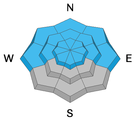
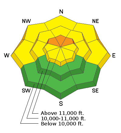
Expect a rising avalanche danger over the next two days! Blowing and drifting of the most recent snow has created a CONSIDERABLE avalanche danger in upper elevation, wind-exposed terrain primarily on slopes facing NW-N-NE You are most likely to encounter this problem on open scree slopes right around treeline and above that had about a foot or more of pre-existing snow. Mid and low elevation terrain has a MODERATE danger on steep slopes that have recent deposits of wind drifted snow. Most avalanche terrain remains difficult to access due to overall low snow coverage, but if you managed to trigger a pocket of wind drifted snow, a ride over rocks, sticks, or even the ground would be rough.
Low
Moderate
Considerable
High
Extreme
Learn how to read the forecast here
Special Announcements
Grand County plowed the road yesterday. Expect to find areas of drifted snow across the road today.
The First Annual Avalanche Awareness Week is December 2-7 We have a week full of fun and educational events planned. Check out the schedule here.
The annual free Know Before You Go avalanche awareness talk will be held at the Grand County Library on Thursday, Dec 5 at 6:00 p.m. Hope to see you there!
Weather and Snow
As you can see, winds yesterday were having their way with the new snow. Overnight they continued to blow from the SE in the 30's with gusts in the mid to high 40's. Expect the trend to continue through Friday.
A powerful storm is on our doorstep but it looks like most of the snow will be left on the threshold, as in the Abajo Mountains to our south where 2'-3' are expected. That's not to say we're not going to get a good shot of snow, 12" - 18" seems likely when it's all said and done. Today we'll see increasing southerly winds with gusts as high as 60 mph. High temps will be near 30F at 10,000'. 2"-4" of snow are possible. We should pick up a few more inches tonight before the main event kicks in tomorrow.
Tuesday's 25" has settled to about 16". Below about 10,000' the new snow fell on a "base" of 8" or less. Above 10,000' about a foot of snow existed with higher amounts possible. Coverage is still very thin, and the low-density snow has only thinly covered the rocks, sticks, and deadfall but we are definitely on our way. For now, however, better confine your riding and turning to roads and known grassy meadows.
Wind, temperature, humidity on Pre Laurel Peak (11,700')
Storm totals at Gold Basin Study Plot (10,000').
Snotel site near Geyser Pass Trailhead (9600').
NWS weather forecast.
Ad
Avalanche Problem #1
Wind Drifted Snow
Type
Location
Likelihood
Size
Description
Look for areas of blown and drifted snow in wind-exposed terrain on slopes facing W-N-E. The problem will be most acute on open, poorly anchored scree slopes right around treeline and above. Look for areas of wind drifted snow on the leeward sides of ridge crests and terrain features such ss gully walls and sub ridges. Most of this terrain will be difficult to access due to overall low snow coverage, but if you managed to trigger a pocket of wind drifted snow, a ride over rocks, sticks, or even the ground would be rough.