Forecast for the Moab Area Mountains

Eric Trenbeath
Issued by Eric Trenbeath on
Wednesday morning, November 27, 2019
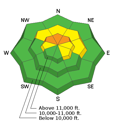
Expect a rising avalanche danger over the next several days! Blowing and drifting of the new snow has created a MODERATE avalanche danger in wind-exposed terrain primarily on slopes facing NW-N-E. You are most likely to encounter this problem on open scree slopes right around treeline and above that had about a foot or more of pre-existing snow. In the higher elevations, areas of CONSIDERABLE danger may exist. Look for areas of wind drifted snow on the leeward sides of ridge crests and terrain features such as gully walls and sub ridges. Most of this terrain will be difficult to access due to overall low snow coverage, but if you managed to trigger a pocket of wind drifted snow, a ride over rocks, sticks, or even the ground would be rough. With a powerful storm on tap for the holiday expect the danger to rise over the next several days!
Low
Moderate
Considerable
High
Extreme
Learn how to read the forecast here
Special Announcements
Grand County will be plowing today, expect the gate to be locked this morning while operations are underway.
The First Annual Avalanche Awareness Week is December 2-7 We have a week full of fun and educational events planned. Check out the schedule here.
The annual free Know Before You Go avalanche awareness talk will be held at the Grand County Library on Thursday, Dec 5 at 6:00 p.m. Hope to see you there!
Weather and Snow
Yesterday's overachieving storm delivered more than 2' of light, fluffy, powder to the mountains. Though not great base building material, the copious amounts of new snow were a welcome sight. Below about 10,000' the new snow fell on a "base" of 8" or less. Above 10,000' about a foot of snow existed with higher amounts possible. In short, coverage is still very thin, and the new low-density snow has only thinly covered the rocks, sticks, and deadfall.
SE winds have been on the increase overnight averaging 25-30 mph with gusts in the mid 40's. Expect them to increase throughout the day. Skies will be cloudy with high temps in the low to mid 20's but the wind chill will make things feel positively frigid.
Southwest flow aloft will strengthen today ahead of a powerful and slow-moving storm system. Light snow should begin tonight and continue tomorrow with the real action not occurring until tomorrow night. Right now it looks like we should see at least a foot of new snow.
Wind, temperature, humidity on Pre Laurel Peak (11,700')
Storm totals at Gold Basin Study Plot (10,000').
Snotel site near Geyser Pass Trailhead (9600').
Ad
Avalanche Problem #1
Wind Drifted Snow
Type
Location
Likelihood
Size
Description
Look for areas of blown and drifted snow in wind-exposed terrain primarily on slopes facing NW-N-SE. You are most likely to encounter this problem on open, poorly anchored scree slopes right around treeline and above. Look for areas of wind drifted snow on the leeward sides of ridge crests and terrain features such ss gully walls and sub ridges. Most of this terrain will be difficult to access due to overall low snow coverage, but if you managed to trigger a pocket of wind drifted snow, a ride over rocks, sticks, or even the ground would be rough.