Forecast for the Moab Area Mountains

Eric Trenbeath
Issued by Eric Trenbeath on
Thursday morning, January 23, 2020
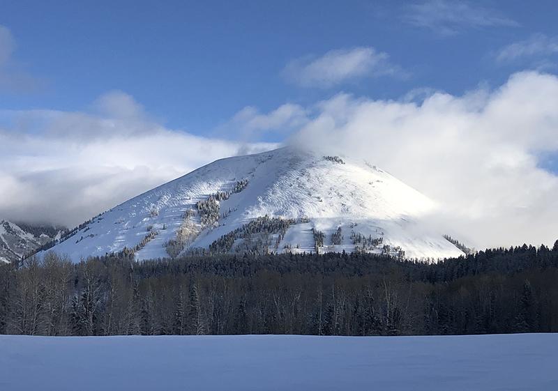
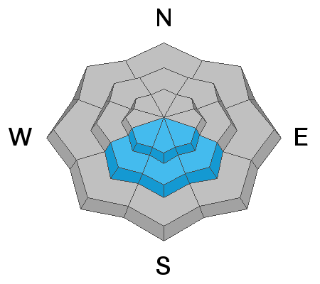
The avalanche danger is MODERATE today and human triggered avalanches involving a variety of problems are possible. Steep, wind drifted slopes right around tree line and above that face N-NE-E are the most likely areas for you to trigger an avalanche up to 18" deep. On upper elevation slopes, areas of wind drifted snow may be found on all aspects. Fresh drifts are recognizable by their smooth, rounded, or rippled appearance, and changes in snow depth along ridgelines can indicate areas of wind loading. Avoid steep, wind drifted slopes today.
There is also a MODERATE danger for triggering an avalanche on a buried persistent weak layer on steep SE-S-SW facing slopes. These usually safer slopes should be avoided until we better understand the extent of this problem.
And finally, though the likelihood has lessened, there remains a MODERATE danger for human triggered avalanches involving the most recent storm snow on steep slopes of all aspects.
Low
Moderate
Considerable
High
Extreme
Learn how to read the forecast here
Special Announcements
The final report on the avalanche fatality in Farmington Canyon is complete. You can read it here. Our deepest condolences go out to the friends, family, rescuers, and everyone affected by this tragic accident.
Our Backcountry 101 avalanche course has been scheduled for February 15, 16. The cost is $150. The course starts with a 4-hour classroom session the night of the 15th followed by a day in the field. It's a great way to increase your avalanche awareness and backcountry travel skills. Click here to register. A huge thanks to Moab Gear Trader for sponsoring this course. Please visit them for all your winter backcountry needs
Road Conditions: The road was plowed yesterday. Thank you Grand County!
Grooming update: Thanks to Matt from Rim Tours for grooming into Gold Basin and setting classic track. He rolled and packed the new snow up and over Geyser.
Weather and Snow
24 Hour Snow 0" Weekly Snow 10" Base Depth in Gold Basin 48" Wind NW 15-20 mph Temp 20F
The mountains picked up 8"-12" of medium density snow from Wednesday's storm. Yesterday, clouds covered the peaks for most of the day, and NW winds averaged 15-20 mph along ridge tops. Winds bumped up into the 20-25 mph for a few hours last night with gusts into the low 30's.
Today we should see mostly sunny skies in the mountains while the valley wallows under a thick deck of stratus clouds. Westerly winds will shift to more southerly averaging 15-20 mph along ridge tops. High temps will be in the mid to upper 20's. Conditions will be dry through the weekend. Long-range models are advertising a return to a more active pattern next week.
Conditions are greatly improved and I would rate the turning and riding as 3 star. You can still feel the bottom in some areas, and winds have affected some of the more exposed surfaces, particularly at upper elevations. Bottomless conditions can be found in sheltered locations.
A brief break in the clouds yesterday gave us a nice view of Haystack Mountain in the morning light. Note the wind affected snow surface including ripples that indicate fresh drifting.
Wind, temperature, humidity on Pre Laurel Peak (11,700')
Storm totals at Gold Basin Study Plot (10,000').
Snotel site near Geyser Pass Trailhead (9600').
NWS weather forecast
Recent Avalanches
In our travels yesterday, we observed a recent avalanche from a distance under the cliffs in Tele Gold. We'll be going in for a closer look today.
Ad
Avalanche Problem #1
Wind Drifted Snow
Type
Location
Likelihood
Size
Description
Winds have been pretty well behaved, especially by La Sal standards, but they have blown just enough to create fresh drifts up to 18" deep. These drifts were not particularly sensitive yesterday, but they certainly had a hollow feel to them in many areas. Their lack of sensitivity may lure you further downslope before they release, putting you in a much more dangerous situation. Most drifting has occurred right around treeline and above on slopes facing N-NE-E, but upper elevations have areas of drifted snow on all aspects. Fresh drifts are recognizable by their smooth, rounded, or rippled appearance, and changes in snow depth along ridgelines can indicate areas of wind loading. Avoid steep, wind drifted slopes today.
Avalanche Problem #2
Persistent Weak Layer
Type
Location
Likelihood
Size
Description
In our travels yesterday we observed the first collapses in the snowpack that we have felt in a long time and they occurred on SE and S facing slopes around 11, 500'. Problematic persistent weak layers are uncommon on southerly aspects, but not unheard of. I first observed the layer of weak facets under a crust on Saturday, but the recent load of new snow is what caused it to become reactive. We're going to need to gather more information on the extent of this problem but for now, I would consider steep slopes that face SW-S-SE to be dangerous. Collapsing and whumphing are obvious signs of instability.
Avalanche Problem #3
New Snow
Type
Location
Likelihood
Size
Description
The new snow has formed a dense cohesive slab. We did not find it to be particularly reactive yesterday, and cracking is isolated to right around your skis. In some locations, however, we found that it was not bonding well to the underlying, loose, old snow surface. I'm inclined to give the new snow another day to settle before I write off the potential for it to slide.
General Announcements
My radio interview on KZMU about the history of backcountry skiing in the La Sals, avalanche accidents, and unique snowpack has been saved in perpetuity. You can listen to it here.
Check out the avalanche beacon training park at the Geyser Pass Trailhead and practice your rescue skills!
This forecast is from the U.S. Forest Service, which is solely responsible for its content. This forecast describes general avalanche conditions and local variations always occur.