Forecast for the Logan Area Mountains

Toby Weed
Issued by Toby Weed on
Tuesday morning, February 18, 2025
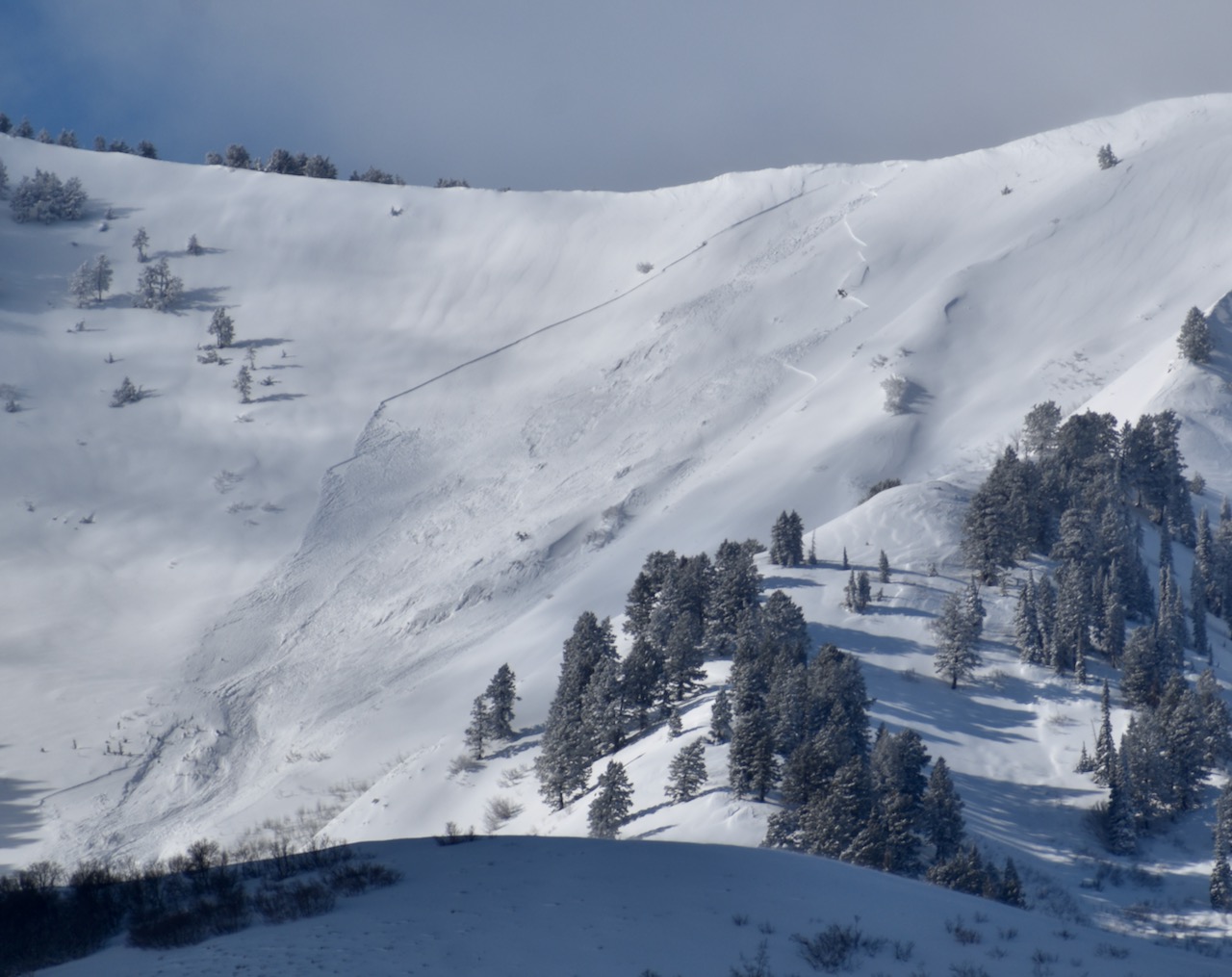
Dangerous avalanche conditions exist on backcountry slopes steeper than 30°. There is CONSIDERABLE danger in all upper and mid-elevation terrain, and people are likely to trigger dangerous avalanches of storm snow or wind drifted snow up to 3 feet deep. The danger is HIGH on drifted upper-elevation slopes facing northwest through southeast, where large natural avalanches are likely.
  • Careful snowpack evaluation, cautious route-finding, and conservative decision-making are essential for safe backcountry travel today.
  • Avoid travel in drifted upper elevation terrain, and stay clear of avalanche runouts.
Low
Moderate
Considerable
High
Extreme
Learn how to read the forecast here
Weather and Snow
The Logan area mountains picked up close to 3 inches of SWE (snow water equivalent) in the past 48 hours, with 6.2 inches since the morning of 2/13. Strong and sustained winds from the southwest and west created deep drifts and wind slabs in upper and mid-elevation terrain. Most recent local avalanches failed on weak layers within the new snow or on a weak layer capping a dirty crust from early February, but there are also other persistent weak layers buried deeper in the snowpack. It's impossible to know which weak layer will fail when stressed enough, but given the quantity of new snow, it really doesn't matter. With significantly less recent accumulations, heightened conditions exist in low elevation terrain, where human-triggered and wet avalanches of storm snow are possible.
The avalanche danger is complex; safe terrain choices are your best bet today, so the best strategy is to stay on slopes less than 30 degrees and out from under steeper terrain. You'll find excellent deep powder riding conditions in the meadows and low-angle terrain.

-The Tony Grove Snotel at 8400 feet reports 8 inches of new snow with 1.3 inches of SWE in the last 24 hours and 2.9 inches of SWE in the past 48 hours. It's 21° F, with 102 inches of total snow. The Card Canyon weather station at 8800 feet reports around 4 inches of new snow. It's 17° F, with 69 inches of total snow.
Winds on Logan Peak are blowing 23-37 mph from the northwest and it's 14° F. At 9500 feet on Paris Peak it's also 14° F, with winds blowing 10 to 16 mph from the west-southwest.

The National Weather Service has continued a Winter Weather Advisory through noon today. Expect heavy snowfall at times, with 3 to 7 inches of accumulation possible. High temperatures at 8500' will top out around 24° F. Gusty winds blowing from the west 13 to 18 mph, with gusts in the 30s are expected. Expect mostly cloudy skies tonight, with low temperatures around 15° F and winds from the west-northwest decreasing to 6 to 11 mph. Tomorrow will be mostly cloudy with a 50% chance of snow in the afternoon and 1 to 2 inches of accumulation possible. Expect a high temperature around 28° F, and winds from the southwest 7 to 11 mph. 3 to 7 inches of accumulation is possible Wednesday night, and unsettled wintery weather will continue through the work week.

Thank you for reading our forecasts before heading out into the backcountry - we've had four avalanche fatalities this season and do not want anyone else to die in an avalanche.

For more information, visit the UAC weather page here: Weather - Utah Avalanche Center
For Logan-specific weather, go here: Logan Mountain Weather - Utah Avalanche Center
Recent Avalanches
Over the weekend, we received many reports of natural and human-triggered small to medium-sized soft slab avalanches. We observed numerous large natural avalanches in the Wellsvilles, which occurred overnight Thursday through early Saturday morning. Some of these were well connected and ran over 2500', hitting Maple Bench above Mendon.
Read about all avalanches and observations in the Logan Zone HERE.
***Remember, the information you share about avalanches you see or trigger in the backcountry could save lives.
Ad
Avalanche Problem #1
Wind Drifted Snow
Type
Location
Likelihood
Size
Description
People are likely to trigger dangerous wind slab avalanches, consisting of drifted storm snow, in wind exposed terrain on many upper and mid-elevation slopes. Natural cornice falls and large wind slab avalanches are also likely as a tremendous amount of fresh snow has drifted into avalanche starting zones.
  • Wind slabs are stiffer than surrounding snow, and they are smooth, rounded and chalky looking, and can sound hollow, like a drum when you move around on them.
  • Wind slabs will be found on the lee side of major ridges and corniced slopes facing northwest through southeast, with the majority facing the east half of the compass.
  • Drifts and stiff slabs of wind-drifted snow also exist on all aspects in and around terrain features like sub-ridges, gullies, scoops, and cliff bands.
  • Cracking and whumpfs are sure signs of instability.
Avalanche Problem #2
New Snow
Type
Location
Likelihood
Size
Description
Soft slab and loose avalanches of storm snow are likely on steep slopes in upper and mid-elevation terrain. People are likely to trigger avalanches on slopes steeper than about 30°, and avalanches could be triggered remotely (from a distance) or from below steep slopes. Copious amounts of new snow blanket the range and, having accumulated on top of multiple weak layers, it's hard to know which slopes are the most tenuous. Recent sizable avalanches failed on weak layers within the new snow, and observers report finding weak new snow layers in their test pits.
Fishers need to be aware that wet avalanches of rain-saturated storm snow are possible in lower-elevation terrain, like the steep slopes above the Logan River.
Avalanche Problem #3
Persistent Weak Layer
Type
Location
Likelihood
Size
Description
Large and dangerous avalanches stepping down into older snow on one of several buried persistent weak layers are possible, especially in areas with shallower snow and poor snow structure. One suspect layer is found right on top of a dirty melt-freeze crust from the warm spell at the beginning of February. We've been monitoring other, more deeply buried PWLs, which may produce large avalanches, especially in outlying terrain. with shallow and generally weak snow.
  • Audible collapses (whumpfs) and shooting cracks are sure signs of instability, but these may not be present when avalanches occur.
  • Avalanches failing on a buried persistent weak layer might be triggered remotely (from a distance) or from below steep slopes.
Additional Information
On Saturday, I could see evidence of numerous natural avalanches in the Wellsville Range. This one in North Shumway is on an east-southeast facing slope.
General Announcements
-National Forest Winter Recreation Travel Maps show where it's open to ride: UWCNF Logan, Ogden LRD Tony Grove, Franklin Basin CTNF Montpelier
-For all questions on forecasts, education, Know Before You Go, events, online purchases, or fundraising, call 801-365-5522.
-Remember the information you provide could save lives, especially if you see or trigger an avalanche. To report an avalanche or submit an observation from the backcountry, go HERE.
-Receive forecast region-specific text message alerts to receive messages about changing avalanche conditions, watches, and warnings. Sign up and update your preferences HERE.

This forecast is from the U.S.D.A. Forest Service, which is solely responsible for its content. This forecast describes general avalanche conditions, and local variations always occur.