Check out our Holiday Auction

Forecast for the Logan Area Mountains

Mark Staples
Issued by Mark Staples on
Sunday morning, December 26, 2021
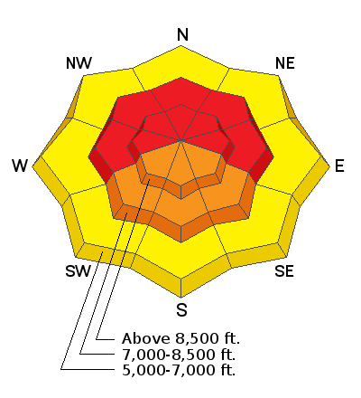
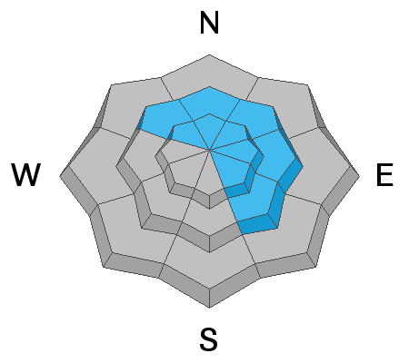
CONDITIONS ARE VERY DANGEROUS and conditions are ripe for an avalanche accident. Today both natural and human-triggered avalanches are very likely at mid and upper elevations facing East, West, and North where the avalanche danger is HIGH. All other slopes at mid and upper elevations have a CONSIDERABLE danger. At low elevations, avalanches will be possible and the danger is MODERATE.

Heads up - Because the new snow is generally dense and supportable, it won't seem like as much has fallen. The key point is that A LOT weight has been added to the snowpack which is adding a lot of stress to buried weak layers. Give yourself a wide safety margin today and avoid avalanche terrain.
Low
Moderate
Considerable
High
Extreme
Learn how to read the forecast here
Avalanche Warning
THE AVALANCHE DANGER IS HIGH WITH DANGEROUS AVALANCHE CONDITIONS. FROM 6 AM MST THIS MORNING TO 6 AM MST MONDAY.
FOR THE MOUNTAINS OF MUCH OF THE STATE OF UTAH, INCLUDING THE WASATCH RANGE...BEAR RIVER RANGE...UINTA MOUNTAINS...AND THE MANTI-SKYLINE.
RECENT HEAVY SNOW COMBINED WITH STRONG WINDS WILL CREATE WIDESPREAD AREAS OF UNSTABLE SNOW. BOTH HUMAN TRIGGERED AND NATURAL AVALANCHES ARE LIKELY. STAY OFF OF AND OUT FROM UNDER SLOPES STEEPER THAN 30 DEGREES.
Special Announcements
Avalanche conditions are very dangerous, and I am worried about an accident happening this week. The outlook for safer conditions in the near future is good, but for now, please ask your friends and riding partners to be patient and not let powder fever lure them into avalanche terrain.
When we look at accidents, this winter's weather pattern matches what we see time and time again. Early season snow (October & early November) followed by a dry period (November and first week of December) that weakens the snowpack followed by a stormy period that builds a slab and adds stress to the weak layers underneath.
Weather and Snow
There has been a lot of snow falling over the last several days, but there was a break yesterday and no snow has accumulated in the last 24 hours; however, snowfall started again around 5 a.m. with an inch accumulating. The 3-day total has been 2-3 inches of snow water equivalent which equates to 2-3 feet of snow. THIS IS A VERY BIG LOAD on the snowpack with more coming.
Winds shifted overnight and began blowing from the south at 35-60 mph. Temperatures this morning range from the mid 20s to upper teens F.
Today, a cold front should pass over the area this morning between 7 and 9 a.m. Snowfall should be heavy for several hours and produce 6-10 inches in the mountains. Temperatures will drop and be in the upper single digits F by this afternoon. Very strong winds from the south will continue blowing up to 60 mph and slowly shift direction blowing from the southwest and eventually from the west.
Looking ahead, more snow falls on Monday, with a break Tuesday & Wednesday. Snowfall returns Thursday & Friday.

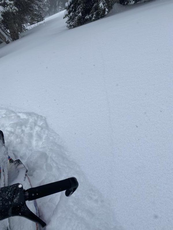
The skiing and riding have improved dramatically. Even though it doesn't look like it from the valley where rain has been falling, the mountains have 3-4 feet of supportable snow on the ground now.
Recent Avalanches
There were no avalanches reported yesterday, but that doesn't mean there weren't any because clouds and snowfall have made it hard to see many slide paths. A group of riders I spoke with at the Birch Creek TH near Preston reported experiencing many collapses on Friday which is the EXACT same thing as seeing an avalanche except the slope wasn't steep enough to slide.
A group in Gibson Basin on Friday experienced shooting cracks, another clear sign of unstable conditions.

Check HERE for all the latest observations and avalanche activity.
Ad
Avalanche Problem #1
Persistent Weak Layer
Type
Location
Likelihood
Size
Description
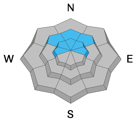
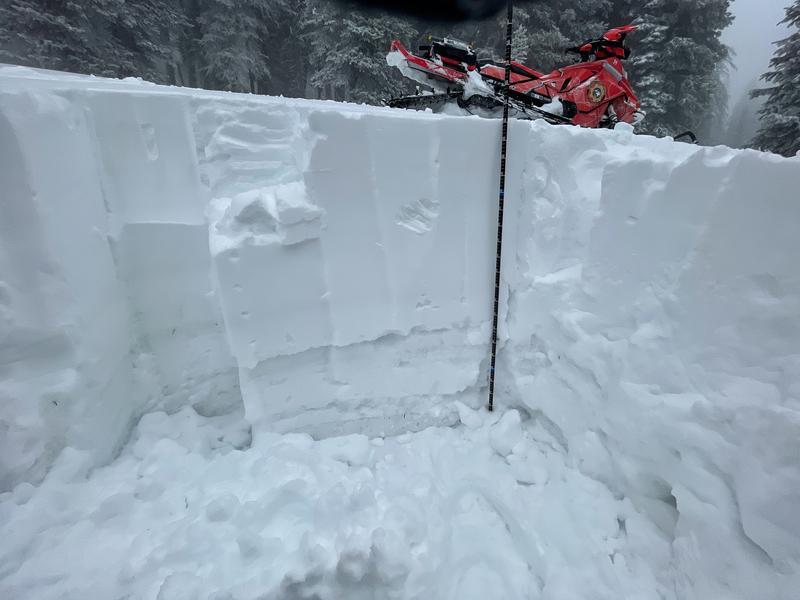
Slab avalanches breaking on a persistent weak layer near the ground are likely today. This layer of weak, sugary facets can be found 6-12 inches above the ground just above a hard ice crust that caps old snow from October and early November.
On Friday in Paris Flats and Bloomington Canyon, my partners and I found this layer in every pit we dug (see the photo below) on slopes that faced the northern half of the compass. Avalanches breaking on this layer will be 2-4 feet deep or even more on heavily wind loaded slopes. Avalanches on this layer may also break hundreds of feet across.
Avalanche Problem #2
Wind Drifted Snow
Type
Location
Likelihood
Size
Description
Winds blowing from the south, southwest, and west have been transporting snow during the last several days. These winds drifted snow mostly on slopes that have a persistent weak layer of sugary facets near the ground. While snowfall has contained 2-3 inches of snow water equivalent which is a large load by itself, wind loaded avalanche starting zones likely have 4-5 inches of water from the last several days which is a MASSIVE load that adds a huge amount of stress to deeper layers in the snowpack.
The problem with these wind slabs is that they will make avalanches breaking on the facets larger, deeper, and more deadly. Avoid any steep slope, and especially avoid any slope with obvious wind drifting where avalanches are very likely to occur.
Avalanche Problem #3
New Snow
Type
Location
Likelihood
Size
Description
Much of the new snow has likely bonded to itself. Shallow soft slabs of new snow may produce avalanches today especially during periods of intense snowfall.
Additional Information
  • Always follow safe backcountry travel protocols. Go one person at a time in avalanche terrain, while the rest of your party watches from a safe area.
  • Check your avalanche rescue equipment, change your batteries, and practice often with your backcountry partners.
  • Be very careful, keep your speed down, and stay in control. Encounters with shallowly buried rocks or down trees in the early season have led to many season-ending injuries.
  • The gate at the bottom of the Tony Grove Road was closed yesterday to preserve snow on the road for grooming.
General Announcements
Who's up for some free avalanche training? Get a refresher, become better prepared for an upcoming avalanche class, or just boost your skills. Go to https://learn.kbyg.org/ and scroll down to Step 2 for a series of interactive online avalanche courses produced by the UAC.
  • Check out all the upcoming education classes and clinics HERE.
  • Please submit your observations from the backcountry HERE.
This information does not apply to developed ski areas or highways where avalanche control is normally done. This forecast is from the U.S.D.A. Forest Service, which is solely responsible for its content. This forecast describes general avalanche conditions and local variations always occur.